Satellite signal vector tracking method based on SINS/GPS deep integration data fusion

A satellite signal and data fusion technology, applied in the field of navigation, can solve the problems of underutilized navigation information, poor performance, and failure to work normally

Inactive Publication Date: 2010-03-10
BEIHANG UNIV
View PDF0 Cites 43 Cited by
  • Summary
  • Abstract
  • Description
  • Claims
  • Application Information

AI Technical Summary

Problems solved by technology

The traditional scalar tracking method has the following defects: on the one hand, since the gain and bandwidth of the loop filter are fixed, all phase errors are treated according to the same weight, so it cannot adapt to the change of signal carrier-to-noise ratio; on the other hand, Because different track

Method used


Image

  • Satellite signal vector tracking method based on SINS/GPS deep integration data fusion
  • Satellite signal vector tracking method based on SINS/GPS deep integration data fusion
  • Satellite signal vector tracking method based on SINS/GPS deep integration data fusion

Examples


Embodiment Construction

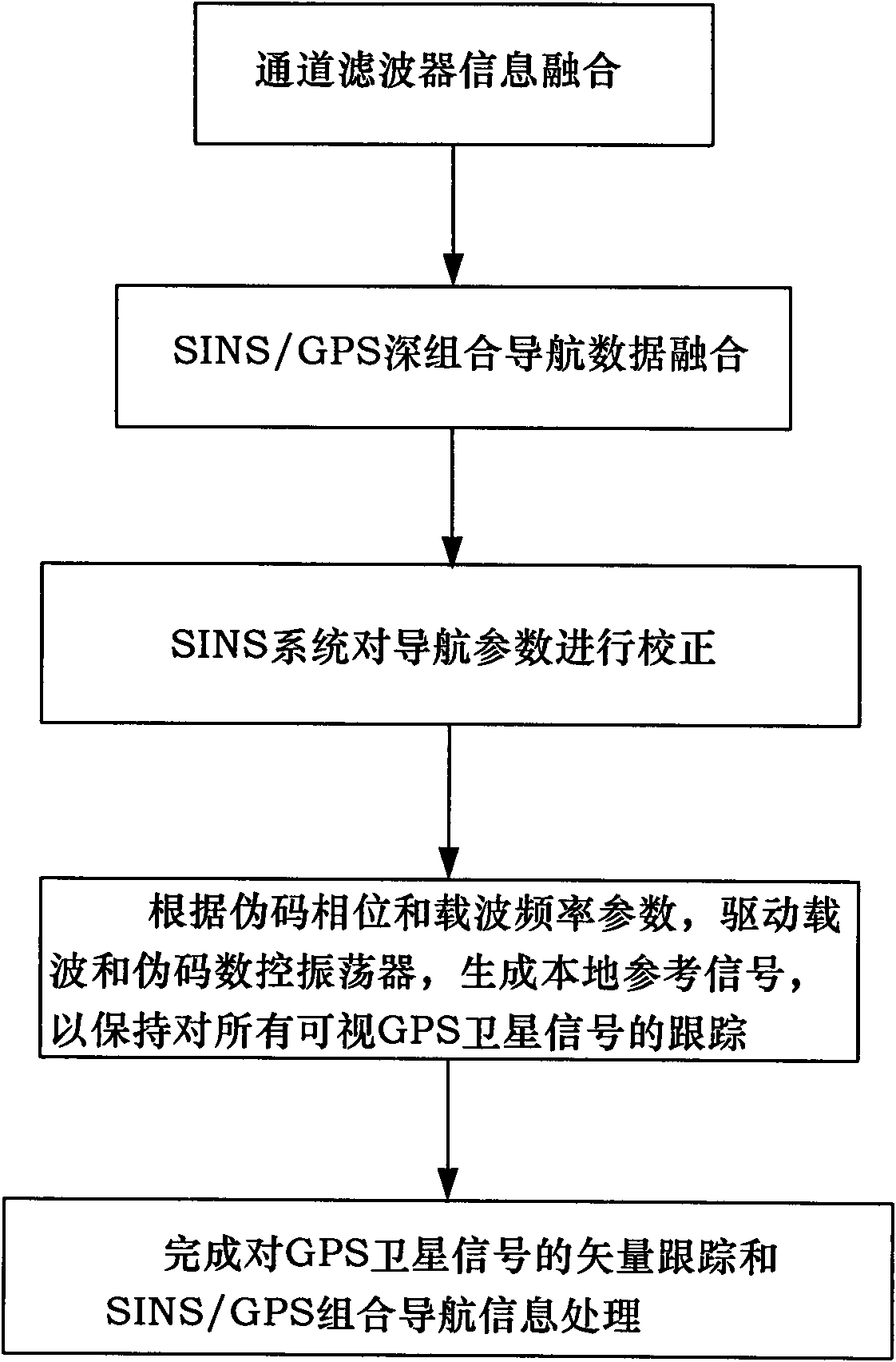
[0052] The satellite signal vector tracking method based on SINS / GPS deep combination data fusion provided by the present invention will be described in detail below in conjunction with the accompanying drawings.

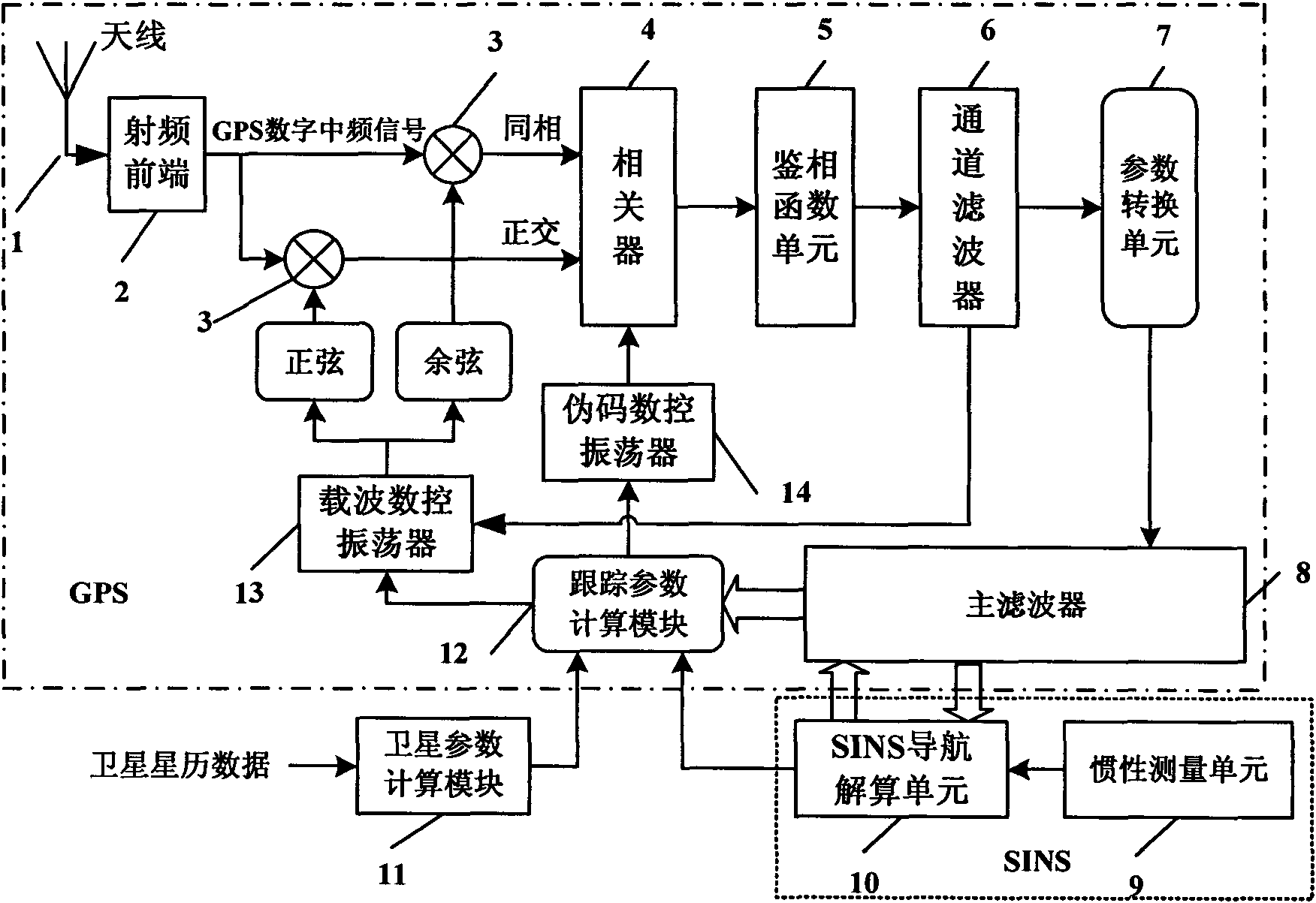
[0053] The invention provides a SINS / GPS deep integrated navigation system structure such as figure 1 As shown, the combined system mainly includes the following parts: antenna 1, radio frequency front end 2, mixer 3, correlator 4, phase detection function unit 5, channel filter 6, parameter conversion unit 7, main filter (also denoted as Integrated navigation filter) 8, inertial measurement unit (IMU) 9, SINS navigation calculation unit 10, satellite parameter calculation module 11, tracking parameter calculation module 12, carrier numerical control oscillator 13 and pseudocode numerical control oscillator 14. Among them, the inertial measurement unit 9 and the SINS navigation calculation unit 10 constitute the SINS system, and the mixer 3, the correlator 4, the ph...


PUM


Abstract

The invention discloses a satellite signal vector tracking method based on SINS/GPS deep integration data fusion. In the method, compensation is carried out on inertia element errors through channel filter information fusion, SINS/GPS deep integration navigation data fusion and an SINS system based on an SINS/GPS deep integration navigation system; and position and speed parameters of a current computation period are corrected to obtain accurate navigation parameters and generate local inference signals as well as keep the tracking for all visual GPS satellite signals; and a loop formed by channel filters and a main filter is utilized to complete the vector tracking and integration navigation information processing to the GPS satellite signals. The invention has excellent noise inhibitioncapacity and dynamic tracking performance, can ensure the navigation accuracy and the reliability of an integration system during the temporary interruption of the GPS satellite signals, and can maintain better pseudo code phase and carrier frequency tracking property in an environment with low carrier-to-noise ratio.

Description

technical field [0001] The invention belongs to the technical field of navigation, and relates to a satellite signal vector tracking method based on SINS / GPS deep combined data fusion, which can be used to improve the navigation accuracy of the SINS / GPS combined navigation system for aircraft, missiles, ships or vehicles. Background technique [0002] Strapdown Inertial Navigation System (SINS) is a completely autonomous navigation system that can provide position, velocity and attitude information continuously and in real time. It has high short-term accuracy, good concealment, and is not limited by weather conditions. , and thus widely used in aviation, aerospace, navigation and other fields. However, the SINS error increases with time, so it is often combined with the GPS global satellite positioning system to form a SINS / GPS integrated navigation system. GPS and SINS have strong complementarity in performance. The combination of the two can not only give full play to th...

Claims


Application Information

Patent Timeline
IPC IPC(8): G01S1/02G01S5/02G01C21/16
Inventor 王新龙于洁
Owner BEIHANG UNIV
Why Eureka
Try Eureka