Detection method of high-resolution remote sensing image street center line

A high-resolution, remote sensing image technology, applied in the field of image processing, can solve problems such as road width changes, incomplete road edges, large storage space, etc., to achieve the effect of ensuring correctness, enhancing accuracy, and improving accuracy

Inactive Publication Date: 2010-05-26
XIDIAN UNIV
View PDF0 Cites 13 Cited by
  • Summary
  • Abstract
  • Description
  • Claims
  • Application Information

AI Technical Summary

Problems solved by technology

The disadvantage of this method is that it takes up a lot of storage space
The disadvantage of this method is that the location of the road centerline extracted by this method is not very accurate due to incomplete road edges or road width changes
Experiments show that this method can well connect the main road network in complex areas, it is more general than general road feature extraction, and the research area is larger, which is more practical, but the disadvantage of this method is: firstly, it needs to use A suitable extraction algorithm extracts the basic roads, but it is difficult to find a suitable extraction algorithm
The disadvantages of this method are: the requirements for the seed point are very high, the seed point cannot deviate too far from the centerline of the road, and at the same time, it cannot correctly judge the road covered by shadows.

Method used


Image

  • Detection method of high-resolution remote sensing image street center line
  • Detection method of high-resolution remote sensing image street center line
  • Detection method of high-resolution remote sensing image street center line

Examples


Embodiment Construction

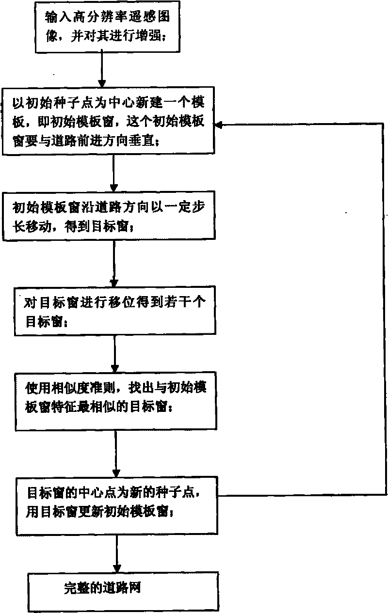
[0028] refer to figure 1 , the specific implementation steps of the present invention are as follows:

[0029] Step 1: Input a high-resolution remote sensing image, and use filtering method to enhance the input remote sensing image.

[0030] Step 2, create an initial template window;

[0031] (2a) Select an initial seed point on the road centerline in the enhanced image. The initial seed point should be selected on the center point of the road centerline. If it deviates from the center point, the error of the detection result will increase. Accurate, therefore, the center point must be corrected first to ensure that the selected initial seed point is on the center point of the center line of the road;

[0032] (2a) With the initial seed point as the center, establish a template window with a side length of (2N+1), where N is a positive integer, 0

[0033] (2c) Find the main direction of the road with a robust road main direction algorithm, the angle between the main di...


PUM


Abstract

The invention discloses a detection method of a high-resolution remote sensing image street center line on the basis of template matching, which mainly solves the problem of low accuracy of the traditional technology for detecting streets. A detecting process comprises the following steps of: (1) inputting a high-resolution remote sensing image and enhancing the image; (2) establishing an initial template window vertical to a street advance direction by using an initial seed point as a center; (3) moving the initial template window along a certain step length to obtain a target window; (4) displacing the target window to obtain a plurality of target windows; (5) using a similarity criterion to find out a target window, characteristics of which are the most similar to the characteristics of the initial template window; and (6) using the central point of the target window as a new seed point, and updating the initial template window by using the target window to carry out a next iteration until the boundary of the image is searched or streets in the image finish being searched so as to obtain a street center line using a circle as a mark. The method is accurate and effective, and can be used for the detection of the high-resolution remote sensing image street center line.

Description

technical field [0001] The invention belongs to the technical field of image processing, relates to the detection of road networks, and can be used for the detection and identification of road networks in high-resolution remote sensing images. Background technique [0002] Extracting roads from remote sensing images is an important research topic in image processing and target recognition. Road information is an important geographic thematic information in satellite images. It not only has theoretical and methodological significance in the automatic interpretation of satellite digital images, but also can use the extracted road information as a data source to update the geographic information system database extensively. It is used in many fields of national economy. [0003] Judging from the current progress, there are still great difficulties in the automatic extraction of roads. The existing technology has not yet achieved satisfactory results in terms of completeness an...

Claims


Application Information

Patent Timeline
Patent Type & Authority Applications(China)
IPC IPC(8): G06K9/46G01S7/48
Inventor 张小华侯彪杨园园焦李成王爽刘芳钟桦缑水平
Owner XIDIAN UNIV
Why Eureka
Try Eureka