

Two-outside and two-inside measuring method for large-scale aviation digital photography
A measurement method and aerial photography technology, applied in the field of aerial photogrammetry, can solve the problem that the mathematical accuracy of the mapping cannot well meet the requirements of the specification, and achieve the effect of obvious qualitative and positioning effects, high data accuracy, and shortening the period of aerial surveying and mapping.
- Summary
- Abstract
- Description
- Claims
- Application Information
AI Technical Summary
Problems solved by technology
Method used
Image


Examples
Embodiment 1
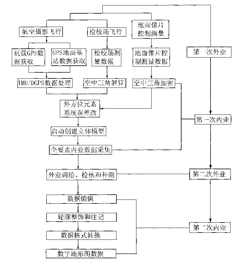
[0023] Such as figure 1 A method of measuring both outside and inside for large-scale aerial digital photography shown includes the following steps:
[0024] Step 1. Aerial photogrammetry and acquisition of photo control measurement data: According to the preliminary design route, use DMC digital camera system and IMU / DGPS navigation and positioning technology to conduct aerial photography flight and calibration field flight, and use GPS-RTK system, level and total station After the flight, the airborne GPS data, GPS ground base station data, calibration field measurement data, and ground photo control measurement data are obtained. The ground photo control measurement adopts a regional four-corner point layout measurement scheme;
[0025] Step 2. All-element data collection: Under the SSK all-digital photogrammetry workstation and the DMS all-digital mapping system, perform air triangulation encryption on the ground photo control measurement data obtained in the above step 1 ...
Embodiment 2
[0038] With the above method and steps, we completed a 1:1000 digital topographic map of about 1100 square kilometers in Daya Bay, Xinxiang, Puyang, Baotou, Tongchuan and Hami.
[0039] Table 3: Accuracy statistics of digital topographic maps with a scale of 1:1000 completed in recent years
[0040]
[0041]
[0042] Comparing the data in Table 3 and Table 2, it can be seen that the above-mentioned digital topographic map is completed with a scale of 1:1000 using this method, and its accuracy can meet the requirements of urban survey specifications, that is, the errors in the points are all less than 0.5 mm, and the errors in the distances are all less than 0.4 mm, and the errors in elevation are all within 0.15m.
Embodiment 3
[0044] We also carry out 1:1000 or 1:500 digital topographic maps in other areas with the above method steps.
[0045] Table 4: Statistical Table of Mathematical Accuracy Achieved by Digital Line Drawings in Part of the Survey Area in Recent Years
[0046]
[0047] Comparing the data in Table 4 and Table 2, it can be seen that the accuracy of the above-mentioned 1:1000 or 1:500 digital topographic map completed by this method can meet the requirements of urban survey specifications, that is, the errors in points are all less than 0.5 mm, and the errors in spacing are all less than 0.5 mm. 0.4mm, and the errors in the elevation are all within the urban measurement norms.
[0048] In aerial digital photogrammetry, the primary quality elements of digital line-drawing topographic map products are mathematical accuracy and attribute accuracy. Among them, mathematical accuracy is an important index for mapping, and it is also a rigid index for whether the mapping is qualified. A...
PUM
 Abstract
Description
Claims
Application Information