Multi-version open geographic information service access method and system based on fragment pattern matching

A geographic information service and pattern matching technology, applied in the field of multi-version open geographic information service access, can solve the problems of time and space waste, wrong matching, and reduce matching quality, and achieve the effect of improving performance

Inactive Publication Date: 2010-06-02
WUHAN UNIV
View PDF0 Cites 7 Cited by
  • Summary
  • Abstract
  • Description
  • Claims
  • Application Information

AI Technical Summary

Problems solved by technology

[0009] The difference between different versions of the network service pattern file and the characteristics of the network service pattern file itself determine that using

Method used


Image

  • Multi-version open geographic information service access method and system based on fragment pattern matching
  • Multi-version open geographic information service access method and system based on fragment pattern matching
  • Multi-version open geographic information service access method and system based on fragment pattern matching

Examples


Embodiment Construction

[0055] Below in conjunction with accompanying drawing, the present invention will be further described with specific embodiment:

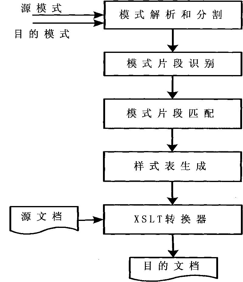
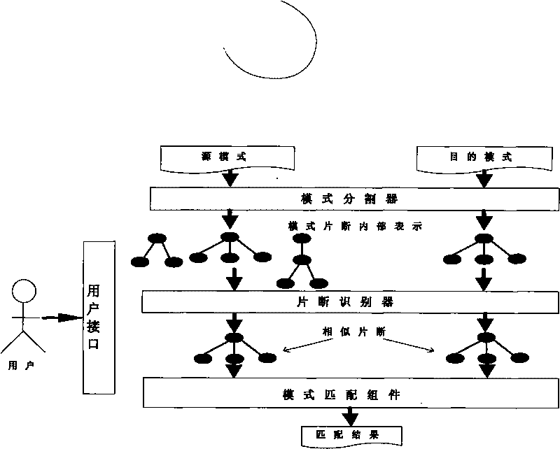
[0056] The multi-version open geographic information service access method based on fragment pattern matching proposed by the present invention specifically adopts the following technical solutions, such as figure 1 shown, including the following steps:

[0057] Step 1: Input a source pattern file and a target pattern file to be matched through the user interface, dynamically analyze the pattern file through the pattern parser, and output the pattern file representation graph (tree); the purpose of dynamic parsing in this step is In order to manage all elements and their relationships in a schema file using a relational database, due to the characteristics of network service schema files, for example, a schema file often imports elements defined in other schema files through import, include, etc., so it is implemented in the parsing process The dy...


PUM


Abstract

The invention relates to the technical field of geographic information service, in particular to multi-version open geographic information service access method based on fragment pattern matching, which comprises the steps of: inputting a source pattern file and a destination pattern file which are to be matched through a user interface; dynamically analyzing the pattern files by using a pattern analyzer; designing a pattern manager to manage the analyzed pattern files; designing a pattern matching assembly to match the pattern files; selecting an optimum matcher or matching combining method to match the pattern files; and carrying out fragment pattern matching. The invention improves the performance of the pattern matching, greatly improves the matching quality in comparison with the traditional method, and has higher matching quality and higher matching efficiency than that of the traditional pattern matching method, such as COMA and CUPID, which proves that the multi-version open geographic information service access method is more practical and reliable in network service pattern matching.

Description

technical field [0001] The present invention relates to the technical field of geographic information services, in particular to a multi-version open geographic information service access method and system based on fragment pattern matching. Background technique [0002] The open geographic information system (Open GIS) interoperability specification refers to the sharing of geography, spatial data and geographic information processing resources in a distributed environment within the country and the world. It allows users to obtain geographic information in different systems in real time through the network. , avoiding redundant data storage. The open geographic information system is realized through the open geospatial data interoperability specification (Open Geo-data Interoperability Specification, referred to as OG IS), and its core is OGIS. [0003] OGC defines different information models for different types of network services, and also defines different schema file...

Claims


Application Information

Patent Timeline
IPC IPC(8): G06F17/30H04L29/08
Inventor 陈能成何杰王伟
Owner WUHAN UNIV
Why Eureka
Try Eureka