Real-time high-precision locating method used for surveying and mapping and navigating

A positioning method and high-precision technology, applied in positioning, measuring devices, radio wave measuring systems, etc., can solve problems such as difficulty in correct fixation and difficulty in solving ambiguity, and achieve the effects of strong stability, high precision, and cost savings

Inactive Publication Date: 2010-06-23
TONGJI UNIV
View PDF0 Cites 26 Cited by
  • Summary
  • Abstract
  • Description
  • Claims
  • Application Information

AI Technical Summary

Problems solved by technology

Since the combined wavelength of the wide-lane composed of two GPS frequencies is about 86 cm, the ionosphere-free combined wavelength of the basic carrier is only 10 cm. In addition to the influence of the troposphere and multipath effects, it is very difficult to solve the ambiguity, especially the ambiguity of the basic carrier degree, it is extremely difficult to fix correctly
Therefore, the current navigation accuracy using the differential signal of a single reference station is only at the meter level, and only the multi-reference station technology can achieve centimeter-level positioning

Method used


Image

  • Real-time high-precision locating method used for surveying and mapping and navigating
  • Real-time high-precision locating method used for surveying and mapping and navigating
  • Real-time high-precision locating method used for surveying and mapping and navigating

Examples


Embodiment 1

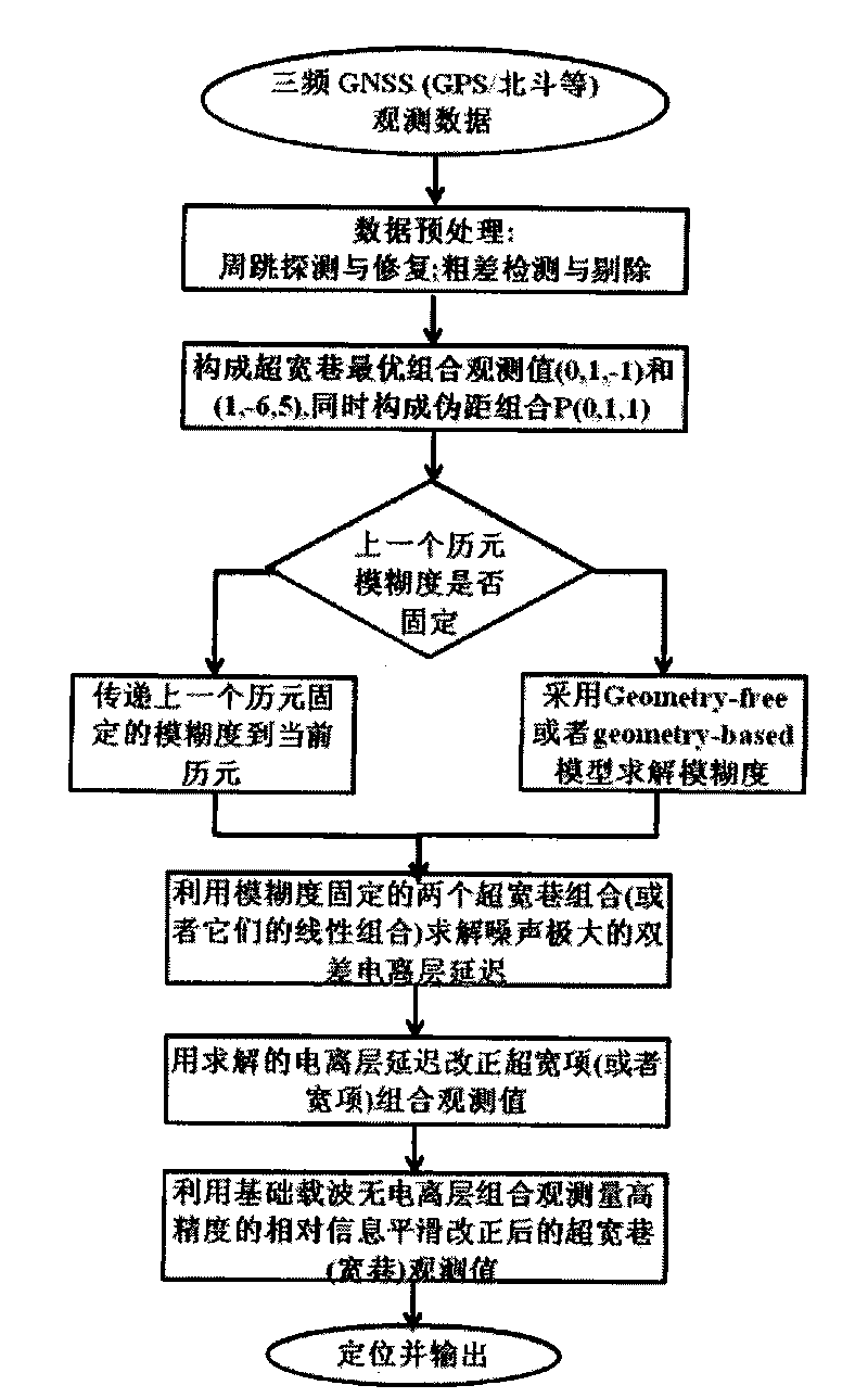
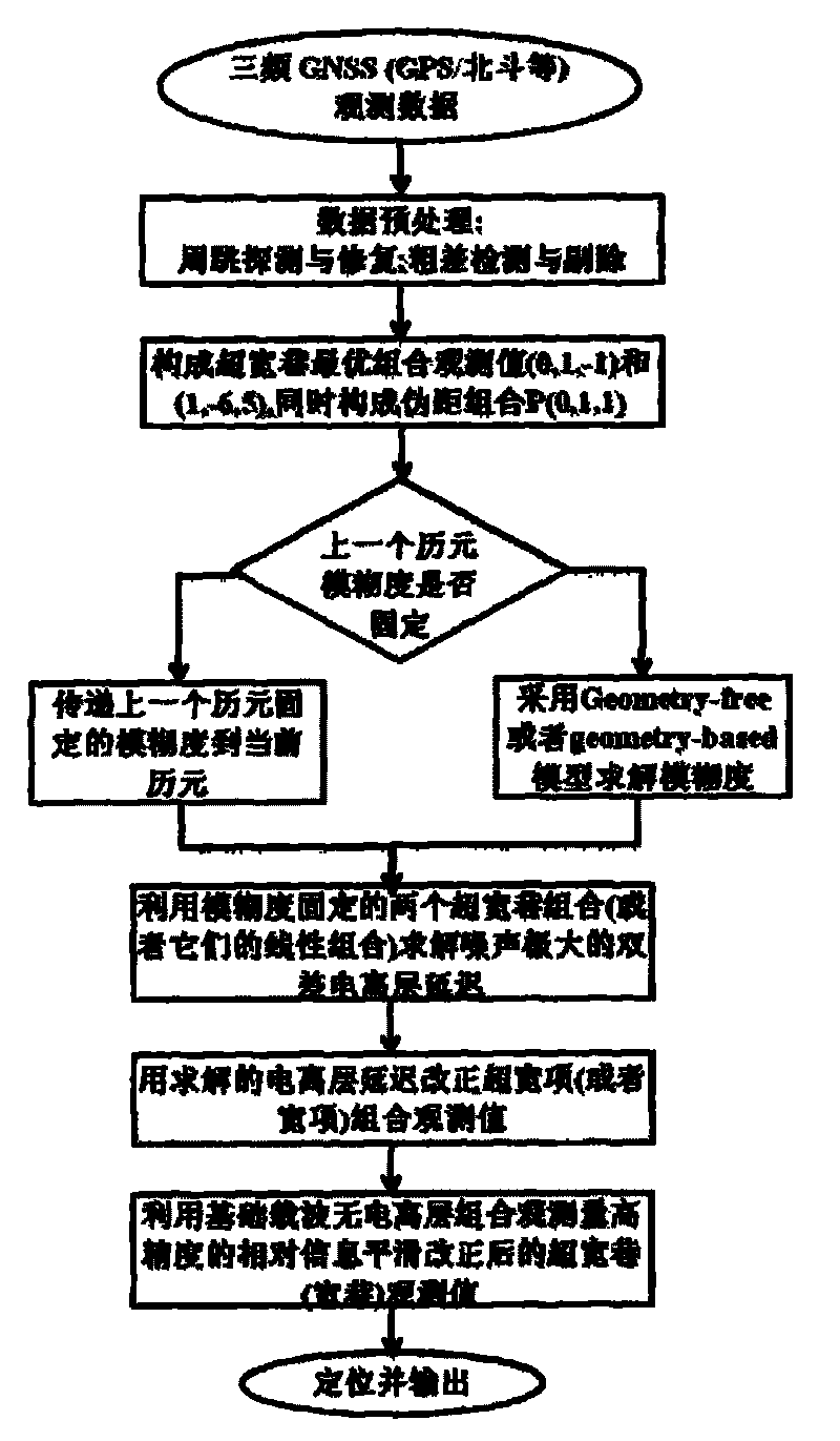
[0042] like figure 1 , this implementation first uses the noisy ionospheric delay obtained by combining two ultra-wide lanes to correct the observed values ​​of the ultra-wide lane (wide lane), and then smoothes the corrected ultra-wide lane (wide lane) observations, using Smoothed high-precision observation positioning.

Embodiment 2

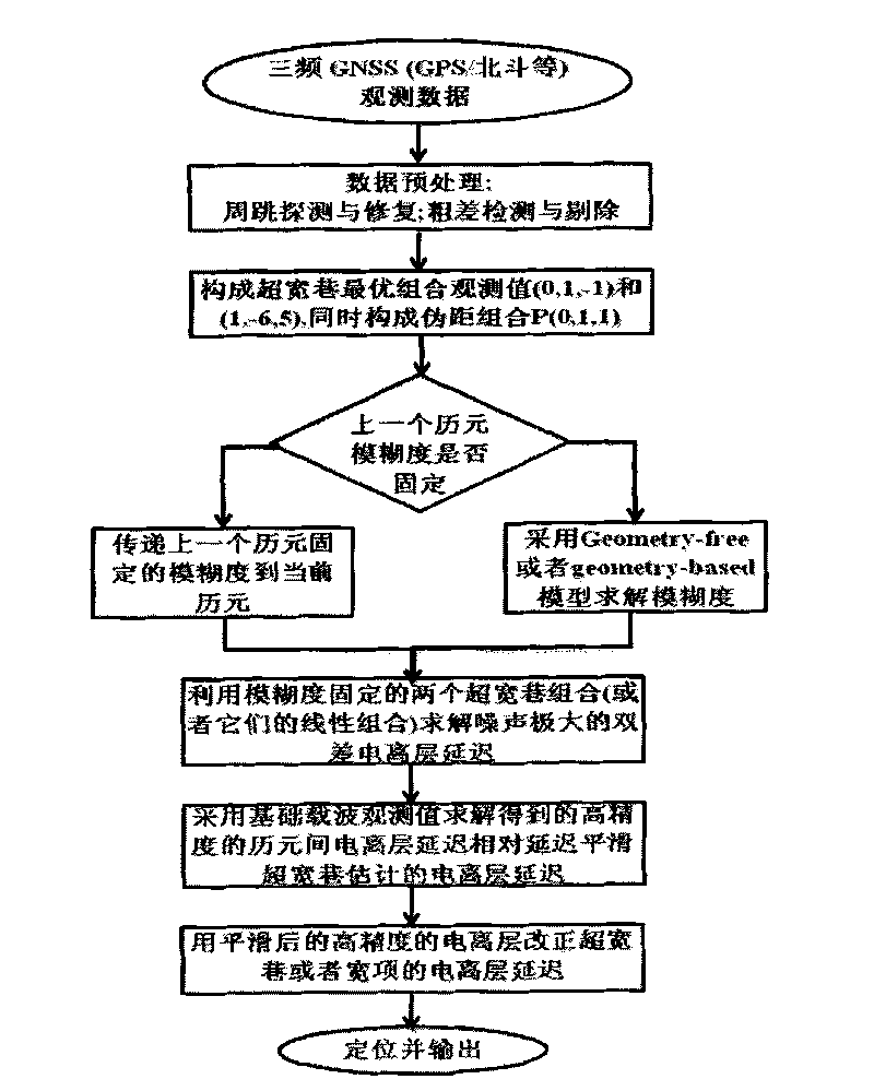
[0044] like figure 2 , this embodiment smooths the ionospheric delay with high noise obtained by combining two ultra-wide lanes to obtain a high-precision ionospheric delay, and then uses the high-precision ionospheric delay to correct the super-wide lane (wide lane) observation value, using The corrected observations are directly positioned.

[0045] The concrete problem that the present invention should pay attention to in actual operation is as follows:

[0046] First set up the reference station. The reference station should be located in the center of the survey area as much as possible. It is required that the surrounding observation environment is good and the field of view is wide. The height angle of the surrounding obstacles in the field of view should generally be less than 10 degrees; Radio transmission sources (such as radio stations, microwave stations and microwave channels, etc.) and high-voltage lines to avoid the interference of the surrounding magnetic fie...


PUM


Abstract

The invention relates to a real-time high-precision locating method used for surveying and mapping and navigating, which comprises the following steps of: preprocessing triple-frequency observed data of a reference station and a mobile station, forming ultra-wide lane optimal combination observed values phi(0,1,-1) and phi(1,-6,5) and narrow lane combination observed values P(0,1,1) by adopting the processed triple-frequency observed data of the reference station and the mobile station, and detecting whether the ambiguity of the previous epoch is constant or not; if the ambiguity of the previous epoch is constant, delivering the constant ambiguity of the previous epoch to the current epoch on the premise of ensuring that the cycle slip is correctly processed; if the ambiguity of the previous epoch is not constant, enabling the optimal combination ambiguity to be constant by utilizing Geometry-free and Geometry-based models; and reversely solving ionospheric delay by utilizing two ultra-wide lane observed values with constant ambiguity and correcting any one wide lane observed value; smoothing the ionospheric correction wide lane observed values to obtain high-precision observed data; and locating with the high-precision observed data. The invention has simple arithmetic, high precision, stable performance and wide range of application.

Description

technical field [0001] The invention relates to a positioning technology for surveying, mapping and navigation, in particular to a real-time high-precision positioning method for surveying, mapping and navigation. Background technique [0002] As a revolutionary development of surveying and mapping technology in the 20th century, the Global Positioning System (GPS) has been widely used in navigation, geodesy, geodynamics, and natural disaster monitoring. The means have changed dramatically. In the past nearly 20 years, GPS in the United States has always been a representative of the application of satellite positioning technology and has been in a monopoly position. However, the original intention of GPS is to serve the U.S. military, assisting weapons to accurately lock targets, so the GPS system monopolized by the United States seriously threatens the military security of various countries. With the technological and economic development of various alliances and superpow...

Claims


Application Information

Patent Timeline
Patent Type & Authority Applications(China)
IPC IPC(8): G01S5/00
Inventor 李博峰沈云中周泽波
Owner TONGJI UNIV
Why Eureka
Try Eureka