Deep space autonomous navigation method based on observability degree analysis

A technology of autonomous navigation and autonomous navigation system, which is applied in the field of aerospace and aviation, can solve the problems of lower utilization rate of observation information, lower adaptive ability and reliability of autonomous navigation system, etc., to improve adaptive ability and reliability, and improve utilization rate Effect

Inactive Publication Date: 2010-06-30
HARBIN INST OF TECH
View PDF0 Cites 19 Cited by
  • Summary
  • Abstract
  • Description
  • Claims
  • Application Information

AI Technical Summary

Problems solved by technology

[0004] The purpose of the present invention is to solve the problem that when the existing autonomous navigation system comprehensively utilizes different observation models to provide measurement information, it needs to process different types of measurement information

Method used


Image

  • Deep space autonomous navigation method based on observability degree analysis
  • Deep space autonomous navigation method based on observability degree analysis
  • Deep space autonomous navigation method based on observability degree analysis

Examples


specific Embodiment approach 1

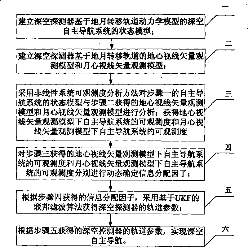
[0013] Specific implementation mode one: combine figure 1 Describe this embodiment, a deep space autonomous navigation method based on observability analysis described in this embodiment, the specific steps are:

[0014] Step 1: Establish the state model of the deep space autonomous navigation system of the deep space probe based on the dynamic model of the Earth-Moon transfer orbit;

[0015] Step 2: Establish the earth-center line-of-sight vector observation model and the moon-center line-of-sight vector observation model of the deep space probe based on the earth-moon transfer orbit;

[0016] Step 3: Analyze the state model of the autonomous navigation system in step 1 and the geocentric line-of-sight vector observation model and moon-centered line-of-sight vector observation model obtained in step 2 by using the nonlinear system observability analysis method; obtain the geocentric line-of-sight vector observation model The observability of the autonomous navigation system ...

specific Embodiment approach 2

[0021] Specific embodiment two: the difference between this embodiment and the deep space autonomous navigation method based on observability analysis described in embodiment one is that the state model of the deep space autonomous navigation system described in step one is:

[0022]

[0023] In the formula, r=[xyz] T is the position of the detector in the inertial system, v=[v x v y v z ] T is the speed of the detector in the inertial system, X=[r T v T ] T is the system state variable; μ is the gravitational constant of the earth, J 2 is the gravitational coefficient perturbed by the shape of the earth, R c is the mean equatorial radius of the earth; where x m ,y m ,z m is the position component of the moon in the inertial system, r m is the radius of the moon in the inertial system; r sm is the radius of the moon relative to the probe; w is the error of the system model, and the state model of the above-mentioned deep space autonomous navigation system is als...

specific Embodiment approach 3

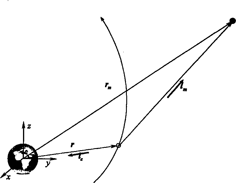
[0025] Specific implementation mode three: combination figure 2 Describe this embodiment. The difference between this embodiment and the deep-space autonomous navigation method based on observability analysis described in Embodiment 1 lies in the observation model of the earth-centered line-of-sight vector and the moon-centered line-of-sight vector observation described in step 2. model, whose expression is as follows:

[0026] The geocentric line-of-sight vector observation model is

[0027]

[0028] where Θ e is the altitude angle in the direction of the center of the earth, Φ e is the geocentric azimuth;

[0029] The lunar center line of sight vector observation model is

[0030]

[0031] where Θ m is the altitude angle in the direction of the moon center, Φ m is the azimuth of the lunar center.

[0032] In this embodiment, the earth-centered line-of-sight vector and the moon-centered line-of-sight vector are measured observation equations, and the attitude co...


PUM


Abstract

The invention discloses a deep space autonomous navigation method based on observability degree analysis, which relates to the field of aerospace. The invention solves the problems that when the current autonomous navigation systems comprehensively use different observing models to provide measuring information, different types of measuring information of different sensors need to be processed, thereby reducing the utilization ratio of the observed information and simultaneously reducing the adaptive ability and reliability of the autonomous navigation systems. The method of the invention is established on the basis of a dynamic model of an earth-moon transfer orbit deep space probe, obtains the observability degree of the deep space autonomous navigation system under two observing models of a geocentric sight line vector and a selenocentric sight line vector by a nonlinear system observability degree analyzing method, and acquires the orbit parameters of the deep space probe by a UKF based federal filtering algorithm. The invention is suitable for determining the orbit parameters of deep space separated section and transfer section probes. The invention can be used for improving the accuracy and reliability of the deep space autonomous navigation system, and is especially suitable for the information fusion autonomous navigation technologies under various observing models.

Description

technical field [0001] The invention relates to a method for determining an autonomous orbit of a deep space probe, which belongs to the field of aerospace. Background technique [0002] Autonomous navigation technology is currently a research hotspot in deep space exploration missions. Autonomous navigation means that the probe can determine the position, speed and other parameters of the probe in real time without relying on the ground station and only relying on the spaceborne measurement equipment. It is an important part and key technology of the autonomous operation technology of the probe. Autonomous navigation technology can reduce the complexity of operation, enhance the autonomous survivability of the probe, and provide support for the autonomous capabilities of attitude control, maneuver planning, and orbit control, thereby expanding the space application potential of deep space probes. [0003] With the development of aerospace technology, the scientific purpose...

Claims


Application Information

Patent Timeline
IPC IPC(8): G01C21/24G01C21/16
Inventor 崔平远崔祜涛常晓华徐田来
Owner HARBIN INST OF TECH
Why Eureka
Try Eureka