Method for autonomously monitoring integrity of monitoring stations of global navigation satellite system augmentation system
A global navigation satellite and augmentation system technology, applied in the field of self-completeness monitoring, can solve problems such as the inability to guarantee the accuracy of monitoring stations, and achieve the effect of ensuring rigidity and strong reliability
- Summary
- Abstract
- Description
- Claims
- Application Information
AI Technical Summary
Problems solved by technology
Method used
Image

Examples
Embodiment Construction
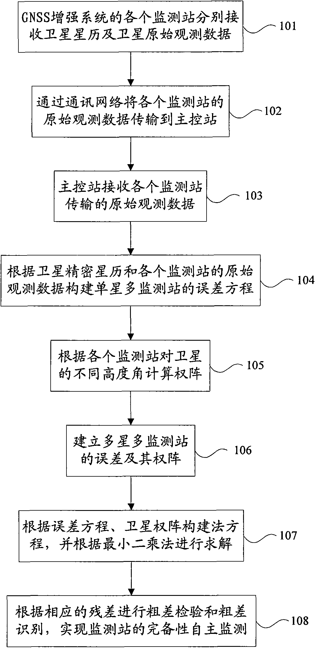
[0048] In order to make the object, technical solution and advantages of the present invention clearer, the present invention will be further described in detail below in conjunction with the accompanying drawings.
[0049] figure 1 It is a flow chart of the monitoring station autonomous completeness monitoring method provided in this embodiment, and the method includes:
[0050] Step 101 , each monitoring station of the GNSS augmentation system receives satellite ephemeris and raw satellite observation data respectively. GNSS augmentation system monitoring stations are distributed within the working range covered by the network, and each monitoring station is an independent GNSS station, each receiving corresponding GNSS satellite ephemeris and original observation data. Satellite ephemeris is broadcast every two hours and can be used to calculate satellite position coordinates. The original observations of satellites generally include pseudo-range observations, precise cod...
PUM
 Abstract
Description
Claims
Application Information
 - Generate Ideas
- Intellectual Property
- Life Sciences
- Materials
- Tech Scout
- Unparalleled Data Quality
- Higher Quality Content
- 60% Fewer Hallucinations
Browse by: Latest US Patents, China's latest patents, Technical Efficacy Thesaurus, Application Domain, Technology Topic, Popular Technical Reports.
© 2025 PatSnap. All rights reserved.Legal|Privacy policy|Modern Slavery Act Transparency Statement|Sitemap|About US| Contact US: help@patsnap.com