Safe airplane approach method based on multisensor information fusion

A multi-sensor, aircraft technology, applied in aircraft traffic control, aircraft ground control, instruments, etc., to achieve the effect of improving the level of aviation safety management

Active Publication Date: 2010-12-22
内蒙古盛邦北斗卫星信息服务有限公司
View PDF6 Cites 61 Cited by
  • Summary
  • Abstract
  • Description
  • Claims
  • Application Information

AI Technical Summary

Problems solved by technology

Under complex weather conditions, the existing airport surveillance system cannot guarantee the effective detection of air and ground targets

Method used


Image

  • Safe airplane approach method based on multisensor information fusion
  • Safe airplane approach method based on multisensor information fusion

Examples


Embodiment Construction

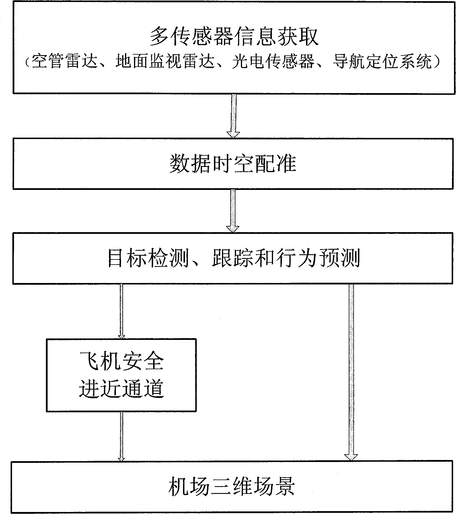
[0023] Such as figure 1 Shown, the concrete implementation method of the present invention is as follows:

[0024] (1) Use the airport air traffic control radar, ground surveillance radar, and navigation and positioning system to obtain aircraft information, and perform time-space synchronous registration and fusion of the information. The steps to calculate the three-dimensional position information of the aircraft are:

[0025] ① Registration and fusion of aircraft information acquired by ground surveillance radar, air traffic control radar and navigation and positioning system;

[0026] ② Carry out coordinate transformation on the fused aircraft information, transform the aircraft information from the polar coordinates to the spatial rectangular coordinate system, and obtain the three-dimensional position information of the aircraft in the world coordinate system.

[0027] (2) Register and fuse the visible light image and infrared image information collected by the photoel...


PUM


Abstract

The invention relates to a safe airplane approach method based on multisensor information fusion. In the method, space-time registration and fusion are carried out on a flight control radar, a ground surveillance radar, navigation localization information, infrared and visible light image information to obtain space and ground target (barrier, people, vehicle and airplane) information, automatically generate a safe airplane approach channel and display both the targets and safe approach channel information in the three-dimensional airport scene in a fused mode. The concrete implementation steps are as follows: firstly, employing a radar and a navigation positioning system to obtain airplane information and carrying out time-space registration and fusion to obtain three-dimensional airplane information; secondly, carrying out detection, tracking and behavior prediction on ground targets to obtain track information of ground targets by using the information obtained after registration and fusion of visible light and infrared images are performed; thirdly, reestablishing a three-dimensional airplane information scene; and finally, fusing the real time detected target information in the three-dimensional airplane information scene and establishing the safe airplane approach channel and displaying the channel in the three-dimensional airplane information scene in real time so as to provide decision-making information for flight control personnel.

Description

technical field [0001] The invention relates to an aircraft safe approach method based on multi-sensor information fusion, which can be used in the field of aviation safety management to realize real-time monitoring of air and ground targets, provide auxiliary decision-making information for airport air traffic control personnel, and reduce accident / symptom rates. Background technique [0002] In the existing air traffic control system, surveillance radar is used to monitor and predict the trajectory of aircraft, but most of the runway intrusion events on the ground rely on people to complete the surveillance and guidance, especially in complex weather conditions, relying on The guidance of the ground control personnel completed the approach and landing of the aircraft. [0003] During the approach and landing, the aircraft is in a high-density traffic area around the airport, and the crew needs to complete complex operating procedures, especially under the conditions of cha...

Claims


Application Information

Patent Timeline
Patent Type & Authority Applications(China)
IPC IPC(8): G08G5/00G08G5/06
Inventor 赵龙李铁军
Owner 内蒙古盛邦北斗卫星信息服务有限公司
Why Eureka
Try Eureka