Street view dynamic navigation system and method thereof

A navigation system and street view technology, applied to road network navigators, radio wave measurement systems, measurement devices, etc., can solve the problem that the navigation system cannot truly reflect the road conditions, and achieve the effect of intuitive navigation and convenient use

Inactive Publication Date: 2011-04-13
CHUNGHWA TELECOM CO LTD
View PDF0 Cites 19 Cited by
  • Summary
  • Abstract
  • Description
  • Claims
  • Application Information

AI Technical Summary

Problems solved by technology

[0003] In order to solve the problem that the existing navigation system cannot truly reflect the actual road conditions, the present invention provides a street view dynamic navigation system that can truly reflect the actual road conditions

Method used


Image

  • Street view dynamic navigation system and method thereof
  • Street view dynamic navigation system and method thereof
  • Street view dynamic navigation system and method thereof

Examples


Embodiment Construction

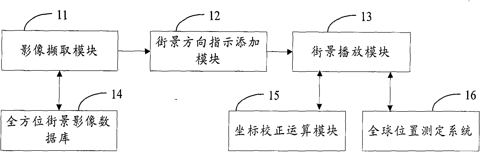
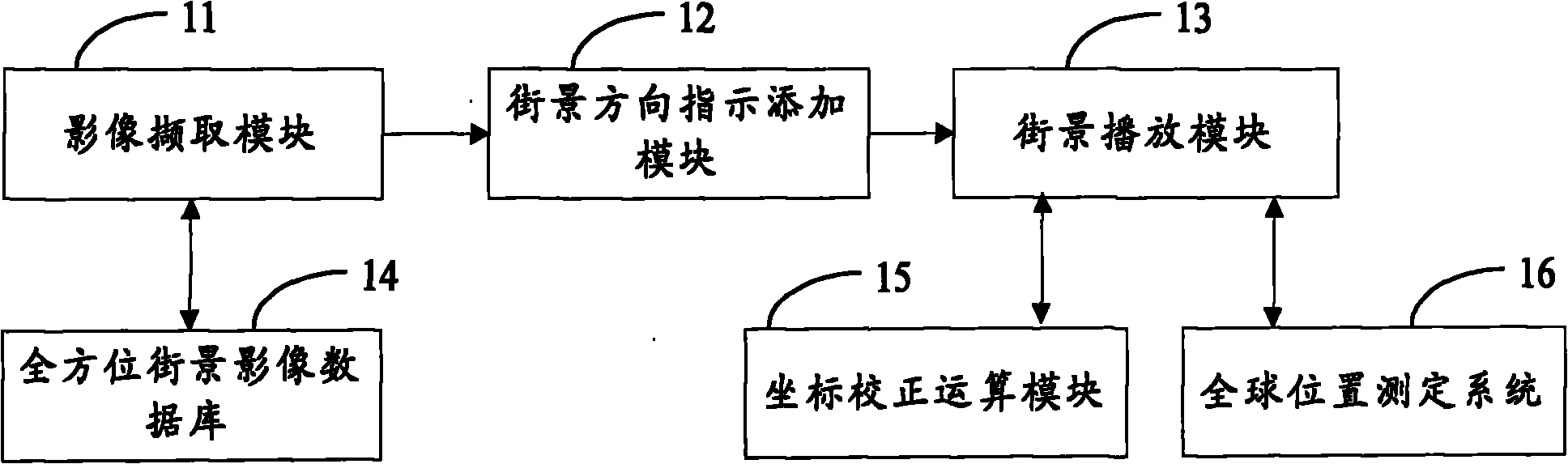
[0019] see figure 1 , figure 1 It is a structure diagram of the street view dynamic navigation system of the present invention. The street view dynamic navigation system includes: an image capture module 11, a street view direction indication adding module 12, a street view playback module 13, an omnidirectional street view image database 14, a coordinate correction calculation module 15 and a global position determination system 16 .

[0020] The omni-directional street view image database 14 stores the omni-directional image photos and corresponding longitude and latitude coordinates captured by the image capture vehicle along all streets along the road, and the omni-directional street view image database 14 stores all street view images;

[0021] The image capture module 11 captures the street view image stream corresponding to the planned route from the omnidirectional street view image database 14, and the street view image can be an actual image or a sample image in a ...


PUM


Abstract

The invention provides a street view dynamic navigation system and a method thereof. The method comprises the steps of: establishing a whole block street view image database, capturing the image streaming of all coordinate strings of a planned path along the way from the whole block street view image database by using an image capturing module, carrying out direction indication processing on a manuscript image captured by the image capturing module by using a street view direction indication addition module, and finally providing a real-time street view image streaming film processed by the street view direction indication addition module by using a street view playing module through localization coordinate signals of a global positioning system (GPS), which are received in real time, and combining with a coordinate calibration operation. In the invention, by using the street view image streaming technology, a whole-journey live-action navigation effect is achieved, road images seen by a user within a vision angle are played, and the user can be guided to arrive at a destination from a start location step by step.

Description

technical field [0001] The invention relates to a dynamic navigation system of a street view, and also relates to a dynamic navigation method of a street view. Background technique [0002] The current vehicle navigation technologies on the market all rely on road network image data. Various manufacturers combine information such as road network connectivity, road importance level, road speed limit, and road prohibition of left and right turns, with real-time road conditions, to comprehensively calculate An ideal route to travel. However, no matter whether the navigation system uses a car navigation device, mobile phone, instrument panel or windshield to provide images, it only uses the electronic map as the base map, with text to display the next turn information. Marking or simulating the real scene makes it easier for users to identify the driving path. However, no matter whether it is an enlarged electronic map or a simulated sample pattern, it is impossible to truly e...

Claims


Application Information

Patent Timeline
Patent Type & Authority Applications(China)
IPC IPC(8): G01C21/34G01C21/36G01S5/02
Inventor 萧志晖王超伟陈正扬魏龙吉黄志雄
Owner CHUNGHWA TELECOM CO LTD
Why Eureka
Try Eureka