Self-adaptive filtering method based on different measuring characteristics of GPS (Global Positioning System)/INS (Inertial Navigation System) integrated navigation system

An integrated navigation system and adaptive filtering technology, which is applied in the direction of measuring devices, radio wave measurement systems, satellite radio beacon positioning systems, etc., can solve the problems affecting the filtering accuracy, theoretical research stage, and not widely used, so as to improve positioning Accuracy, simple method, real-time tracking effect

Inactive Publication Date: 2011-06-15
BEIHANG UNIV
View PDF4 Cites 47 Cited by
  • Summary
  • Abstract
  • Description
  • Claims
  • Application Information

AI Technical Summary

Problems solved by technology

IAE uses the information sequence to adaptively estimate the statistical characteristics of the noise (the typical representative is the sage-husa algorithm), but the iterative operation between the filtering parameters in this process is likely to cause error coupling and affect the filtering accuracy.
MMAE calculates the state estimation of each filter

Method used


Image

  • Self-adaptive filtering method based on different measuring characteristics of GPS (Global Positioning System)/INS (Inertial Navigation System) integrated navigation system
  • Self-adaptive filtering method based on different measuring characteristics of GPS (Global Positioning System)/INS (Inertial Navigation System) integrated navigation system
  • Self-adaptive filtering method based on different measuring characteristics of GPS (Global Positioning System)/INS (Inertial Navigation System) integrated navigation system

Examples


Embodiment Construction

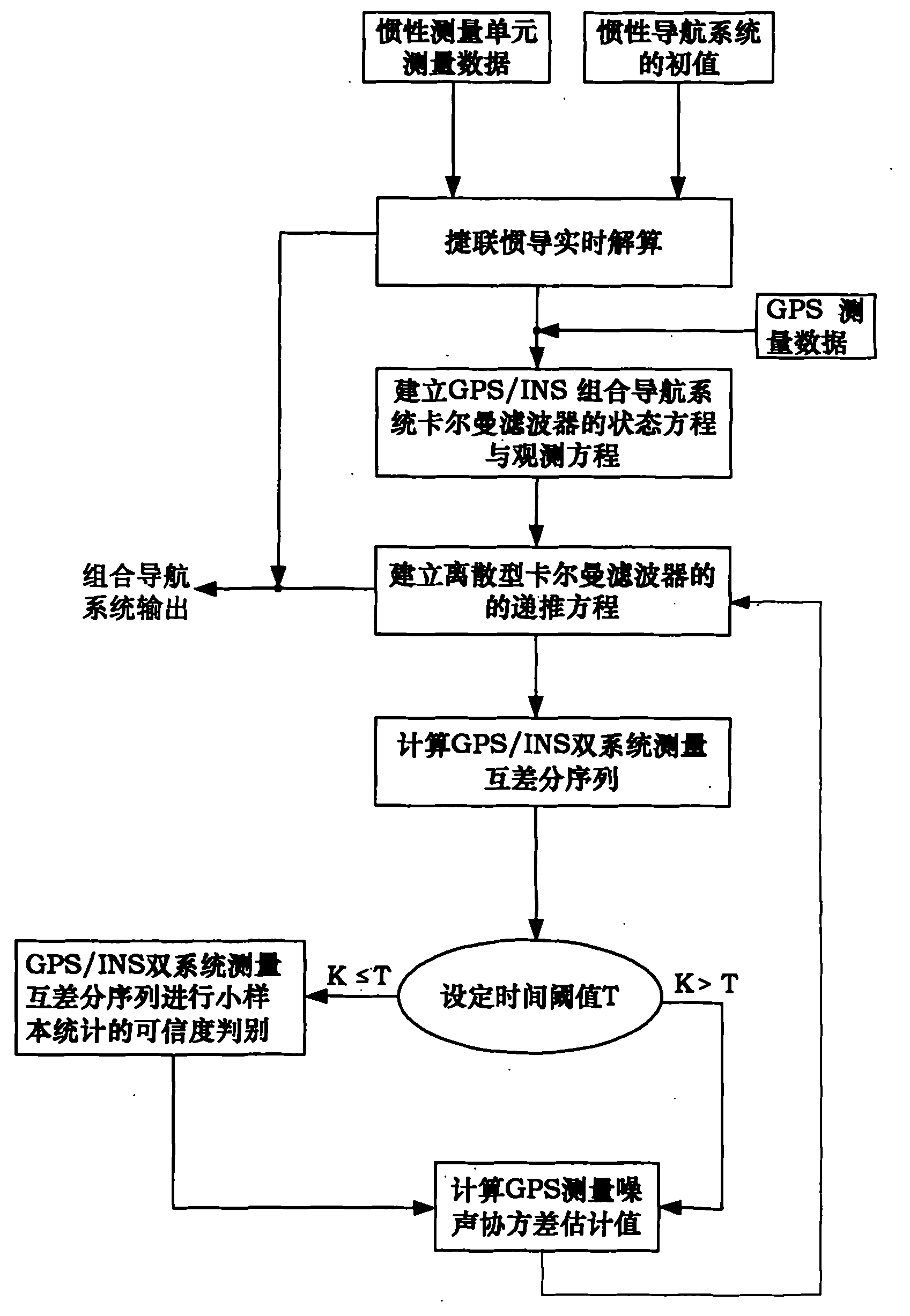
[0026] The present invention will be further described in detail below in conjunction with the accompanying drawings and embodiments.

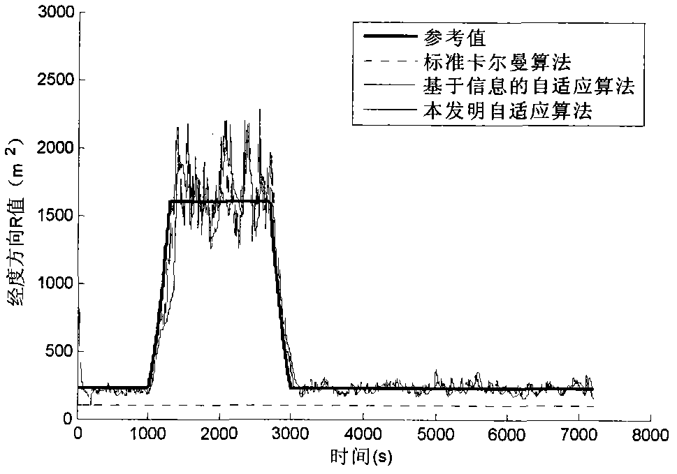
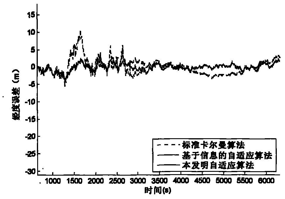
[0027] The initial position of the carrier in this embodiment is 116° east longitude, 39.2° north latitude, 1000m altitude, 300m / s speed, 35° course angle, and 7200s flight. The random constant drift of the gyro is 0.01° / h, the random drift is 0.005° / h, the random constant drift of the accelerometer is 100μg, and the random drift is 50μg. The GPS speed error is 0.1m / s, the altitude error is 120m, and the latitude and longitude error is 15m. In order to investigate the anti-interference effect of GPS / INS integrated navigation system on GPS measurement, the GPS latitude and longitude error increases to 40m in the period of 1000s-3000s, as Figure 2a , 2c shown. Apply a kind of adaptive filtering method based on different measurement characteristics of GPS / INS integrated navigation system provided by the present invention, such as figure 1 As...


PUM


Abstract

The invention provides a self-adaptive filtering method based on the different measuring characteristics of a GPS (Global Positioning System)/INS (Inertial Navigation System) integrated navigation system, which comprises the following steps: using the data measured by an IMU (Inertial Measurement Unit) and the initial data of an INS to carry out strapdown inertial navigation real-time computation; establishing an integrated filtering system equation of GPS/INS speed and positions; measuring a mutual difference sequence according to the GPS/INS dual systems; statistically calculating the estimated value of a GPS measuring noise covariance; and carrying out self-adaptive Kalman filtering computation. The self-adaptive filtering method provided by the invention realizes real-time tracking of GPS measuring noise and the self-adaptive adjustment of a filtering gain matrix, and enhances the positioning accuracy of the integrated navigation system.

Description

technical field [0001] The invention relates to an adaptive filtering method for GPS / INS integrated navigation information fusion, which can effectively suppress the decline of standard Kalman filter accuracy caused by GPS time-varying noise, and is used for improving the positioning accuracy of GPS / INS integrated navigation. Background technique [0002] GPS / INS (Global Positioning System / Inertial Navigation System) integrated navigation system is widely used because of its complementarity and high positioning accuracy, and its information fusion technology is usually Kalman filter algorithm. The standard Kalman filter algorithm is the optimal estimate when the statistical characteristics of the noise are known, but in actual situations, due to various factors such as the number of visible satellites, multipath effects, and internal measurement noise of the instrument, the GPS measurement noise will change. The existing Kalman filter algorithm cannot detect and adjust this,...

Claims


Application Information

Patent Timeline
IPC IPC(8): G01S19/49
Inventor 张海常艳红沈晓蓉毛友泽车欢周启帆
Owner BEIHANG UNIV
Why Eureka
Try Eureka