Semi-supervised classification method for airborne laser radar data fusing images

A technology of airborne lidar and classification method, which is applied in the field of semi-supervised classification of airborne lidar data that fuses images, and can solve problems such as classification accuracy of single lidar data

Inactive Publication Date: 2011-06-22
WUHAN UNIV
View PDF3 Cites 52 Cited by
  • Summary
  • Abstract
  • Description
  • Claims
  • Application Information

AI Technical Summary

Problems solved by technology

[0004] Aiming at the limitations of the above-mentioned classification of single-source remote sensing data, especially the lack of classification accuracy of single laser radar data, the purpose of the present invention is to provide a semi-supervised classification method for airborne laser radar data that fuses images, using semi-supervised method to train Samples, using high-resolution images and airborne LiDAR data fusion classification, and finally achieve the purpose of high-precision classification of point cloud data

Method used


Image

  • Semi-supervised classification method for airborne laser radar data fusing images
  • Semi-supervised classification method for airborne laser radar data fusing images
  • Semi-supervised classification method for airborne laser radar data fusing images

Examples


Embodiment Construction

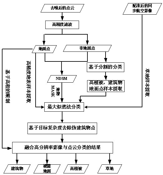
[0030] The invention provides a semi-supervised classification method for airborne lidar data of fusion images. Based on the semi-supervised concept, the rough classification results of point cloud data are used to extract high-precision training sample data for the classification of high-resolution images, and Combining multiple features of LiDAR point cloud for cross-validation, and finally realize the fine classification of airborne LiDAR data.

[0031] The present invention will be further described below with specific embodiments in combination with the drawings:

[0032] The invention provides a semi-supervised classification method of airborne lidar data for fusion of images, including the following steps:

[0033] (1) Denoising of raw lidar data:

[0034] If the point cloud data has extremely low points and aerial points that are significantly lower or higher than the surrounding environment, it will greatly affect the accuracy of the post-processing algorithm, so these noise ...


PUM


Abstract

The invention relates to the technical field of airborne laser radar data processing, in particular to a semi-supervised classification method for airborne laser radar data fusing images. In the method, based on a semi-supervision concept, rough classification results of point cloud data are utilized to extract high-accuracy training sample data which is used for classifying high-resolution images; and in the post-processing process, based on target complexity, spurious building points are removed, the classification results are refined, and LiDAR (Laser Intensity Direction and Ranging) pointcloud multiple characteristics are fused for cross validation so as to finally realize fine classification of airborne laser radar data. The method is a fusion classification method with high reliability and high classification accuracy. In the precondition without using near infrared data, the method achieves good effect of classification for point cloud tall vegetation and low vegetation areas.

Description

Technical field [0001] The invention relates to the technical field of airborne lidar data processing, in particular to an airborne lidar data semi-supervised classification method of fusion images. Background technique [0002] Airborne LiDAR is a new type of active aerial remote sensing earth observation technology, which can directly obtain the spatial 3D point cloud information of the target. With the acceleration of urbanization, the use of airborne LiDAR technology to achieve high-precision and efficient extraction of urban terrain information is of great significance. The most basic and key technology is the classification of LiDAR point cloud data. The points classified as bare ground are used for the generation of digital ground models to provide basic data for topographic mapping, engineering surveys, environmental planning, etc.; the points classified as buildings and vegetation can be used to improve the accuracy of DTM models, and in 3D digital cities. Building mode...

Claims


Application Information

Patent Timeline
Patent Type & Authority Applications(China)
IPC IPC(8): G01S7/48G01S17/89G06K9/62G06K9/36
Inventor 邬建伟钟良马洪超彭检贵
Owner WUHAN UNIV
Why Eureka
Try Eureka