Method and system for map matching of transportation vehicle GPS (Global Position System) data

A GPS data and map matching technology, which is applied in the field of GPS data map matching of traffic vehicles, can solve the problems of inability to match GPS data, low calculation efficiency, and does not consider GPS data positioning errors, etc., to achieve the effect of improving accuracy and improving operation efficiency

Active Publication Date: 2011-08-10
广州通易科技有限公司
View PDF8 Cites 70 Cited by
  • Summary
  • Abstract
  • Description
  • Claims
  • Application Information

AI Technical Summary

Problems solved by technology

The map matching calculation efficiency of the API interface is inversely proportional to the number of road sections in the road traffic network. When matching massive GPS data to roads in a city or a province, the calculation efficiency is very low. For example, only 1,000 GPS data can be completed within 5 minutes. The data points are matched to the road traffic network of Guangdong Province, which cannot meet the requirement of matching 500,000 GPS data to the road traffic network of Guangdong Province within 2 minutes
At the same time, the API interface does not consider the GPS data positioning error. When the position of the GPS data point is at the intersection or parallel position of multiple roads, the GPS data cannot be accurately matched to the road traffic network.

Method used


Image

  • Method and system for map matching of transportation vehicle GPS (Global Position System) data
  • Method and system for map matching of transportation vehicle GPS (Global Position System) data
  • Method and system for map matching of transportation vehicle GPS (Global Position System) data

Examples


Embodiment Construction

[0023] In the following, the technical means adopted by the present invention to achieve the intended purpose of the invention will be further described in conjunction with the accompanying drawings and preferred embodiments.

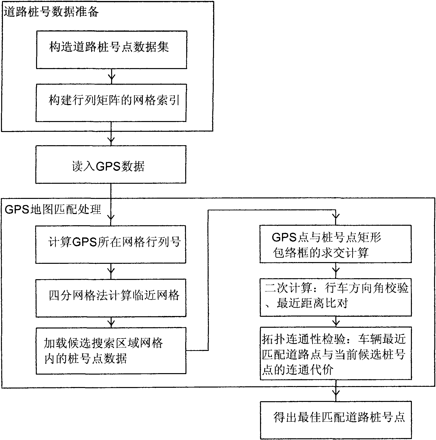
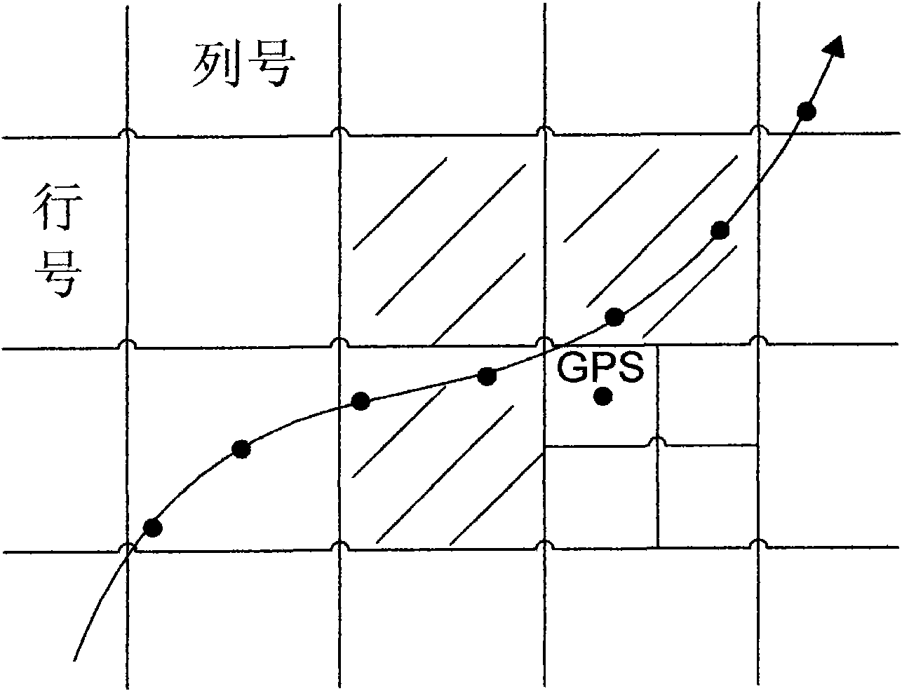
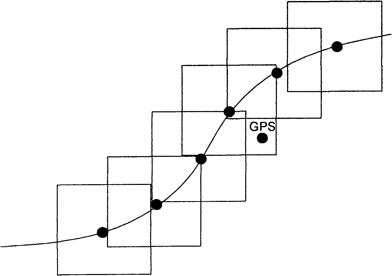
[0024] Such as figure 1 As shown, the present invention is a method and system for GPS data map matching of traffic vehicles, and the implementation conditions include database storage and algorithm programs. It includes the following steps:

[0025] 1.) The road line data with chainage mileage is selected according to the fixed distance interval value, and the following data items of the chainage points are written into the database for storage, including longitude, latitude, mileage chainage value, and road driving direction angle value. To construct the road stake point data, the road can generally be abstracted into two directed line segments with opposite directions. From the starting point of the road to the end point, according to the preset int...


PUM


Abstract

The invention discloses a method and system for map matching of transportation vehicle GPS (Global Position System) data. In the invention, a map matching process of the transportation vehicle GPS data is completed by structuring high-efficiency map matching grid indexes and using a simplified and accurate matching calculation, so that the operation efficiency of matching of the transportation vehicle GPS data is greatly improved, and the processing efficiency is thousands times higher than that of the traditional map matching method; and the matching positioning of a vehicle in a complex road network is assisted and judged by tracking the historical matching road state of the vehicle and using the topological connectivity of the road network, so that the accuracy of the map matching of the transportation vehicle GPS data can be greatly improved.

Description

technical field [0001] The invention relates to a method and system for GPS data map matching of traffic vehicles. Background technique [0002] The GPS data of traffic vehicles is the GPS data collected in real time by traffic vehicles (including buses, taxis, long-distance buses, bulk material vehicles, school buses, dangerous goods transport vehicles, etc.) installed with GPS terminals according to a certain frequency. Send it to the GPS monitoring center through the wireless network. [0003] Traffic vehicle GPS data map matching refers to the calculation and processing process of matching the GPS data collected by traffic vehicles to known roads, and matching with the spatial position data of known roads according to the vehicle's longitude, latitude, and driving direction angle. Degree calculation to get the best matching road of GPS data. The existing traffic vehicle GPS data map matching is usually completed using the API interface of commercial GIS software such a...

Claims


Application Information

Patent Timeline
Patent Type & Authority Applications(China)
IPC IPC(8): G01C21/30
Inventor 蔡文学罗永坚刘锬
Owner 广州通易科技有限公司
Why Eureka
Try Eureka