Method for focusing geo-synchronization orbit synthetic aperture radar in high precision

A technology of synthetic aperture radar and geosynchronous orbit, applied in the direction of radio wave reflection/re-radiation, using re-radiation, measuring devices, etc., can solve problems such as inability to deal with equivalent straight line models, unaccounted for, etc.

Inactive Publication Date: 2011-08-31
BEIJING INSTITUTE OF TECHNOLOGYGY
View PDF3 Cites 22 Cited by
  • Summary
  • Abstract
  • Description
  • Claims
  • Application Information

AI Technical Summary

Problems solved by technology

[0006] The purpose of the present invention is to solve the problem that the traditional LEO SAR algorithm cannot handle the situation that the equivalent straight line model does no...

Method used


Image

  • Method for focusing geo-synchronization orbit synthetic aperture radar in high precision
  • Method for focusing geo-synchronization orbit synthetic aperture radar in high precision
  • Method for focusing geo-synchronization orbit synthetic aperture radar in high precision

Examples


Embodiment

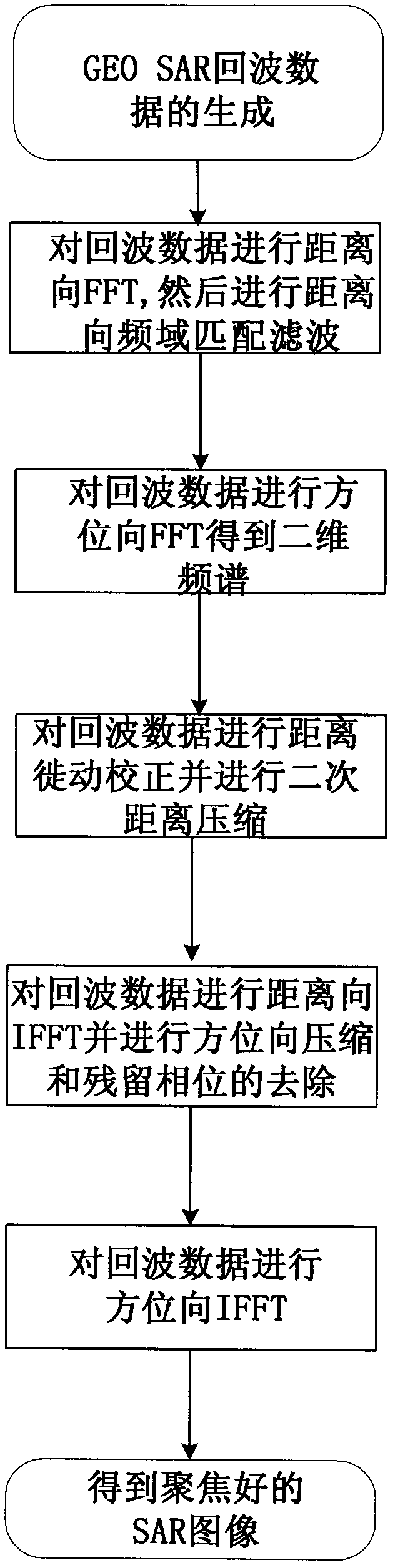
[0065] A high-precision focusing method for synthetic aperture radar in geosynchronous orbit, such as figure 1 As shown, the steps are:

[0066] 1) GEO SAR accurate slant range model modeling and thus get GEO SAR accurate signal model.

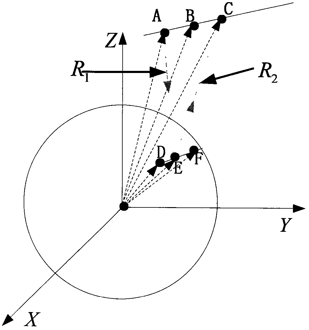
[0067] The key to the GEO SAR signal model is to construct the slant range model. Such as figure 2 As shown, the satellite in the figure is at point A when transmitting the signal, which is recorded as At this point the target is at point D, denoted as When the signal reaches the target, the positions of the satellite and the target are B and E respectively, denoted as and When the signal returns to the satellite, the satellite position is at point C, and the position coordinates are The position of the target is point F, and the coordinates are according to figure 2 , write the GEO SAR two-way slope distance as

[0068] R n = R 1 + ...


PUM


Abstract

The invention relates to a method for focusing a geo-synchronization orbit synthetic aperture radar (GEO SAR) in high precision, and belongs to the technical field of radar signal processing. An error of a 'Stop-and-Go' supposition is taken into consideration and applied to a deduction process of an algorithm. Aiming at the problem that a typical low earth orbit synthetic aperture radar (LEO SAR) algorithm cannot process a false equivalent linear model, a norm is adopted to express an inclined distance and high-precision approximation is executed. By the method, the imaging precision is high; the method is applicable to imaging at an ultralong synthetic aperture time; high distance migration and boundedness of the equivalent linear model are overcome; and the problem that the LEO SAR imaging algorithm cannot process the 'Stop-and-Go' supposition is solved.

Description

technical field [0001] The invention relates to a geosynchronous orbit synthetic aperture radar (GEO SAR) high-precision focusing method, which belongs to the technical field of radar signal processing. Background technique [0002] The current Synthetic Aperture Radar (SAR) satellites are all low-orbit satellites, and the orbital height does not exceed 1000km. The repeated observation period for a specific area is generally 3 to 5 days, and at least 1 day is required for orbital maneuvering; therefore, low Orbital SAR has the problems of low time resolution and long lag time to deal with emergencies. For example, after the Wenchuan Earthquake, the first batch of synthetic aperture radar images was obtained by Japanese and Italian satellites more than a day later, while my country's SAR satellites obtained relevant images two days later, and failed to provide the most timely information for disaster relief work. information service. The solution to this problem is Geosynchr...

Claims


Application Information

Patent Timeline
IPC IPC(8): G01S7/41G01S13/90
Inventor 胡程曾涛龙腾刘志鹏
Owner BEIJING INSTITUTE OF TECHNOLOGYGY
Why Eureka
Try Eureka