A method of combining svm and lidar to detect unstructured road boundaries

An unstructured and lidar technology, applied in the direction of instrumentation, computing, character and pattern recognition, etc., can solve problems that are not suitable for unstructured road boundary detection, and overcome the shortcomings of visual road detection, high accuracy rate, and algorithm good robustness

Active Publication Date: 2011-12-07
NANJING UNIV OF SCI & TECH
View PDF2 Cites 43 Cited by
  • Summary
  • Abstract
  • Description
  • Claims
  • Application Information

AI Technical Summary

Problems solved by technology

[0005] The methods mentioned in the above patents are only suitable for structured roads, not suitable for boundary detection of unstructured roads

Method used


Image

  • A method of combining svm and lidar to detect unstructured road boundaries
  • A method of combining svm and lidar to detect unstructured road boundaries
  • A method of combining svm and lidar to detect unstructured road boundaries

Examples


Embodiment Construction

[0020] specific implementation plan

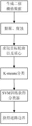
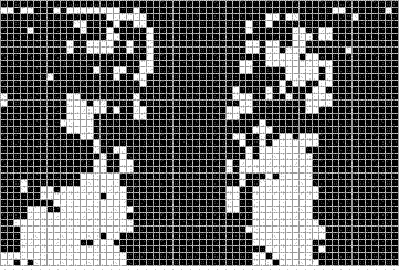
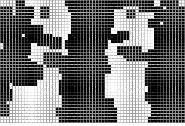
[0021] A method for detecting unstructured road boundaries in combination with SVM and laser radar of the present invention is to analyze and process the data collected by the vehicle-mounted 64-line laser radar during the driving process of an intelligent vehicle to generate binary grid data; Expand and corrode the grid data to make the representation of obstacles as connected as possible; in order to reduce the amount of processing data, obtain the contour of the obstacle target, record these contour points and calculate the center of mass; then use the K-means algorithm to calculate the obstacle The material center is used to classify the target objects into two categories; the contour points of the two types of targets can be trained by SVM to obtain the road boundary. combine figure 1 , including the following steps:

[0022] Step 1. Install a 64-line laser radar on the top of the vehicle, calibrate the radar and collect the three-d...


PUM


Abstract

The invention discloses a method for detecting an unstructured road boundary on which an intelligent vehicle runs. The method comprises the following steps of: analyzing and processing frame data of a vehicle-mounted 64 line laser radar to obtain frame two-value raster data, expanding and corroding the frame two-value raster data to fill small space between data of barriers on the same side of a road and keeping the whole outline unchanged; solving the outline of each barrier target, storing in a chain code mode and solving the mass center of the outline; performing K means clustering on the barrier targets, wherein a sample is the solved mass center, the targets comprise barrier targets on the left side of the road and barrier targets on the right side of the road; and training by using a support vector machine (SVM), wherein the sample is the outline points of the classified barrier targets, thus obtaining a classifier, and finally solving a straight line section which describes theroad boundary according to the classifier, the maximum interval conditions and the raster data. In the method, data involved in calculation is reduced as much as possible; and the method is high in real-time property, and the solved road boundary accuracy rate is high.

Description

technical field [0001] The invention relates to a method for detecting the boundary of an unstructured road where an intelligent vehicle is running, in particular to a method for detecting the boundary of an unstructured road in combination with SVM (support vector machine) and laser radar. Background technique [0002] Most of the research on the perception and understanding of driving roads in intelligent vehicle navigation technology is based on images. The image of the road ahead is collected by the camera installed directly above the intelligent vehicle, and then the road boundary information is extracted by image processing. When intelligent vehicles drive on structured roads, the road boundary information is very obvious and easy to extract, while on unstructured roads, the road environment is very complex, mainly in the following aspects: (1) There are various road surface coverings, which may It is dirt, sand, asphalt and cement; (2) The width of the road varies gr...

Claims


Application Information

Patent Timeline
Patent Type & Authority Applications(China)
IPC IPC(8): G06K9/62G06K9/00
Inventor 唐振民陆建峰诸葛程晨
Owner NANJING UNIV OF SCI & TECH
Why Eureka
Try Eureka