Car navigation device and method

A car navigation device and car navigation technology, applied in the field of car navigation devices, can solve problems such as danger, inability to immediately remind the driver, driving to the wrong path, etc.

Active Publication Date: 2011-12-14
MOBILE DRIVE NETHERLANDS BV
View PDF5 Cites 20 Cited by
  • Summary
  • Abstract
  • Description
  • Claims
  • Application Information

AI Technical Summary

Problems solved by technology

However, drivers often observe the route indication directions on the navigation screen, which will cause them to fail to pay attention to the real-time road conditions for a period of time
Or listen to real people's simulated voice prompts, although it can prevent the line of sight from leaving the front of the vehicle, but these functions are to inform the direction of the planned route in advance, and if the driver chooses the wrong route, the navigation device must receive GPS satellite signals and process them before driving. Remind the driver, the function of reminding th

Method used


Image

  • Car navigation device and method
  • Car navigation device and method
  • Car navigation device and method

Examples


Embodiment Construction

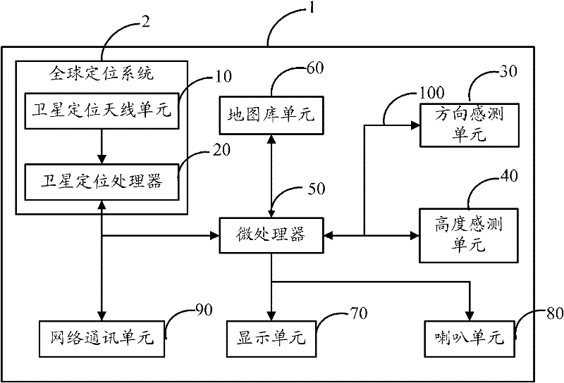
[0014] Such as figure 1 Shown is the architecture diagram of the preferred embodiment of the car navigation device of the present invention. The car navigation device 1 includes a global positioning system 2, a direction sensing unit 30, a height sensing unit 40, a microprocessor 50, a map library unit 60, a display unit 70, a speaker unit 80 and a network communication unit 90, and a microprocessor 50 is connected to the above-mentioned components through a bus 100. The global positioning system 2 includes a satellite positioning antenna unit 10 and a satellite positioning processor 20.

[0015] The satellite positioning antenna unit 10 receives satellite signals transmitted by at least four GPS positioning satellites in space by communicating with GPS positioning satellites, and transmits the signals to the satellite positioning processor 20.

[0016] The satellite positioning processor 20 calculates the distance D between the vehicle and the GPS positioning satellite according ...


PUM


Abstract

A vehicle navigation method, comprising the following steps: receiving the current position information of the vehicle from a satellite positioning processor, and connecting to a network communication unit to receive the current position information of the vehicle if there is no satellite signal; generating a planned route according to the current position of the vehicle, map information and destination; Judging whether the distance between the current position of the vehicle and the nearest bifurcation point in front of the planned path is less than the preset distance, if not, return to the step of receiving the current position information of the vehicle; the direction sensing unit and the height sensing unit sense and record Vehicle driving direction and height change; compare whether the direction and height change information is the same as the direction and height information of the correct path, and send a warning message if they are not the same. The invention also provides a vehicle navigation device. The present invention can provide critical and real-time path direction and height change judgments, so as to prevent drivers from driving to wrong paths at critical path bifurcation points.

Description

Technical field [0001] The invention relates to a navigation device and method, in particular to a vehicle navigation device and method. Background technique [0002] With the continuous innovation and progress of technology, the installation of GPS (Global Positioning System) navigation devices on the car has become one of the habits of ordinary drivers. The GPS navigation device receives satellite signals transmitted by GPS positioning satellites in space, and displays the real-time position of the vehicle in the navigation software of the navigation device according to the satellite signals, so as to realize the navigation function of the road. However, because GPS navigation uses the signals emitted by multiple satellites to locate the driver’s current geographic location (usually expressed in longitude and latitude), if you encounter poor satellite signal reception (such as bad weather, When there is an elevated road in the valley or above the road), the GPS navigation devi...

Claims


Application Information

Patent Timeline
IPC IPC(8): G01C21/28G01C21/36
Inventor 陶圣辉
Owner MOBILE DRIVE NETHERLANDS BV
Why Eureka
Try Eureka