Monitoring and prewarning system and method for geological disasters

A technology for monitoring and early warning of geological disasters, applied in the field of surface survey, can solve the problems of inaccurate and timely prediction and forecasting of geological disasters, and achieve the effect of solving difficult power supply, large capacity, and long transmission distance

Inactive Publication Date: 2012-02-15
河北省第一测绘院
View PDF2 Cites 76 Cited by
  • Summary
  • Abstract
  • Description
  • Claims
  • Application Information

AI Technical Summary

Problems solved by technology

[0005] One of the purposes of the present invention is to provide a geological disaster monitoring and early warning system to establish a set of geological disaster early warning an

Method used


Image

  • Monitoring and prewarning system and method for geological disasters
  • Monitoring and prewarning system and method for geological disasters
  • Monitoring and prewarning system and method for geological disasters

Examples


Embodiment Construction

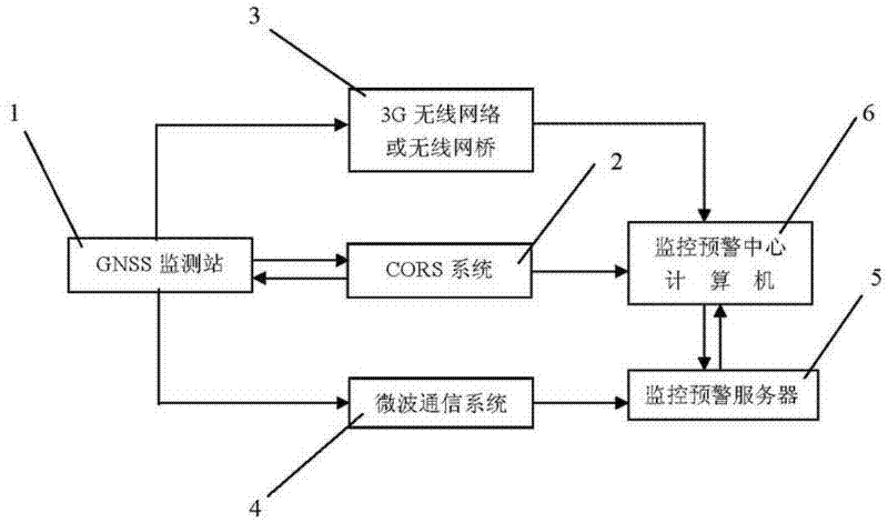
[0053] Such as figure 1 As shown, the geological disaster monitoring and early warning system of the present invention includes: several GNSS monitoring stations 1, CORS system 2, 3G wireless network or wireless network bridge 3, microwave communication system 4, monitoring and early warning server 5 and monitoring and early warning center distributed in the monitored area Computer 6 etc. Among them, CORS system 2 and microwave communication system 4 all borrow the CORS system and microwave communication system for public service in the area; 3G wireless network or wireless bridge 3 is the wireless communication network established by the mobile communication department in the area; monitoring and early warning server 5 itself is a common server, because it is arranged in the monitoring and early warning center and connected with the Internet, it is called a monitoring and early warning server.

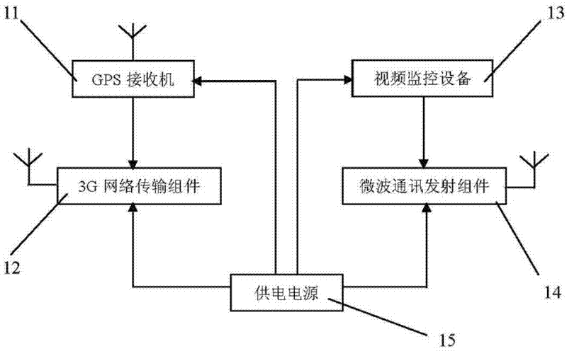
[0054] Such as figure 2 As shown, each GNSS monitoring station 1 includes: a G...


PUM


Abstract

The invention relates to a monitoring and prewarning system and a monitoring and prewarning method for geological disasters. The monitoring and prewarning system for the geological disasters comprises a plurality of global navigation satellite system (GNSS) monitoring stations 1, a continuous operational reference system (CORS) 2, a 3rd-generation (3G) wireless network or wireless bridge 3, a microwave communication system 4, a monitoring and prewarning server 5, a monitoring and prewarning central computer 6 and the like which are arranged in a monitored area. Each GNSS monitoring station 1 comprises a global positioning system (GPS) receiver 11, a 3G network transmission component 12, video monitoring equipment 13, a microwave communication transmission component 14, a power supply 15 and the like. In the method, the aims of forecasting and prewarning possibly initiated geological disasters automatically in real time can be fulfilled by setting the GNSS monitoring stations in areas liable to the geological disasters, monitoring ground surface displacement in real time by the CORS, performing real-time ground surface displacement monitoring on the geological disasters, such as collapse, landslide, debris flow, surface collapse, subsidence, ground fissure and the like, which can be caused by ground surface displacement, combining remote video monitoring, performing data processing on monitoring information, and automatically issuing prewarning information.

Description

technical field [0001] The invention relates to a surface survey technology, in particular to a geological disaster monitoring and early warning system and a monitoring and early warning method. Background technique [0002] In recent years, due to abnormal changes in the global climate, the hidden dangers of geological disasters are also increasing; especially with the intensification of human activities and the continuous expansion of the scope of activities, more and more geological damages are caused. my country has a vast territory and a vast land area, and the natural geological environment conditions that breed geological disasters are complex and changeable, with strong natural variations. Due to the different nature and intensity of human activities in different regions, the types, development intensity and damage of geological disasters are very different. It has become one of the countries with frequent geological disasters in the world. The threat of geological ...

Claims


Application Information

Patent Timeline
IPC IPC(8): G08B21/10G08B25/00G01V1/00
Inventor 高献计许国振陈群国陈永立李永华种占学李军华孟祥光潘伟峰
Owner 河北省第一测绘院
Why Eureka
Try Eureka