Geographic information database management method and system

A geographic information data and management system technology, applied in the field of geographic information database management methods and systems, can solve problems such as application development constraints, difficult application environments for spatial data database building software, and difficulty in functioning, so as to meet the requirements of data sharing and exchange requirements, avoid duplication of development and maintenance, and improve work efficiency

Inactive Publication Date: 2012-04-04
FOUNDER INTERNATIONAL CO LTD +1
View PDF4 Cites 30 Cited by
  • Summary
  • Abstract
  • Description
  • Claims
  • Application Information

AI Technical Summary

Problems solved by technology

[0005] 2. The storage form is fixed: limited by the platform, the storage form of spatial data is usually fixed
[0006] 3. The function design is loose, the flow is not strong, and the design of general database building tools has no clear pertinence
[0010] 1. Rely on a specific GIS platform: Existing database building tools usually only support their own GIS platforms, while police systems have complex and diverse application environments, and it is impossible to be limited to a single GIS platform
[0011] 2. The storage form of spatial data is single and fixed: the GIS data storage form of the police system is various, both in the form of database and in the form of files, and the types of spatial databases include both foreign and domestic manufacturers, so a strong adaptability is required database builder manages its data
[0012] 3. Lack of pertinence: The police system has its own characteristics in terms of layer standards, data organization, and management. The existing spatial data database construction software is difficult to fully adapt to its application environment, making it difficult to play a role in daily work. Unable to provide support for the development of the upper application system
[0013] 4. Lack of support for standards: Existing database building tools lack a complete set of support for standard management before data storage, causing them to often focus on the loading and management of the data itself
However, in the police environment, the data sources are complex and diverse. Without the support of a standardized system, it will be difficult to meet various application needs in the future.
[0014] The above shortcomings make these database building software not fully suitable for the construction requirements of the police geographic information database, and the database management mechanism has not been unified, which restricts the development of various applications based on the police platform.

Method used


Image

  • Geographic information database management method and system
  • Geographic information database management method and system
  • Geographic information database management method and system

Examples


Embodiment Construction

[0057] The present invention will be described in detail below in conjunction with the accompanying drawings.

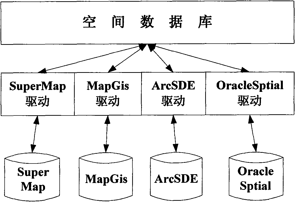
[0058] Such as figure 1As shown, the geographic information data management system embodiment of the present invention includes:

[0059] Spatial database for storing geographic information data of different GIS platforms;

[0060] GIS platform, for storing or obtaining geographical information data to described spatial database, for example: SuperMap, MapGis, ArcSDE and OracleSptial platform etc.;

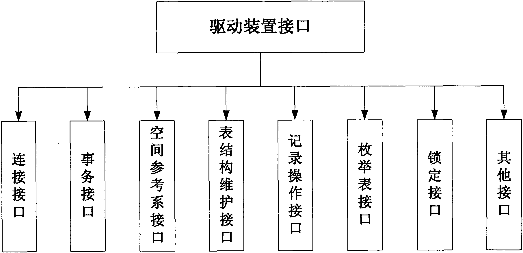
[0061] The driving device is arranged between different GIS platforms and spatial databases, and is used to receive the geographical information data of the GIS platform, and send it to the spatial database after format conversion; or obtain the required information of the GIS platform from the spatial database. The geographic information data is forwarded to the GIS platform after its format is converted into a format corresponding to the GIS platform, such as the Sup...


PUM


Abstract

The invention discloses a geographic information data management method and a geographic information data management system. The geographic information data management system comprises spatial databases, geographic information system (GIS) platforms and driving devices, wherein the spatial databases are used for storing geographic information data of different GIS platforms; the GIS platforms are used for storing the geographic information data in the spatial databases or acquiring the geographic information data from the spatial databases; and the driving devices are arranged between the different GIS platforms and the spatial databases and used for receiving the geographic information data of the GIS platforms, performing format conversion and sending the geographic information data subjected to format conversion to the spatial databases, or acquiring the required geographic information data of the GIS platforms from the spatial databases, performing format conversion to obtain formats corresponding to the GIS platforms and forwarding the geographic information data subjected to format conversion to the GIS platforms. By the geographic information data management method and the geographic information data management system, the spatial databases in the different GIS platforms are subjected to unified and standardized management and are prevented from being repeatedly developed or maintained, the construction cost of the GIS platforms is reduced, and work efficiency is improved.

Description

technical field [0001] The invention relates to a database technology, in particular to a geographic information database management method and system. Background technique [0002] Spatial database is the sum of application-related geospatial data stored by geographic information system on computer physical storage medium, and is generally organized on storage medium in the form of a series of files with specific structure. The research on spatial databases began in the field of cartography and remote sensing image processing in the 1970s, with the purpose of effectively using satellite remote sensing resources to quickly draw various economic thematic maps. Due to the many defects in the representation, storage, management and retrieval of spatial data in the traditional relational database, the database research field of spatial database has been formed. However, traditional database systems only aim at simple objects and cannot effectively support complex objects (such ...

Claims


Application Information

Patent Timeline
Patent Type & Authority Applications(China)
IPC IPC(8): G06F17/30
Inventor 李欣王生李强毛定山
Owner FOUNDER INTERNATIONAL CO LTD
Why Eureka
Try Eureka