System and method for controlling fixed-height flight of fixed-wing unmanned aerial vehicle

A technology of flight control system and fixed-wing unmanned aerial vehicle, which is applied in the direction of control start-up method and automatic manipulation, etc., which can solve the problems of complicated use, easy to be affected by weather changes, unsuitable for small unmanned aerial vehicles, etc., and achieve convenient control Effect

Inactive Publication Date: 2012-05-09
BEIJING UNIV OF TECH
View PDF8 Cites 25 Cited by
  • Summary
  • Abstract
  • Description
  • Claims
  • Application Information

AI Technical Summary

Problems solved by technology

Due to the instability of GPS received data, it is greatly affected by external interference, such as the height of surrounding buildings, terrain factors, etc., and the number of received satellites often changes, which will lead to drastic jumps in height measurement, which requires a lot of data processing to minimize The error is small, and the stability is still unsatisfactory, and its cost is high, the volume is large, and it is not suitable for small drones to fly at a fixed altitude
The patent application number is 200810102821.0, and the patent application titled "A Method for Automatic Correction of Radio Altimeter Altitude and Lifting Speed ​​of UAV" discloses a method of using a radio altimeter to measure altitude and control it. The accuracy of the radio altimeter can meet Flight requirements, but the use is relatively complicated, it is necessary to add antennas to both the UAV and the ground station, and its cost is relatively high, not suitable for small UAVs
The pressure sensor overcomes many shortcomings of GPS, and has been optimized in terms of accuracy, cost, and volume. At the same time, it also has the advantage of being easy to use, but it is susceptible to weather changes

Method used


Image

  • System and method for controlling fixed-height flight of fixed-wing unmanned aerial vehicle
  • System and method for controlling fixed-height flight of fixed-wing unmanned aerial vehicle
  • System and method for controlling fixed-height flight of fixed-wing unmanned aerial vehicle

Examples


Embodiment Construction

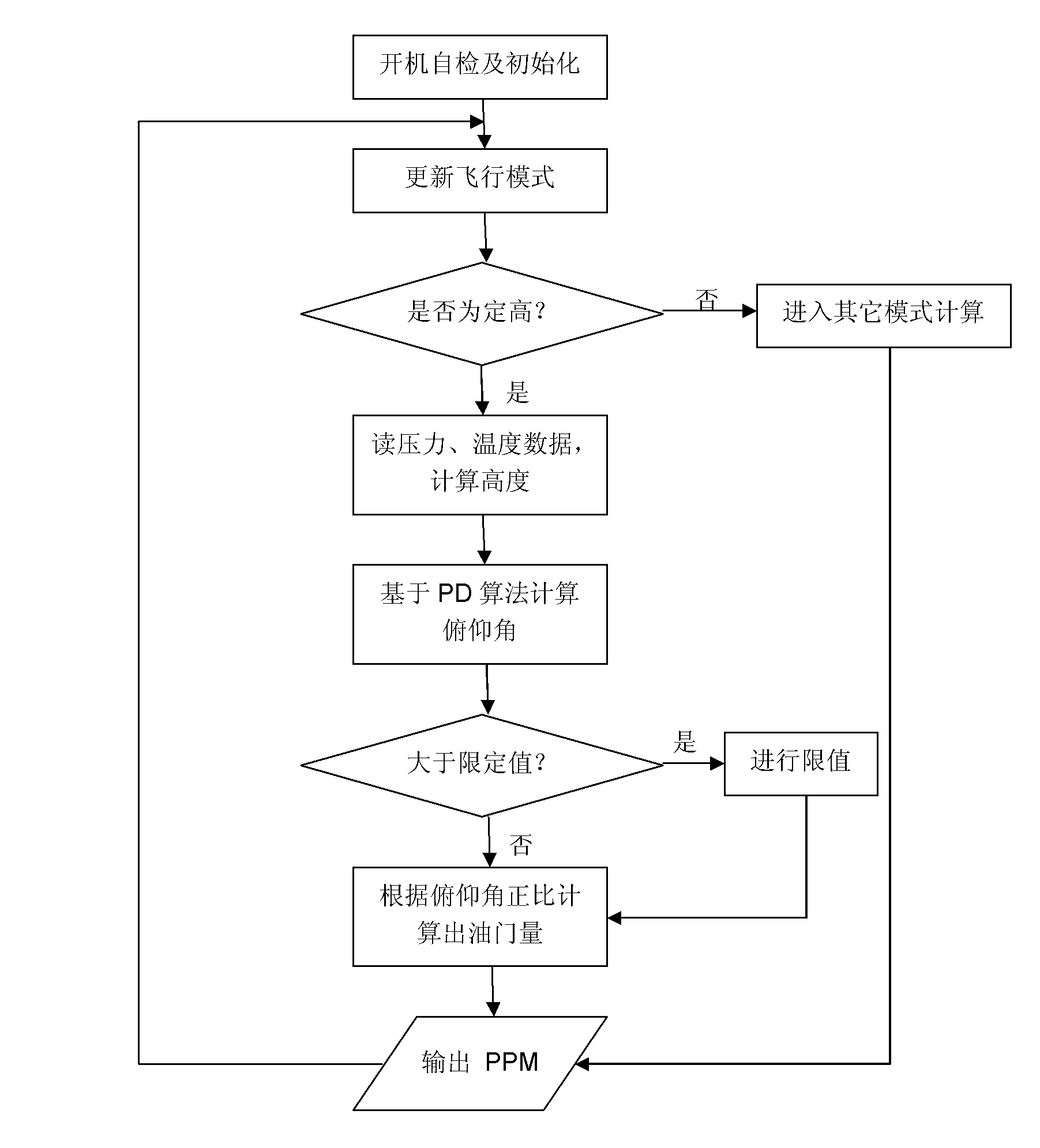
[0035] Below in conjunction with accompanying drawing and specific embodiment the present invention will be further described:

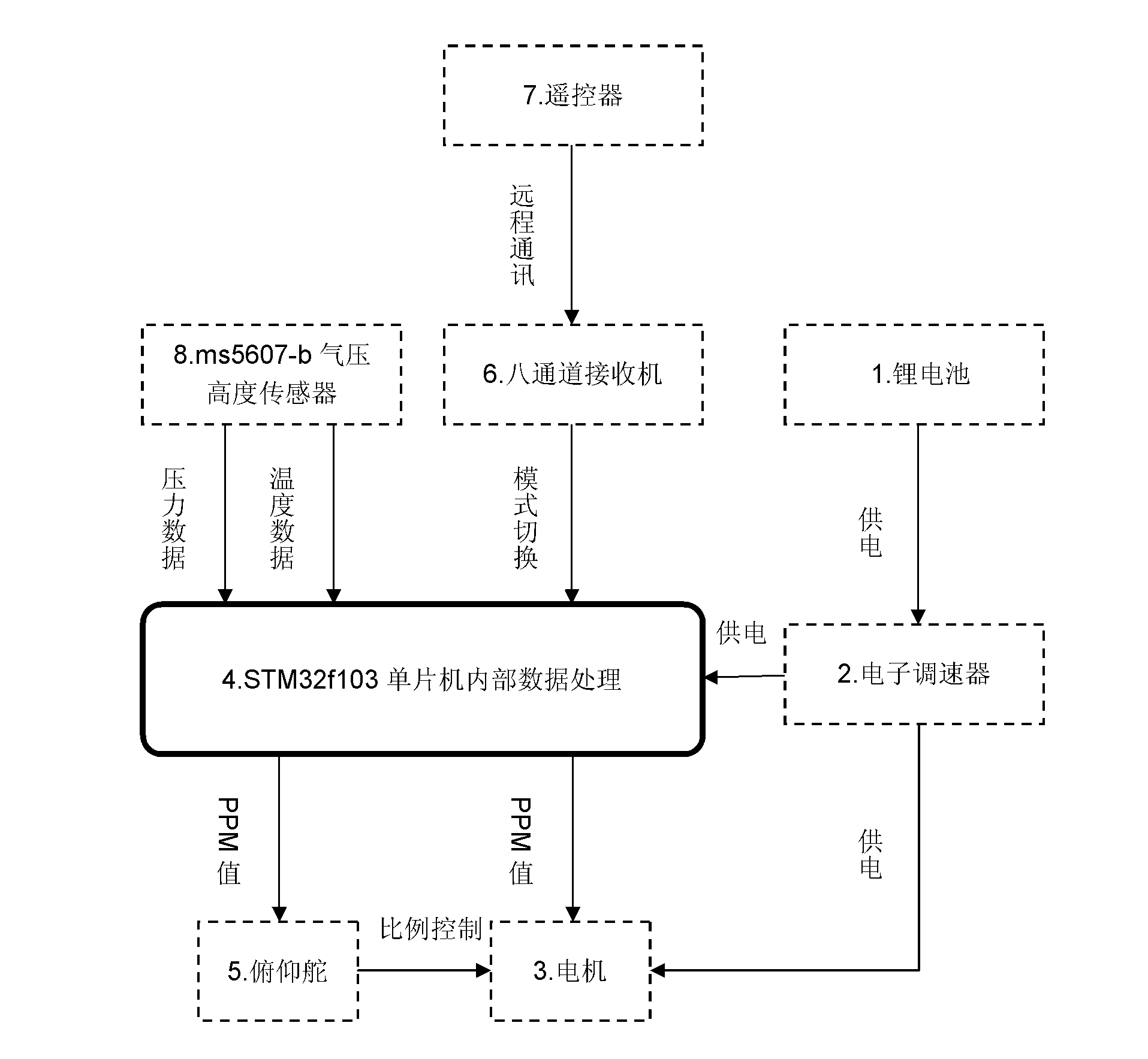
[0036] The flight system includes fixed-wing drones, sensor modules, and control circuits. As the physical carrier of the whole system, the fixed-wing unmanned aerial vehicle, the sensor module measures the current position, attitude and height information of the unmanned aerial vehicle in real time, and sends it to the control circuit, and then performs data calculation through the single-chip microcomputer in the control circuit, and sends the calculated result to the The motor and steering gear are controlled.

[0037] Fixed-wing drones: such as figure 1 As shown, it includes a power supply 1, an electronic speed controller 2, a motor 3, an elevator 5, a receiver 6, and a remote controller 7. The power supply 1 is connected to the electronic speed controller 2, and the power wire, signal wire and ground wire drawn from the electronic speed cont...


PUM


Abstract

The invention discloses a system and a method for controlling fixed-height flight of a fixed-wing unmanned aerial vehicle, relating to the field of unmanned aerial vehicle control. By using the system and the method, a barometric height sensor is used as a height measuring element, an external lithium battery is used for supplying power to the whole system, and the sensor is protected by using a wind filtering device to reduce the influence, caused by wind pressure at a high altitude, on the sensor so that errors are reduced. After related information is measured by the barometric height sensor, an I2C bus (internal integrated circuit bus) transmits data to a single-chip microcomputer system, a series of data calculations are performed in a single-chip microcomputer to obtain corresponding height information; and finally, an elevating rudder and a gasoline throttle on the plane are linked together for PD (proportional plus derivative) control so as to control angle changes of a steering engine and the size of the gasoline throttle, and a height over-ascending and over-descending protection program is added in the programs to further improve the safety and realize autonomous height fixing of the unmanned aerial vehicle. The system has the advantages of low cost, small error, stable structure, small interference from external environment, easy implementation and the like.

Description

technical field [0001] The invention relates to the field of control of unmanned aerial vehicles, and is specifically applied to the technology of fixed-altitude flight of unmanned aerial vehicles. Background technique [0002] UAV technology has entered a period of comprehensive development, and has become increasingly mature in terms of navigation, but in terms of flight altitude, it is only to measure the height, there is no low-cost and mature fixed-wing UAV fixed-altitude flight method, and the fixed-altitude flight It is very important for novices to fly, it can effectively avoid accidents such as bombing, and it can also greatly enhance the stability of image shooting during the aerial photography of the camera. [0003] Current methods for determining altitude include GPS to measure altitude, radio altimeter to measure, and pressure sensor to measure altitude. Due to the instability of GPS received data, it is greatly affected by external interference, such as the h...

Claims


Application Information

Patent Timeline
Patent Type & Authority Applications(China)
IPC IPC(8): B64C13/16
Inventor 左国玉王恺李晓伟朱晓庆刘湘
Owner BEIJING UNIV OF TECH
Why Eureka
Try Eureka