Multi-temporal imaging island shoreline surveying method
A multi-temporal, island-based technology, applied in photogrammetry/video surveying, measuring devices, surveying and navigation, etc., can solve problems such as heavy workload, low geometric correction accuracy, slow interpretation speed, etc., to improve extraction efficiency and the effect of extraction accuracy
- Summary
- Abstract
- Description
- Claims
- Application Information
AI Technical Summary
Problems solved by technology
Method used
Image
Examples
Embodiment Construction
[0042] The specific implementation manners of the present invention will be further described in detail below in conjunction with the accompanying drawings and embodiments. The following examples are used to illustrate the present invention, but are not intended to limit the scope of the present invention.
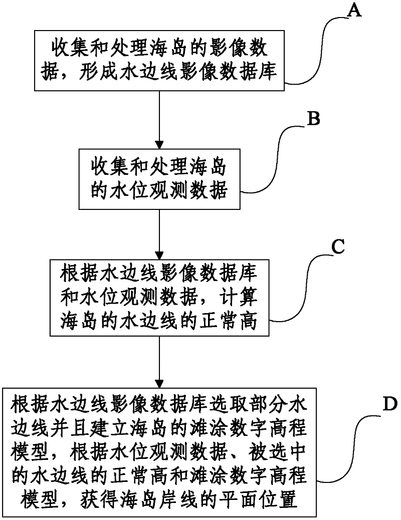
[0043] figure 1 It is a flow chart of the island shoreline measurement method of the multi-temporal image of the present invention. Such as figure 1 As shown, the method includes:
[0044] Step A: Collect and process the image data of the island to form a waterside image database. Described step A specifically comprises:
[0045] Step A1: Collect multi-temporal and high-resolution multi-source image data of the island. The multi-source image data includes: at least two of aerial image data, aerospace image data, optical image data and radar image data. In this embodiment, the high resolution means that the resolution is less than or equal to 2m.
[0046] Step A2: Co...
PUM
 Abstract
Description
Claims
Application Information
 - R&D
- Intellectual Property
- Life Sciences
- Materials
- Tech Scout
- Unparalleled Data Quality
- Higher Quality Content
- 60% Fewer Hallucinations
Browse by: Latest US Patents, China's latest patents, Technical Efficacy Thesaurus, Application Domain, Technology Topic, Popular Technical Reports.
© 2025 PatSnap. All rights reserved.Legal|Privacy policy|Modern Slavery Act Transparency Statement|Sitemap|About US| Contact US: help@patsnap.com


