Water loss and soil erosion remote-sensing dynamic monitoring method based on modified universal soil loss equation

A dynamic monitoring and remote sensing technology, applied in special data processing applications, instruments, electrical digital data processing, etc., can solve the problems of difficult data acquisition, inability to obtain large-scale soil erosion information, unobjective soil erosion, etc., to achieve reduction effect of difficulty

Inactive Publication Date: 2012-07-25
ZHEJIANG UNIV
View PDF1 Cites 28 Cited by
  • Summary
  • Abstract
  • Description
  • Claims
  • Application Information

AI Technical Summary

Problems solved by technology

[0011] Due to the difficulty of obtaining data, the existing methods can only obtain the amount of soil erosion through field measurement in a small area. If it is in a large area, the amount of soil erosion obtained is not object

Method used


Image

  • Water loss and soil erosion remote-sensing dynamic monitoring method based on modified universal soil loss equation
  • Water loss and soil erosion remote-sensing dynamic monitoring method based on modified universal soil loss equation
  • Water loss and soil erosion remote-sensing dynamic monitoring method based on modified universal soil loss equation

Examples


Embodiment Construction

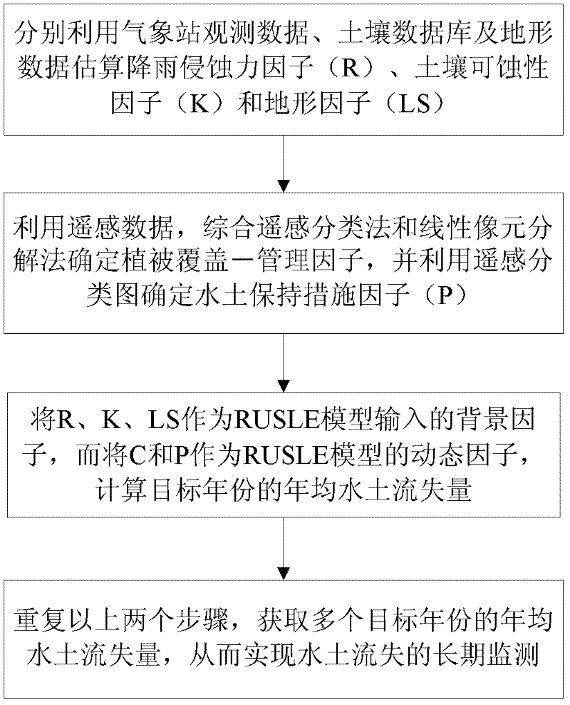
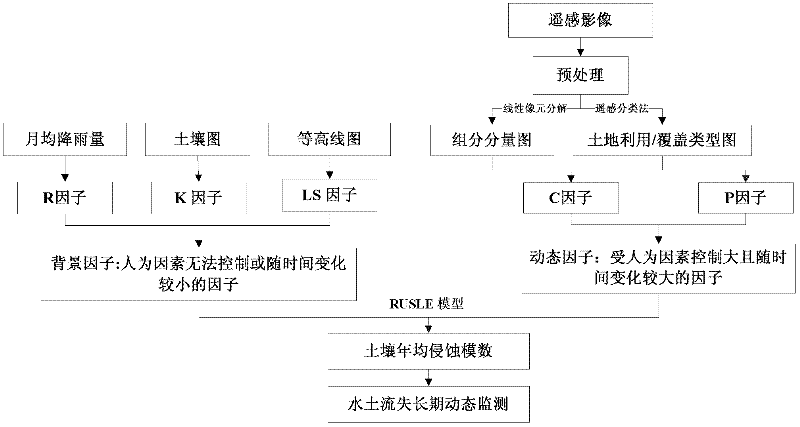
[0058] like figure 1 and figure 2 As shown, the implementation steps of the soil erosion remote sensing dynamic monitoring method based on the modified universal soil erosion equation in this embodiment are as follows:

[0059] 1) Obtain the monthly rainfall data during the specified period of the area to be monitored, and perform spatial regression calculation on the monthly rainfall data and the three-dimensional coordinates of altitude, longitude and latitude to obtain the rainfall erosivity factor (R);

[0060] The soil erodibility factor (K) is calculated according to the soil organic carbon content and soil particle distribution in the large-scale soil spatial database of the area to be monitored;

[0061] The terrain factor (LS) is calculated according to the digital terrain model data of the area to be monitored;

[0062] 2) Obtain the remote sensing image of the area to be monitored; divide the land use / cover category according to the remote sensing image to obtain...


PUM


Abstract

The invention discloses a water loss and soil erosion remote-sensing dynamic monitoring method based on a modified universal soil loss equation, which includes the implementation steps: 1) acquiring a rainfall erosivity factor, a soil erodibility factor and a terrain factor; 2) acquiring remote sensing images of a to-be-monitored area, performing land use/coverage category division according to the remote sensing images to obtain multiple land categories, and respectively estimating a vegetation coverage-management factor of each land category so as to obtain a comprehensive vegetation coverage-management factor; 3) extracting characteristic information affecting water and soil conservation from the remote sensing images, and estimating a water and soil conservation measure factor according to the characteristic information affecting water and soil conservation; and 4) calculating an average annual soil loss amount estimated value of the to-be-monitored area according to the modified universal soil loss equation, and outputting the value. The water loss and soil erosion remote-sensing dynamic monitoring method based on the modified universal soil loss equation has the advantages of reasonable estimated result, high universality, suitability for long-term dynamic monitoring of water loss and soil erosion in the area and wide application range.

Description

technical field [0001] The invention relates to the field of water and soil loss risk assessment, in particular to a remote sensing dynamic monitoring method for water and soil loss based on a modified general water and soil loss equation. Background technique [0002] Soil erosion refers to the movement of soil out of the soil due to water erosion or wind force, resulting in a decline in soil fertility, serious or even complete loss of soil fertility. The demise of the ancient Babylonian kingdom was caused by soil erosion and environmental damage. In the early 1930s, serious soil erosion also occurred in the United States. However, the government, all social strata and the public have attached great importance to it and taken strong soil and water conservation measures, which have well controlled soil erosion. Soil erosion is very serious in our country. The Yellow River Basin is the most obvious example. Huge sediment flows from the Gobi, grasslands, and Loess Plateau i...

Claims


Application Information

Patent Timeline
IPC IPC(8): G06F19/00
Inventor 吴嘉平江振蓝苏世亮
Owner ZHEJIANG UNIV
Why Eureka
Try Eureka