Remote monitoring method for soil moisture of wheat field

A technology of remote sensing monitoring and soil moisture, which is applied in the field of remote sensing monitoring of soil moisture in wheat fields, and can solve the problems of reduced accuracy of model inversion, low vegetation coverage, and decreased monitoring accuracy of thermal inertia models

Inactive Publication Date: 2012-08-08
SHANDONG AGRI SUSTAINABLE DEV INST
View PDF0 Cites 21 Cited by
  • Summary
  • Abstract
  • Description
  • Claims
  • Application Information

AI Technical Summary

Problems solved by technology

When the farmland is bare land, the MODIS image can truly reflect the spectral characteristics of the surface soil; when the vegetation coverage gradually increases, affected by the canopy effect of plant leaves, the performance of the surface soil characteristics on the satellite image is disturbed, and the accuracy of the model inversion significantly reduce
During the wheat cultivation process, the soil coverage of the field is cha...

Method used


Image

  • Remote monitoring method for soil moisture of wheat field
  • Remote monitoring method for soil moisture of wheat field
  • Remote monitoring method for soil moisture of wheat field

Examples


Embodiment

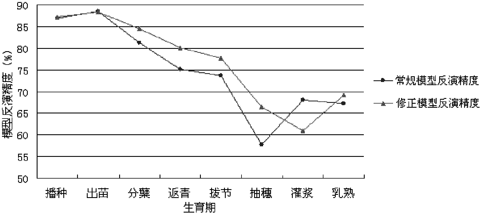
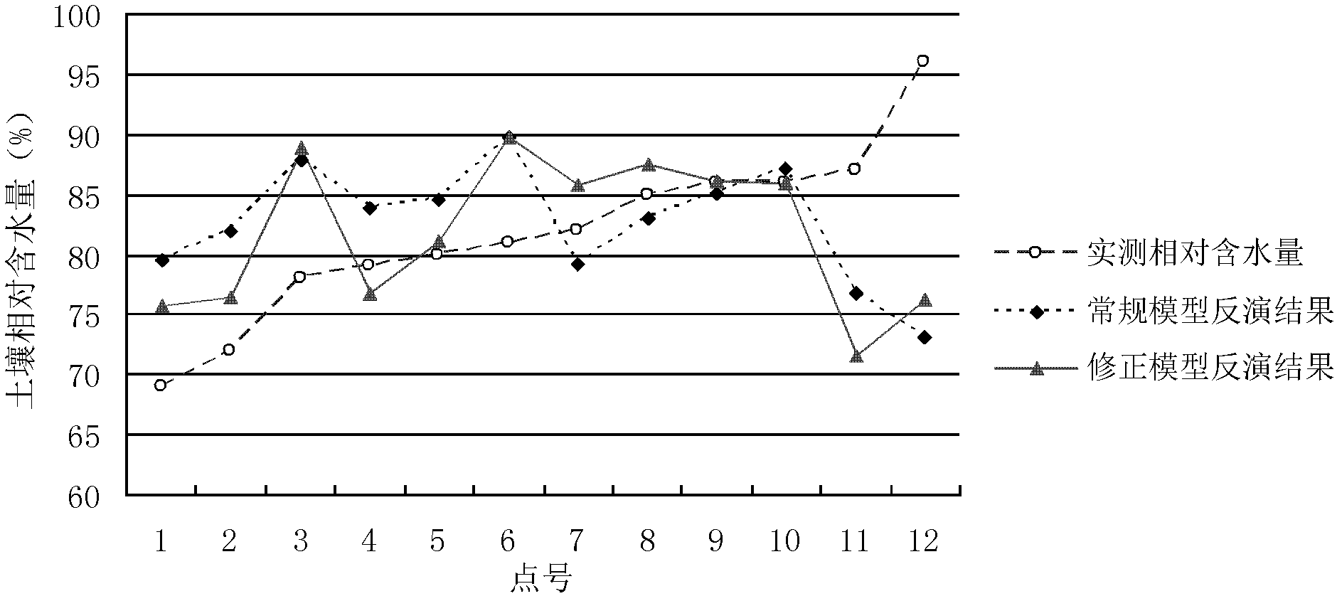
[0044] From the perspective of wheat growth and development process, the present invention considers the canopy effect formed by the wheat plants in the farmland before ridge closure on the inversion of soil thermal inertia, and tries to introduce the vegetation index into the conventional thermal inertia model. Existing research results have shown that EVI (Enhanced Vegetation Index) can better describe the time difference of vegetation in different seasons in a certain area, and EVI can better eliminate the influence of soil background in low vegetation coverage areas, so EVI is selected as the The vegetation influence factor is introduced into the model, and the revised thermal inertia model is obtained:

[0045] W=B 1 ×ATI+B 2 ×EVI+B;

[0046] In the formula, W is the relative water content of the soil; ATI is the apparent thermal inertia; B 1 , B 2 is the coefficient term; EVI is the enhanced vegetation index; B is the constant term.

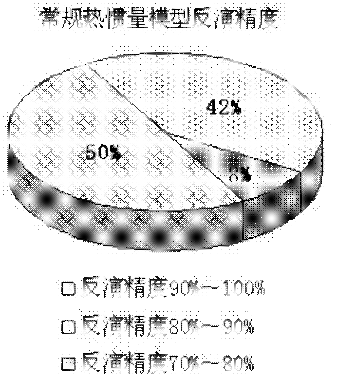
[0047] (1) Parameter inversion ...


PUM


Abstract

The invention discloses a remote monitoring method for soil moisture of a wheat field. A corrected thermal inertia model is W=B1*ATI+B2*EVI+B, wherein W is relative soil water content; ATI is apparent thermal inertia; B1 and B2 are coefficient items; EVI is an enhanced vegetation index; and B is a constant item. In the method, the closing actions of wheat plants on the soil background are fully considered, and an enhanced vegetation index which is sensitive to vegetation reflection in a low-vegetation covering area is introduced and is taken as a vegetation influencing factor according to a thermal inertia process during inversion of soil moisture by using EOS/MODIS (Embedded Operation System/Moderate Resolution Imaging Spectroradiometer) remote sensing data. The average inversion accuracy of a corrected thermal inertia model can be over 80 percent before ridge sealing of wheat. According to comparative analysis of the synchronous inversion result of the conventional thermal inertia model, the corrected thermal inertia model has higher inversion accuracy, and a suitable time domain is expanded by about one growth period.

Description

technical field [0001] The invention relates to a remote sensing monitoring method for soil moisture in a wheat field. Background technique [0002] At the end of the 1960s, a lot of research was carried out on remote sensing monitoring of soil moisture at home and abroad. The main methods are: thermal inertia method, vegetation water supply index method, greenness index method, anomaly vegetation index method and microwave remote sensing method. Various methods choose different remote sensing information sources and use different bands, and have their own scope of application and limitations. [0003] The thermal inertia method is a relatively mature soil moisture remote sensing monitoring method. The principle is based on the fact that thermal inertia is a thermal characteristic of the substance itself. The thermal inertia of soil is closely related to the moisture content in the soil. The heat capacity and thermal conductivity of soil increase with the increase of soil m...

Claims


Application Information

Patent Timeline
IPC IPC(8): G01N33/24
Inventor 杨丽萍杨洁杨玉永郭奇隋学艳张锡金王素娟
Owner SHANDONG AGRI SUSTAINABLE DEV INST
Why Eureka
Try Eureka