Post-treatment integrated navigation method for surveying and mapping track of oil-gas pipeline

A trajectory surveying and integrated navigation technology, applied in surveying and navigation, navigation, measuring devices, etc., can solve problems such as failure to provide integrity management for pipeline owners, hidden safety hazards, etc.

Active Publication Date: 2012-08-15
航天科工惯性技术有限公司
View PDF5 Cites 15 Cited by
  • Summary
  • Abstract
  • Description
  • Claims
  • Application Information

AI Technical Summary

Problems solved by technology

However, in the existing technology, there are problems of large measurement errors and low accuracy, which lead to the positioning accuracy not meeting the requirements of engineering use
This is very inconvenient for pipeline owners to effectively monitor whether their pipelines hav

Method used


Image

  • Post-treatment integrated navigation method for surveying and mapping track of oil-gas pipeline
  • Post-treatment integrated navigation method for surveying and mapping track of oil-gas pipeline
  • Post-treatment integrated navigation method for surveying and mapping track of oil-gas pipeline

Examples


Embodiment Construction

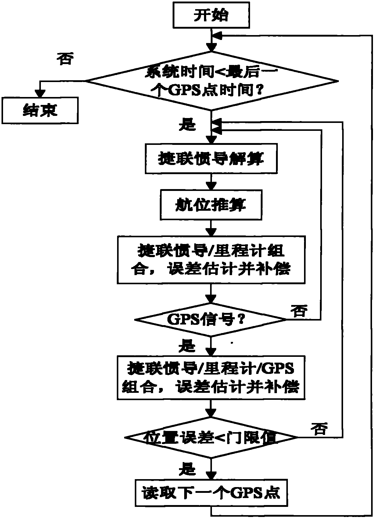
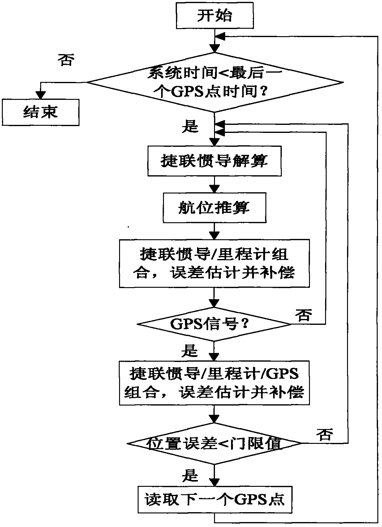
[0030] Specific embodiments of the present invention will be described in detail below in conjunction with the accompanying drawings. In the following description, for purposes of explanation and not limitation, specific details are set forth in order to provide a thorough understanding of the invention. It will be apparent, however, to one skilled in the art that the present invention may be practiced in other embodiments that depart from these specific details.

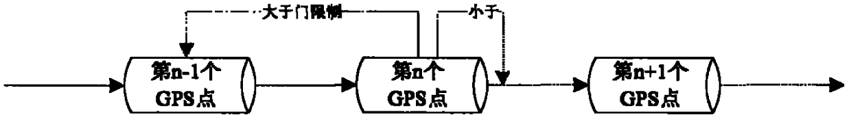
[0031] The basic composition of the inertial pipeline trajectory mapping system is the fiber optic strapdown inertial navigation system, and the auxiliary signals include odometer and fixed distance (1Km ~ 2Km) GPS signal. In the process of pipeline inspection, the inertial pipeline surveying and mapping system is carried on the overall pipeline inspection, and advances at a certain speed by oil pressure or air pressure. Save data in system disk. After the pipeline inspection is completed, the system downloads the...


PUM


Abstract

The invention provides a post-treatment integrated navigation method for surveying and mapping a track of an oil-gas pipeline. The post-treatment integrated navigation method provided by the invention comprises the following steps: carrying out integrated navigation and strap-down inertial navigation/dead reckoning combined navigation on a position without a GPS (Global Position System) modification point through strap-down inertial navigation, dead reckoning and GPS signals at a fixed point; at the GPS modification point, carrying out strap-down inertial navigation/dead reckoning/GPS combined navigation; compensating an error of a strap-down inertial navigation system, an attitude angle error and a scale factor error of a speedometer by using a kalman filter; meanwhile, utilizing a characteristic of processing non-instantaneity by system data, so as to repeatedly estimate and compensate various error items of the system until the system error is less than a set threshold value. Therefore, the system positioning precision is effectively improved, and the actual engineering requirements can be met.

Description

technical field [0001] The invention relates to a post-processing combined navigation method for track surveying and mapping of oil and gas pipelines, in particular to a post-processing method for track surveying and mapping using an inertial measurement device in a special environment for track surveying and mapping of long-distance oil and gas pipelines. Background technique [0002] With the rapid development of my country's national economy, the construction of oil and gas pipelines has entered a peak period. As the most economical and reasonable transportation method for oil and natural gas, pipelines have the advantages of safety, environmental protection, high efficiency and energy saving. Because oil and natural gas are flammable, explosive and toxic, the safe operation of pipelines is very important. After oil and gas pipelines have been in service for a long time, failure accidents will occur due to external interference, corrosion, pipe material and construction q...

Claims


Application Information

Patent Timeline
IPC IPC(8): G01C21/00
Inventor 吕伟唐亚琴张龙刘庆成岳步江郭双红朱强李世扬
Owner 航天科工惯性技术有限公司
Why Eureka
Try Eureka