Land use change modeling method and system implemented in combination with spatial filtering

A technology of spatial filtering and modeling methods, applied in the field of geographic information science, can solve problems such as model accuracy and sensitivity decline, algorithm rule setting cannot be comprehensive, and land category evaluation result deviations, etc., to improve the overall fitting accuracy and eliminate Spatial autocorrelation, full-featured effects

Inactive Publication Date: 2012-08-22
黄波
View PDF3 Cites 14 Cited by
  • Summary
  • Abstract
  • Description
  • Claims
  • Application Information

AI Technical Summary

Problems solved by technology

[0004] The above two types of modeling methods have their own shortcomings and defects: the econometric mathematical model adopts the traditional mathematical model, and lacks in-depth research on the spatio-temporal characteristics of geographic data
Such as the traditional logistic regression method for modeling, the premise is to ensure the unbiasedness and independence of the sample, and because the directly obtained land use change data itself has spatial location information, it is generally affected by the surrounding neighborhood and has Certain spatial autocorrelation characteristics lead to a decline in the over...

Method used


Image

  • Land use change modeling method and system implemented in combination with spatial filtering
  • Land use change modeling method and system implemented in combination with spatial filtering
  • Land use change modeling method and system implemented in combination with spatial filtering

Examples


Embodiment Construction

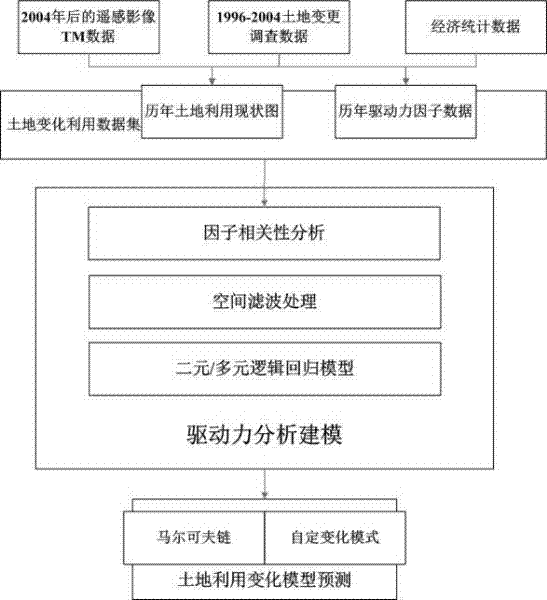
[0018] The specific implementation manners of the present invention will be further described in detail below in conjunction with the accompanying drawings and implementation drawings. The data in the embodiment of the present invention is the modeling process of land use change in Shenzhen City from 1996 to 2008, and this data does not limit the scope of the present invention. This embodiment includes three main components, namely, preprocessing of geographic data and construction of data sets, construction of logistic regression model combined with spatial filtering, and prediction using land use change model.

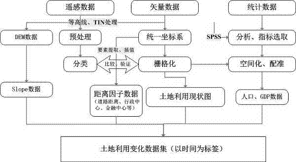
[0019] Step 1: The process of preprocessing geographic data and building datasets is as follows: figure 2 As shown, follow the following requirements:

[0020] First of all, it is necessary to adopt the same land use classification system, the purpose of which is to ensure the convenience of model analysis and the connection between data. For example, the present ...


PUM


Abstract

The invention discloses a land use change modeling method and system implemented in combination with spatial filtering and relates to the field of geographical information sciences. The method focuses on eliminating the spatial autocorrelation influence of data in the process of land use change modeling, and comprises the following steps: collecting original data, and preprocessing the original data so as to generate a data set sequence; determining the optimum distance of spatial filtering by using a variation function, and then splitting variable factors by using a Getis principle based a spatial filtering method; constructing a logistic regression model according to a filtered sample, and assessing the model by using methods such as fitting accuracies and ROC (receiver operating characteristic) curves; and finally, providing a Markov chain and a customized change pattern for forecasting the trend of land use change. According to the invention, based on a statistics mathematical model, a spatial filtering mode is adopted for making up the shortcomings and defects of the mathematical model in geo-spatial calculation, so that through the combination of the two, the fitting accuracy of the model is improved, and the model is more conform to the time and space characteristics of land use change.

Description

technical field [0001] The invention belongs to the technical field of geographic information science, and the specific content is to introduce a spatial filtering algorithm, which is used to eliminate the defect that the land use change spatial data cannot be combined with the traditional statistical model due to the influence of its own spatial autocorrelation, so that after filtering processing The data can be better used in land use change modeling methods and systems. Background technique [0002] At present, land use change modeling methods are roughly divided into two categories according to their research perspectives: the first category is econometric mathematical models with "top-down" characteristics from the perspective of macro-control, such as system dynamics models, Marko Fu chain model and some mathematical statistical models after transformation for geographic space characteristics. The second type is a "bottom-up" artificial intelligence model. Its princip...

Claims


Application Information

Patent Timeline
IPC IPC(8): G06F19/00
Inventor 黄波章欣欣
Owner 黄波
Why Eureka
Try Eureka