Equipment and method for converting space references of land supervision data

A technology of data space and reference conversion, applied in the direction of electrical digital data processing, special data processing applications, instruments, etc., can solve the problem of inaccurate conversion parameters

Inactive Publication Date: 2012-12-19
SOUTHEAST UNIV
View PDF4 Cites 3 Cited by
  • Summary
  • Abstract
  • Description
  • Claims
  • Application Information

AI Technical Summary

Problems solved by technology

The second is that the coordinate systems of various land foundation databases (maps) that have been built before the Second Adjustment include Beijing coordinates in 1954, Xi’an coordinates in 1980, and local coordinate systems. Although the coordinate systems of these land use data are not uniform, they are used as historical land use archive data. It will be used in inspections, audits, and regulatory work. Although the seven-parameter and four-parameter methods currently used can convert between different coordinate systems, due to inaccurate conversion parameters, within a county area of ​​2,000 square kilometers, The error caused by coordinate conversion alone is 2-3m, and the largest can reach more than 10 meters

Method used


Image

  • Equipment and method for converting space references of land supervision data
  • Equipment and method for converting space references of land supervision data

Examples


Embodiment Construction

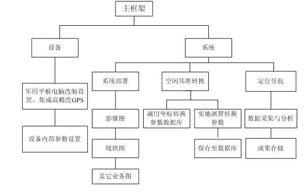
[0020] The present invention will be further described below in conjunction with the accompanying drawings.

[0021] figure 1 For the overall framework schematic diagram of the present invention, the land supervision data spatial reference conversion equipment provided by the present invention includes a global satellite positioning module 1 and a tablet computer 2; the tablet computer 1 is connected with the global satellite positioning module 2; the global satellite positioning module 2, It is used to complete the receiving and processing of the global satellite positioning signal; and transmit the signal data to the tablet computer 2; the tablet computer 1 is used to receive the above signal data, and realize the spatial reference conversion of the global satellite positioning measurement data according to the signal data . Processing and storage of the signal data, using the signal data to establish a spatial database.

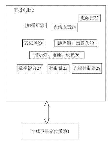
[0022] The tablet computer 1 is connected to the s...


PUM


Abstract

The invention discloses equipment and a method for converting space references of land supervision data. The equipment comprises a global positioning satellite module (1) and a tablet computer (2), wherein the global positioning satellite module (1) is used for receiving and processing global positioning satellite signals and transmits signal data to the tablet computer (2); and the tablet computer (2) is used for receiving the signal data and converting the space references of global positioning satellite measuring data according to the signal data. The method comprises the following steps of 1, configuring global environments of a land supervision data space reference conversion system; and 2, configuring land supervision tasks at this time. The equipment and the method have functions of GPS (global positioning system) positioning and navigating, land supervision data acquisition and data storage, and automatic superposition of field acquired data, field monitoring data and a base map, the precision of data acquired by the equipment meets requirements on land supervision business, the land supervision data with large bytes can be stored, and the equipment is convenient to carry.

Description

technical field [0001] The invention relates to the fields of surveying and mapping, land management and communication signal processing, in particular to a space reference conversion device and system for land supervision data. Background technique [0002] my country's demand for land resources continues to grow strongly, and the number of changes in land use is large, widely distributed, and the cycle of change is short. The state and local governments are still unable to monitor and evaluate land use approval, land supply, land use efficiency, and replenishment of cultivated land in real time. At the same time, the phenomenon of excessive occupation and abuse of land is becoming more and more serious. Illegal use of land continues unabated. There are a large number of cases of use without reporting, use without approval, and use without approval. It is increasingly difficult to supervise illegal land use. [0003] Currently, in the process of reviewing and supervising co...

Claims


Application Information

Patent Timeline
Patent Type & Authority Applications(China)
IPC IPC(8): G06F17/30
Inventor 王庆王志杰
Owner SOUTHEAST UNIV
Why Eureka
Try Eureka