GPS (global position system) terminal-based map matching method for vehicle position tracking

A GPS terminal and map matching technology, applied in the field of map matching, can solve the problems of being too simple and not necessarily matching the road correctly, and achieve the effect of accurate time calculation

Inactive Publication Date: 2013-01-16
CHONGQING UNIV
View PDF3 Cites 40 Cited by
  • Summary
  • Abstract
  • Description
  • Claims
  • Application Information

AI Technical Summary

Problems solved by technology

The method proposed by this method to process the broken line segment of the road is worthy of reference. The curved road is regarded as a series of connected broken line segments, but the road matching and point matc

Method used


Image

  • GPS (global position system) terminal-based map matching method for vehicle position tracking
  • GPS (global position system) terminal-based map matching method for vehicle position tracking
  • GPS (global position system) terminal-based map matching method for vehicle position tracking

Examples


Embodiment Construction

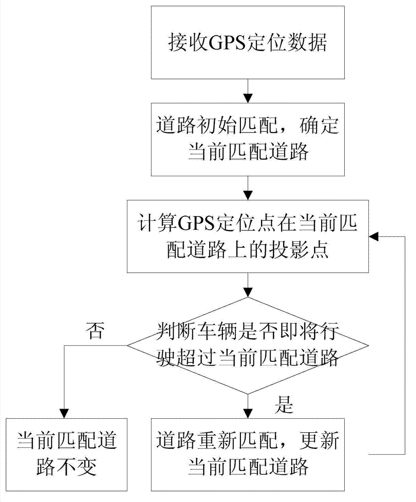
[0069] Embodiments of the present invention are described in detail below, examples of which are shown in the drawings, wherein the same or similar reference numerals designate the same or similar elements or elements having the same or similar functions throughout. The embodiments described below by referring to the figures are exemplary only for explaining the present invention and should not be construed as limiting the present invention.

[0070] Such as figure 1 As shown, the GPS terminal-based map matching method for vehicle position tracking is composed of the following steps: S1. In the field of vehicle navigation, the customer starts the GPS navigation system, receives GPS positioning data and stores the GPS positioning data in the positioning data list From the GPS positioning data, vehicle information such as the GPS positioning point (that is, the longitude and latitude coordinates of the vehicle's location), vehicle speed, and positioning time can be extracted.

...


PUM


Abstract

The invention provides a GPS (global position system) terminal-based map matching method for vehicle position tracking, which belongs to the field of map matching. According to the method, the problem of inaccurate vehicle positioning caused by GPS signal deviation can be solved, a vehicle is matched with the right position on the current running road, the distance between the vehicle and the current road destination node is calculated, when a GPS signal is invalid, the position of the vehicle can be reckoned, and the time that the vehicle reaches the node within the critical zone of the road destination node is calculated. Considering that the GPS terminal for operating a map matching program has limited resources, the method synthetically utilizes a weight-based map matching thought and a curve fitting-based map matching thought which have good real time and combines road-network topology information, and different projection algorithms can be selected according to the current position of the vehicle. By using the method, vehicle position information with accurate real time is provided, and according to the method, vehicle monitoring, real-time traffic information collection, vehicle navigation, etc can be realized.

Description

technical field [0001] The invention relates to a map matching method, in particular to a GPS terminal-based map matching method oriented to vehicle position tracking. Background technique [0002] When GPS is used in the field of intelligent transportation, due to the deviation or invalidity of GPS signals, map matching has become one of the key technologies of vehicle navigation technology. Map matching refers to replacing the track point of the vehicle with the foot point of the GPS point on the map road, or correcting the track point of the vehicle to the foot of the actual road. The road density in today's cities is high, and it is very difficult to match the deviated GPS points to the correct location of the actual road. [0003] The current map matching algorithms mainly include two matching ideas based on geometric information and matching based on network topological relations. The specific algorithms include several matching algorithms based on weight metrics, cur...

Claims


Application Information

Patent Timeline
IPC IPC(8): G01C21/30
Inventor 朱征宇崔明刘琳张东盟
Owner CHONGQING UNIV
Why Eureka
Try Eureka