Fruit-tree positioning map constructing device and method

A map construction and fruit tree technology, which is applied in the construction of fruit tree positioning maps and mobile vehicle-mounted devices, can solve the problems of heavy labor, slow development of large-scale economic forests, and inability to obtain tree crown details, etc., to achieve effective positioning and identification.

Inactive Publication Date: 2013-01-16
BEIJING FORESTRY UNIVERSITY
View PDF3 Cites 24 Cited by
  • Summary
  • Abstract
  • Description
  • Claims
  • Application Information

AI Technical Summary

Problems solved by technology

In the past, fruit farmers used manual methods to obtain such information. This method was labor-intensive, extremely inefficient, and the accuracy of the information was not high. Some fruit farmers even gave up obtaining this information because of this, which led to the slow development of large-scale economic forests in my country.
At present, many scholars and researchers at home and abroad use airborne surveying and

Method used


Image

  • Fruit-tree positioning map constructing device and method
  • Fruit-tree positioning map constructing device and method
  • Fruit-tree positioning map constructing device and method

Examples


Embodiment Construction

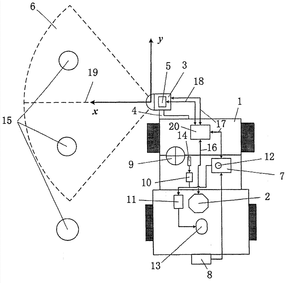
[0019] The construction device of fruit tree positioning map of the present invention, its preferred embodiment is as follows Figure 1 to Figure 4 Shown:

[0020] Such as figure 1 As shown, the components of the device for constructing the fruit tree positioning map of the present invention include: a mobile platform, a GPS positioning module, a laser detection module, a cruise control module, and a main control unit.

[0021] In the present invention, the mobile platform 1 is a wheeled electric agricultural vehicle or a small tractor that can walk between rows of fruit trees. The mobile platform 1 of this embodiment selects a wheeled electric agricultural vehicle, and all components in the present invention are installed on the mobile platform 1. The mobile platform 1 has a maximum load capacity of 450kg, a maximum speed of 25km / h when fully loaded, a maximum gradeability of ≤25%, a rated power of 4.5kw, and four 12V on-board batteries to provide power for the entire fruit ...


PUM


Abstract

The invention belongs to the technical field of automatic measurement and control of agricultural mechanical equipment and relates to a fruit-tree precise positioning mobile vehicle-mounted device for an orchard, in particular to a fruit-tree positioning map constructing method, comprising a mobile platform, a GPS (global position system) positioning module, a laser detection module and a vulgar cruising module. According to the characteristics of the distribution of the fruit trees in the orchard, a wheeled mobile platform which can walk between the rows of fruit trees is adopted, and a laser distance measuring instrument, an inertial measurement device, the GPS positioning module, a radar speed measuring instrument and a measuring and controlling board card are combined together, thus the fruit trees are positioned and identified quickly and effectively in the low-speed cruising state, the information of the distribution of the fruit trees is obtained, the orchard positioning map is constructed in real time, the information of growth and distribution of the fruit trees are obtained accurately, and scientific technological means are provided for the accurate pesticide applying of the fruit trees, the scale operation of the orchard and the precision agriculture digital management.

Description

technical field [0001] The invention belongs to the technical field of automatic measurement and control of agricultural machinery and equipment, and relates to a mobile vehicle-mounted device for precise positioning of fruit trees in an orchard, and in particular to a method for constructing a fruit tree positioning map. Background technique [0002] In order to improve market competitiveness, the business model of my country's economic forest is developing in the direction of scale, systematization and digitization. Under this business model, fruit growers need to obtain accurate growth information of diverse fruit trees, such as actual growth location, trunk size, etc., based on which they can obtain the distribution of fruit trees and formulate reasonable orchard operation plans, such as tree-to-target application of pesticides, etc. In the past, fruit farmers used manual methods to obtain such information. This method was labor-intensive, extremely inefficient, and the ...

Claims


Application Information

Patent Timeline
IPC IPC(8): G09B29/00G01B11/00G01S19/52G01S19/53
CPCY02A40/10
Inventor 康峰郑永军李文彬
Owner BEIJING FORESTRY UNIVERSITY
Why Eureka
Try Eureka