Navigation information acquisition method and intelligent space system with multiple mobile robots

A mobile robot and intelligent space technology, applied in navigation, surveying and mapping, navigation, instruments, etc., can solve problems such as difficult to guarantee real-time performance, difficult to guarantee positioning accuracy, and large amount of information processing, so as to reduce the burden of information processing and improve processing capacity , the effect of enriching navigation information

Inactive Publication Date: 2013-02-06
JIANGSU UNIV OF SCI & TECH
View PDF7 Cites 61 Cited by
  • Summary
  • Abstract
  • Description
  • Claims
  • Application Information

AI Technical Summary

Problems solved by technology

However, there are cumulative errors in optical encoders and drift in inertial navigation, making it difficult to guarantee positioning accuracy
[0006] (3) The laser sensor and infrared sensor carried by the nurse robot cannot penetrate non-transparent obstacles, and can only obtain local environmental information around the robot, but cannot obtain the global information of the robot's motion space, which is not conducive to the robot's global and efficient navigation;
[0007] (4) Although the nurse robot itself carries a CCD vision sensor, which is used for service functions and environmental information acquisition, the acquired information is still local, and the amount of stereo matching calculations is very large. For services with limited hardware resources For robots, the amount of information processing is too large, and real-time performance is difficult to guarantee
The navigation information such as the environmental map required by the robot is still obtained through the sensor system carried by the robot itself, which increases the burden on the service robot and weakens the role of intelligent space
In addition, this space is mainly for single-robot systems. When there are multiple robots in the room, how to efficiently enable the multi-robot system to obtain complete navigation information and how to realize information interaction between multiple robots are not mentioned.

Method used


Image

  • Navigation information acquisition method and intelligent space system with multiple mobile robots
  • Navigation information acquisition method and intelligent space system with multiple mobile robots
  • Navigation information acquisition method and intelligent space system with multiple mobile robots

Examples


Embodiment Construction

[0064] The intelligent space of the multi-mobile robot of the present invention and its navigation information acquisition method are described in detail below in conjunction with the accompanying drawings:

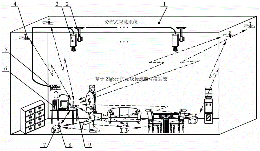
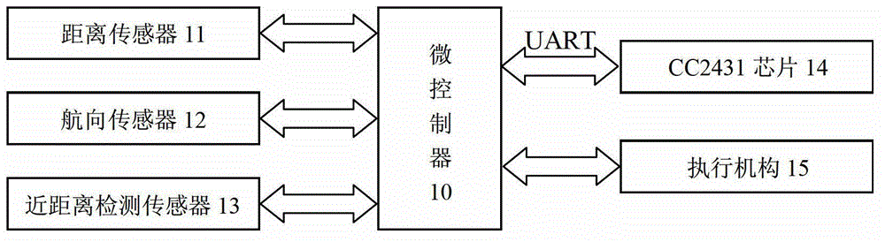
[0065] Such as figure 1 As shown, the smart space includes a distributed vision system and a Zigbee-based wireless sensor network system. The construction of the distributed vision system: the distributed CCD camera 3 is vertically installed on the indoor ceiling 1 through the universal bracket 2, the CCD camera 3 is connected with the multi-channel image acquisition card 5 through the video line, and the image acquisition card 5 is installed on the indoor monitoring host 6 inside the PCI slot. The wireless sensor network system based on Zigbee includes reference node 4 , Zigbee gateway 9 and blind node 8 . The core of reference node 4 is the CC2430 chip with routing function, and it is anchored on the walls around the room. Generally, 3-8 chips are needed. The blind n...


PUM


Abstract

The invention discloses a navigation information acquisition method and an intelligent space system with multiple mobile robots. The intelligent space system comprises a distributed vision system and a Zigbee technology based wireless sensor network system. The method includes: carrying out image stitching based on a maximum gradient similar curve and an affine transformation model, and then carrying out image segmentation based on Otsu threshold segmentation and the mathematical morphology so that an environmental map is obtained. The mobile robots in navigation are positioned mainly by means of visual positioning, and Zigbee and DR (dead reckoning) combined positioning are used for making up visual blind zones in visual positioning supplementarily. The visual positioning refers to that positioning is realized by processing images including robot positions and direction signs mainly based on an HIS color model and the mathematical morphology. Combined positioning refers to that information fusion positioning of Zigbee and DR is achieved by the aid of a federal Kalman filter.

Description

Technical field [0001] The invention relates to an intelligent space construction of multiple mobile robots, in particular to the acquisition of environment maps and positioning information when multiple mobile robots navigate. Background technique [0002] With the development of science and technology and social economy, the field of robot application is changing day by day. Due to the inherent parallelism, the multi-robot system realizes parallel tasks that cannot be completed by a single robot in terms of space, time and function. In order to improve the task execution efficiency of a multi-mobile robot system, it needs to be provided with detailed navigation information. The first is the environmental information of the robot’s motion space, which mainly includes the environmental map of the feasible area and the non-feasible area; the second is the positioning information of the mobile robot, which mainly involves the pose of the mobile robot; the last is the interact...

Claims


Application Information

Patent Timeline
Patent Type & Authority Applications(China)
IPC IPC(8): G01C21/00H04W84/18
Inventor 袁明新申燚王琪刘萍程帅
Owner JIANGSU UNIV OF SCI & TECH
Why Eureka
Try Eureka