Network map rectifying and drawing method under dynamic map projection

A technology of dynamic map and network map, which is applied in the fields of public participation in urban planning, public map network publishing, and integration of different geographic information. It can solve problems such as tile map geometric error, tile geographic information encryption update data, etc., to improve accuracy , improve security, enhance the effect of analysis

Active Publication Date: 2013-04-24
JIANGSU INST OF URBAN PLANNING & DESIGN
View PDF12 Cites 20 Cited by
  • Summary
  • Abstract
  • Description
  • Claims
  • Application Information

AI Technical Summary

Problems solved by technology

[0007] The technical problem to be solved by the present invention is to overcome the deficiencies of the prior art, and propose a tile map registration and drawing method under dynamic map projection to solve the geometric error of the network

Method used


Image

  • Network map rectifying and drawing method under dynamic map projection
  • Network map rectifying and drawing method under dynamic map projection
  • Network map rectifying and drawing method under dynamic map projection

Examples


Embodiment Construction

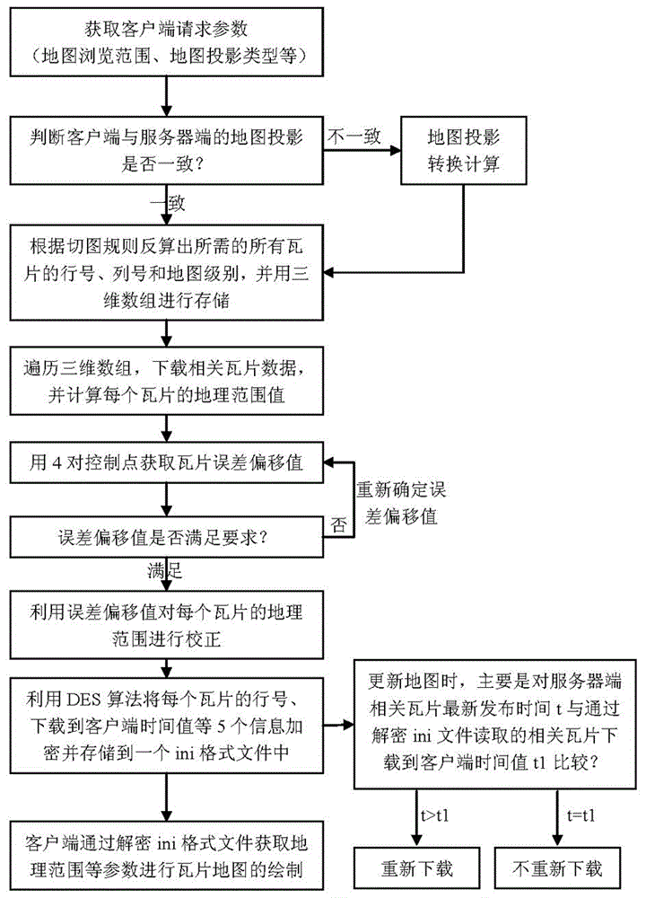
[0028] Below in conjunction with accompanying drawing, technical scheme of the present invention is described in further detail:

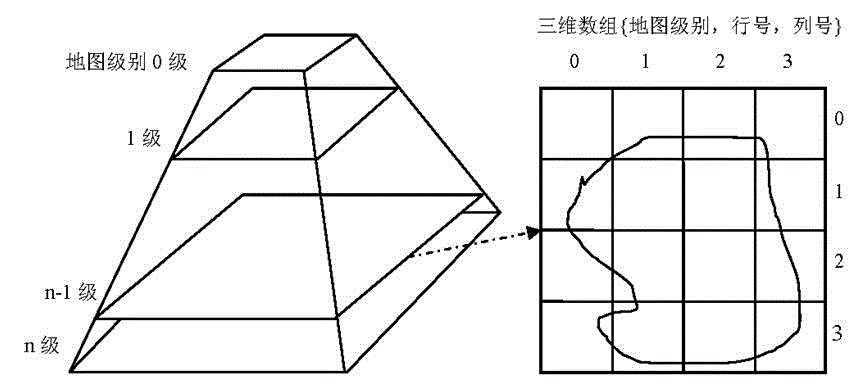
[0029] 1) See attached figure 1 , when the client's C / S end requests tile map browsing and downloading, obtain and record the geographical range value of the map currently browsed by the user and the map projection type used; determine the map projection used by the user and the type of map projection on the server side Whether it is consistent, if not, perform projection conversion calculation, and convert the geographical range value requested by the user into the geographical range value under the server-side map projection; if consistent, do not perform projection conversion calculation on the geographical range requested by the user; for example : The map projection used by the user is Gauss-Klück projection, and the map projection type used by the server is WEB Mercator projection. It is necessary to convert the geographical range value reque...


PUM


Abstract

The invention discloses a network map rectifying and drawing method under dynamic map projection. The method comprises the steps of, first of all, according to the comparison of the projection types of clients sides and server sides, carrying out projection transformation calculation of geographical range values, then calculating reversely to acquire the rank numbers and the map levels of all the tiles to be loaded by using cutting principles of a tile map and requested parameters, and carrying out error correction to the geographical range values of each tile through the error deviation values of the tile map acquired by using a plurality of feature points. When each tile is downloaded, encryption is carried out by using a data encryption standard (DES) encryption algorithm, and the tiles are saved in an ini format file which has a same name with the map tiles in sequence. When the downloading of the needed map is completed, the ini file can be deciphered, the geographical range values and the like after correction are read, and the drawing of each map tile is achieved. The network map rectifying and drawing method under dynamic map projection achieves drawing of the network tiles after the error correction, greatly improves the accuracy of data, and enhances the analyzability of the data.

Description

technical field [0001] The invention relates to the fields of mass map network release, public participation in urban planning, and integration of different geographic information, and in particular to a tile map registration, encrypted drawing, and update method under dynamic map projection. Background technique [0002] With the wide application of web maps in daily life, people put forward higher requirements for the speed, aesthetics and timeliness of web maps. For this, tile maps are a good solution, such as Google online WEB map, China's Tiantu map WEB version. The tile map adopts a multi-resolution hierarchical model. From the bottom layer to the top layer of the tile pyramid, the resolution becomes lower and lower, but the geographical range represented remains the same. [0003] The method of making the tile map is introduced by taking ESRI's ArcGIS software as an example: [0004] First, use ArcGIS software to process the map data, make the required layer scheme,...

Claims


Application Information

Patent Timeline
IPC IPC(8): G09B29/00H04L9/06H04L29/06H04L29/08
Inventor 韦胜
Owner JIANGSU INST OF URBAN PLANNING & DESIGN
Why Eureka
Try Eureka