Satellite gravity inversion method base on gravity gradient error model principle

A technology of satellite gravity inversion and gravity gradient, applied in the direction of electrical digital data processing, special data processing applications, instruments, etc. Strong correlation and other issues, to achieve the effect of low computer performance requirements, fast solution speed, and high inversion accuracy

Inactive Publication Date: 2013-05-08
INST OF GEODESY & GEOPHYSICS CHINESE ACADEMY OF SCI
View PDF7 Cites 9 Cited by
  • Summary
  • Abstract
  • Description
  • Claims
  • Application Information

AI Technical Summary

Problems solved by technology

At the same time, this method does not consider the strong correlation between the vertical gravity gradient and the horizontal gravity gradient, and does not consider the inversion of the cumulative geoid accuracy based on the correlation gravity gradient error, so its inversion accuracy still does not meet the expected requirements

Method used


Image

  • Satellite gravity inversion method base on gravity gradient error model principle
  • Satellite gravity inversion method base on gravity gradient error model principle
  • Satellite gravity inversion method base on gravity gradient error model principle

Examples


Embodiment Construction

[0027] The specific implementation manners of the present invention will be further described below in conjunction with the accompanying drawings.

[0028] The satellite gravity inversion method based on the principle of the gravity gradient error model includes the following steps:

[0029] Step 1: Gravity Gradient Satellite Data Acquisition

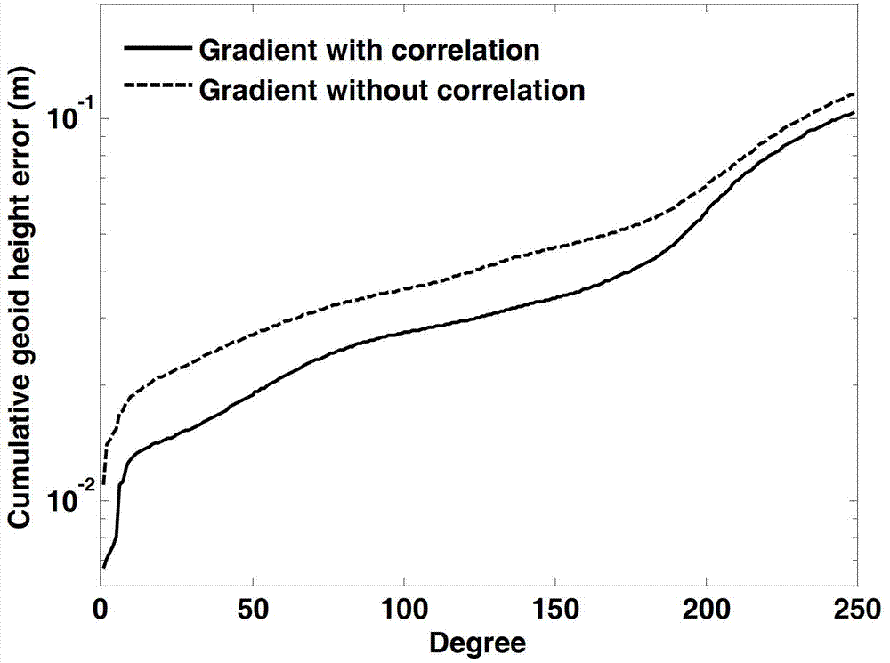
[0030] Collect the satellite gravity gradient error data δT through the gravity gradient instrument onboard the gravity gradient satellite xyz .

[0031] Step 2: Gravity Gradient Error Model Establishment

[0032] In the ground-solid system, the expression of the earth disturbance potential T(r, θ, λ) expanded according to the spherical harmonic function is

[0033] T ( r , θ , λ ) = GM R e Σ l = ...


PUM


Abstract

The invention relates to an earth gravitational field precision measurement method, in particular to a satellite gravity inversion method based on a gravity gradient error model principle. Through analyzing the joint influence of a satellite gravity gradient vertical tensor error, a horizontal tensor error and a correlation tensor error to an accumulated total geoidal surface precision, a novel gravity gradient error model is established, and thus an earth gravitational field is inverted precisely and quickly. The satellite gravity inversion method based on the gravity gradient error model principle is high in inversion precision, quick in earth gravitational field calculating speed, and beneficial for gravity gradient satellite error analysis. The physical meanings of a satellite observation equation is clear, and the requirement to computer performance is low, and thus the satellite gravity inversion method based on the gravity gradient error model principle is an effective method for the inversion of a high precision and high spatial resolution earth gravitational field.

Description

technical field [0001] The present invention relates to satellite gravity gradient science, geodesy, geophysics, aerospace and other cross-technical fields, in particular to a method for analyzing satellite gravity gradient vertical tensor errors, horizontal tensor errors and related tensor errors The joint effect of geoid accuracy establishes a new gravity gradient error model, and then accurately and quickly inverts the method of the earth's gravity field. Background technique [0002] The earth's gravitational field and its time variation reflect the spatial distribution, movement and change of the earth's surface and interior materials, and at the same time determine the fluctuation and change of the geoid. Therefore, determining the fine structure of the Earth's gravitational field and its time-variation is not only a requirement for geodesy, geodynamics, oceanography, glaciology, space science, national defense construction, etc., but also for seeking resources, protec...

Claims


Application Information

Patent Timeline
Patent Type & Authority Applications(China)
IPC IPC(8): G06F19/00
Inventor 不公告发明人
Owner INST OF GEODESY & GEOPHYSICS CHINESE ACADEMY OF SCI
Why Eureka
Try Eureka