Scheduling method and system and equipment of spatial data

A technology for spatial data and scheduling methods, applied in electrical digital data processing, special data processing applications, instruments, etc., can solve the problems of low execution efficiency, difficult commercial use, and long spatial data scheduling time, so as to reduce the occupation of system resources, The effect of reducing scheduling time and protecting normal operation

Active Publication Date: 2013-06-05
CHINA MOBILE COMM GRP CO LTD
View PDF4 Cites 6 Cited by
  • Summary
  • Abstract
  • Description
  • Claims
  • Application Information

AI Technical Summary

Problems solved by technology

[0016] However, since this solution uses a ray tracing algorithm, each ray needs to be traced, and the intersection of spatial data and rays requires a large amount of computation and slow speed, making it difficult to commercialize
[001

Method used


Image

  • Scheduling method and system and equipment of spatial data
  • Scheduling method and system and equipment of spatial data

Examples


Embodiment Construction

[0040] In order to make the object, technical solution and advantages of the present invention more clearly, the present invention will be further described in detail below in conjunction with the accompanying drawings and specific embodiments.

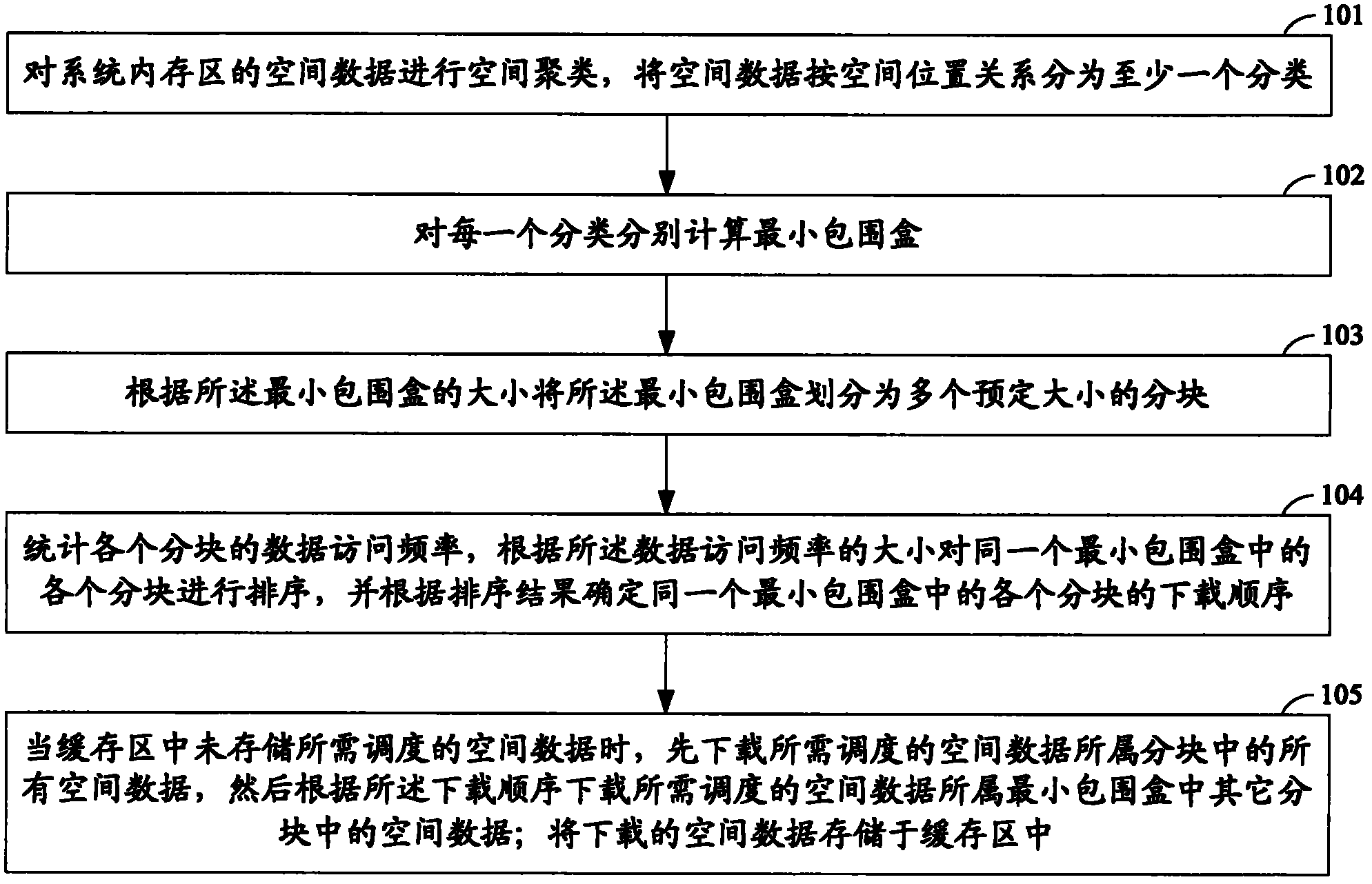
[0041] figure 1 It is a flow chart of the spatial data scheduling method in the present invention.

[0042] like figure 1 As shown, the method includes:

[0043] Step 101, performing spatial clustering on the spatial data in the system memory area, and classifying the spatial data into at least one classification according to the spatial position relationship.

[0044] In this step, spatial clustering is performed on the spatial data in the system memory area, so that the spatial data is classified into at least one classification according to the spatial position relationship.

[0045]Spatial data generally has local characteristics, that is, when a certain spatial data in a certain area is accessed, the possibility of other spati...


PUM


Abstract

The invention provides a scheduling method, a system and equipment of spatial data. The scheduling method comprises the steps that spatial clustering is carried out on the spatial data of a random-access memory, minimum bounding boxes are respectively calculated for each classification, each minimum bounding box is divided into a plurality of blocks of preset sizes, data access frequencies of each block are counted, the blocks in the same minimum bounding box are sorted, download sequence of each block in the same minimum bounding box is confirmed, when a cache region does not store the spatial data needing to be scheduled, all the spatial data in the block to which the spatial data needing to be scheduled belong are downloaded firstly, then the spatial data in the other blocks in each minimum bounding box to which the spatial data needing to be scheduled belong are downloaded according to the download sequence, and then the downloaded spatial data are stored into the cache region. According to the scheduling method, the system and the equipment of the spatial data, range of influence of the cache data can be confirmed efficiently and reasonably, scheduling time of the spatial data is shortened, and efficiency of system execution is improved.

Description

technical field [0001] The invention relates to the technical field of mobile communication data services, in particular to a spatial data scheduling method, system and equipment. Background technique [0002] With the development of aerial photogrammetry and satellite remote sensing technology, 3D browsing of massive terrain image data has become a research hotspot. However, limited by the computer memory and operating system management capabilities, it is obviously not feasible to put all the data into the memory for direct rendering. The required data must be transferred according to the needs of the current 3D scene. Efficient dynamic scheduling of data in the bit space database to the system memory has become the key to ensure the fluency of 3D real-time rendering. [0003] The current spatial data scheduling methods mainly include incremental scheduling method, object relational method, viewpoint tracking method, ray tracing method and other scheduling methods. The a...

Claims


Application Information

Patent Timeline
IPC IPC(8): G06F17/30
Inventor 邢辉峰温亮生贺赢阎啸天
Owner CHINA MOBILE COMM GRP CO LTD
Why Eureka
Try Eureka