Visual-sense-based aircraft position and attitude determination method under mark-free environment

A determination method and aircraft technology, applied in the field of computer vision, can solve problems such as inapplicability and lack of geographic information, and achieve the effect of improving accuracy

Active Publication Date: 2013-06-26
TSINGHUA UNIV
View PDF8 Cites 29 Cited by
  • Summary
  • Abstract
  • Description
  • Claims
  • Application Information

AI Technical Summary

Problems solved by technology

[0003] Although the above methods can effectively solve the problem of determining the position and attitude of UAVs and other aircraft when they lose communication and external positioning signals, they all need to have enough information about the flight area, such as reference maps, artificial identification and other information, so Not suitable for flight environments lacking geographic information, such as flying in hostile regions, unfamiliar regions, and changing environments

Method used


Image

  • Visual-sense-based aircraft position and attitude determination method under mark-free environment
  • Visual-sense-based aircraft position and attitude determination method under mark-free environment

Examples


Embodiment Construction

[0018] Embodiments of the present invention are described in detail below, examples of which are shown in the drawings, wherein the same or similar reference numerals designate the same or similar elements or elements having the same or similar functions throughout. The embodiments described below by referring to the figures are exemplary only for explaining the present invention and should not be construed as limiting the present invention.

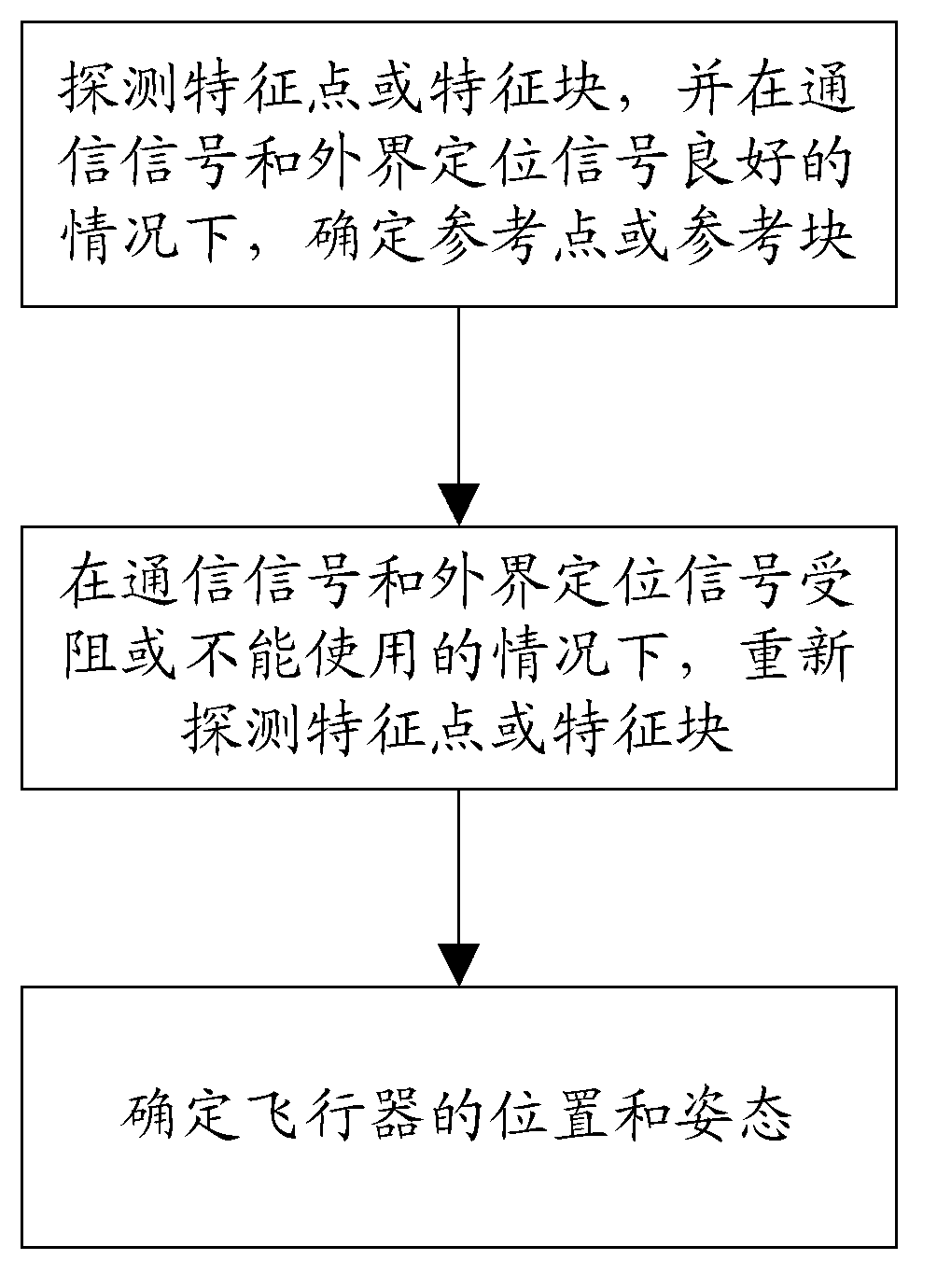
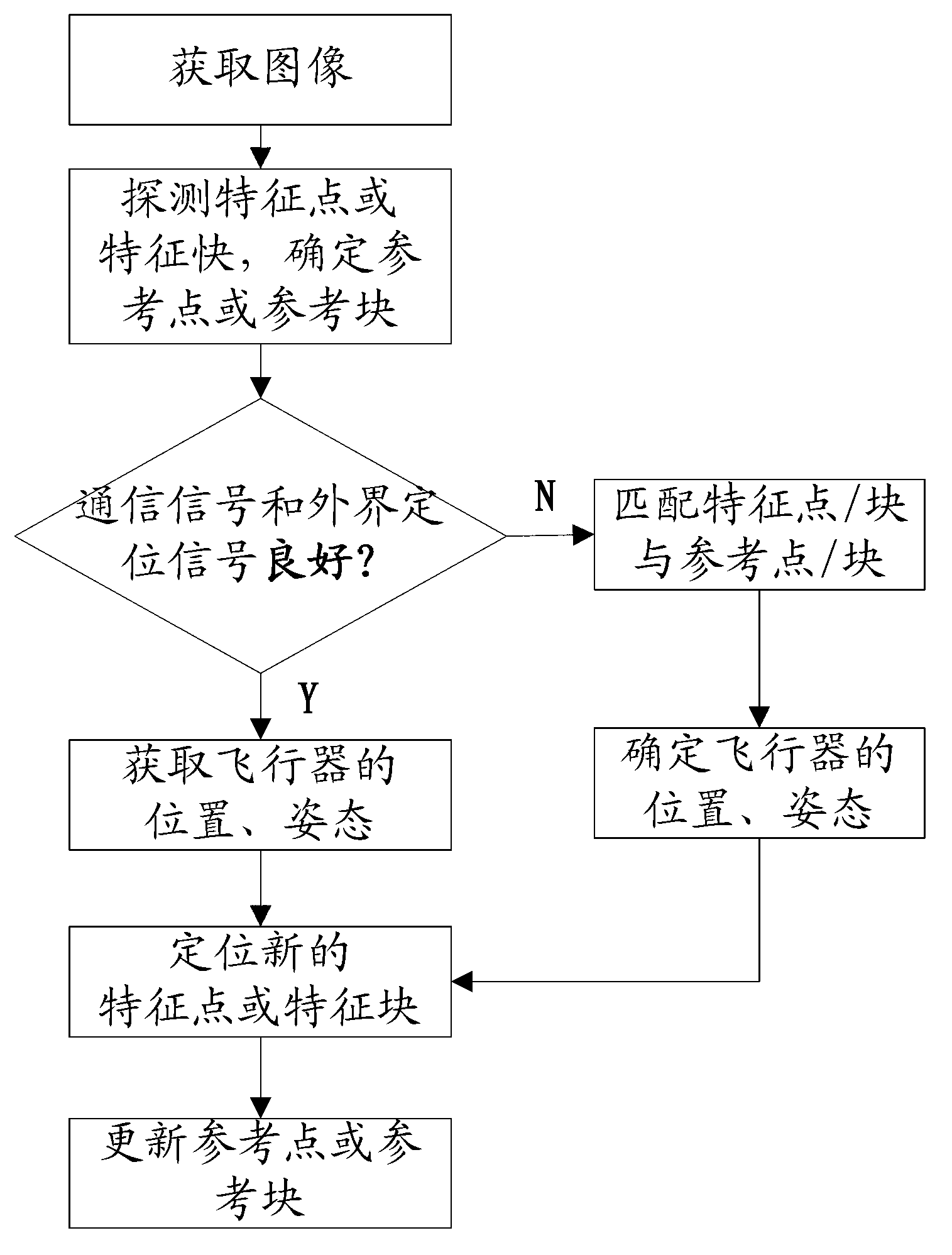
[0019] figure 1 It is a flow chart of the method for determining the position and attitude of an aircraft based on vision in an unmarked environment of the present invention. As can be seen from the figure, the method for determining the position and attitude of an aircraft based on vision in an unmarked environment includes the following steps:

[0020] S1: Detect feature points or feature blocks, and determine reference points or reference blocks when the communication signal and external positioning signal are good;

[0021] S2: When...


PUM


Abstract

The invention discloses a visual-sense-based aircraft position and attitude determination method under a mark-free environment. The method comprises the following steps of: detecting characteristic points or characteristic blocks, and confirming the characteristic points or the characteristic blocks under the condition that a communication signal and an external positioning signal are good; detecting the characteristic points or the characteristic blocks again under the condition that the communication signal and the external positioning signal are blocked or can not be used; and matching the characteristic points or the characteristic blocks detected in the step above with the characteristic points or the characteristic blocks to confirm the position and the attitude of an aircraft. According to the method, under the condition that the communication and positioning signals are blocked, and geographic information of a fly region lacks, the position and the attitude of the aircraft can be exactly determined by an imaging system carried by the aircraft, and the guarantee can be provided for the safe fly of the aircraft. Furthermore, the precision can be further improved by using the method in combination with a sensor such as a gyro, a distance measurement machine and an inertia measurement unit, and the autonomous navigation of the aircraft can be carried out in combination with the method.

Description

technical field [0001] The invention relates to the technical field of computer vision, in particular to a method for determining the position and attitude of an aircraft based on vision in an unmarked environment. Background technique [0002] At present, there are two methods for typical flight control of UAVs: one is to carry out manual control on the remote ground or air command platform through the communication link to realize automatic flight, and the other is to plan the route by the ground station for automatic flight. Both methods often require positioning satellites to provide position information. However, under certain conditions, communication signals, satellite positioning signals will be blocked or missing, such as intentional interference, flying near the ground or in canyons, covered by buildings or indoors, these situations will cause drones to Lose or temporarily lose control. At this time, certain measures need to be taken to ensure the safe flight of ...

Claims


Application Information

Patent Timeline
Patent Type & Authority Applications(China)
IPC IPC(8): G01C21/00
Inventor 戴琼海刘宇驰
Owner TSINGHUA UNIV
Why Eureka
Try Eureka