Method for quickly obtaining and measuring orthophotoquad of city skyline contour line facede

An orthophoto map and measurement method technology, applied in the field of image processing, can solve the problems of urban skyline height, length measurement error, lack of accurate and effective image information and measurement data, urban skyline image perspective deformation, etc. Achieve the effect of saving working time, convenient interaction and eliminating image errors

Active Publication Date: 2013-07-10
ARCHITECTURAL DESIGN & RES INST OF SOUTHEAST UNIV CO LTD
View PDF3 Cites 12 Cited by
  • Summary
  • Abstract
  • Description
  • Claims
  • Application Information

AI Technical Summary

Problems solved by technology

However, the distribution of urban building groups that make up the city skyline is often in the shape of a curve, and the actual length is often more than several kilometers, or even more than 5 kilometers. When the method of fixed-point single-frame shooting is adopted, it also appears on the image. The actual distance between the subject and the shooting point is often very different, resulting in a large perspective distortion in the fixed-point single-shot image of the city skyline. When the same method is used for calculation, the buildings at both ends of the image will be larger than the center of the image The scale of the buildings in the city is relatively small, resulting in calculation errors in the height and length of the city skyline. Although the calculation errors caused by perspective can be corrected by camera equipment, they still cannot be completely eliminated.
This makes urban planning and construction departments lack accurate and effective image information and measurement data in the construction of urban skylines and space guidance

Method used


Image

  • Method for quickly obtaining and measuring orthophotoquad of city skyline contour line facede
  • Method for quickly obtaining and measuring orthophotoquad of city skyline contour line facede
  • Method for quickly obtaining and measuring orthophotoquad of city skyline contour line facede

Examples


Embodiment Construction

[0037] Below in conjunction with accompanying drawing and specific embodiment, further illustrate the present invention, should be understood that these embodiments are only for illustrating the present invention and are not intended to limit the scope of the present invention, after having read the present invention, those skilled in the art will understand various aspects of the present invention Modifications in equivalent forms all fall within the scope defined by the appended claims of this application.

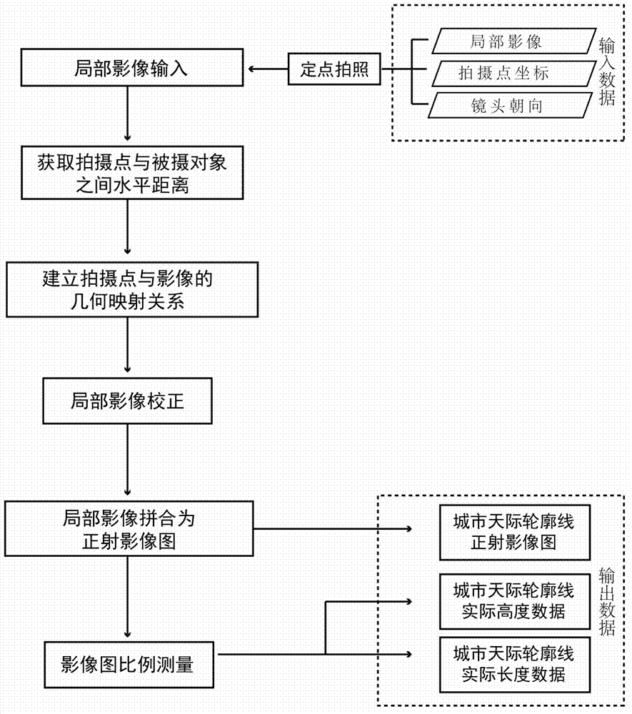
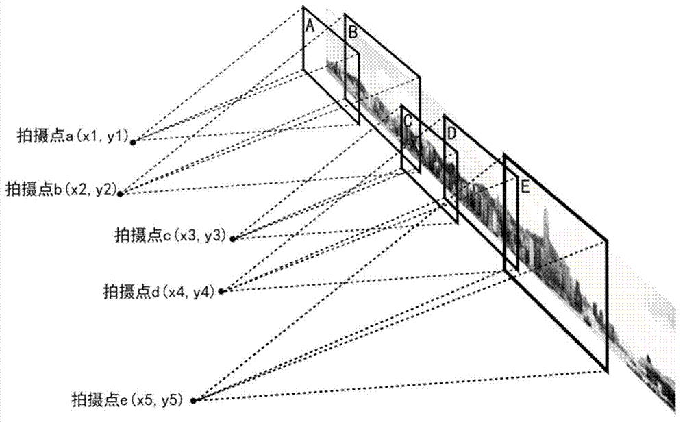
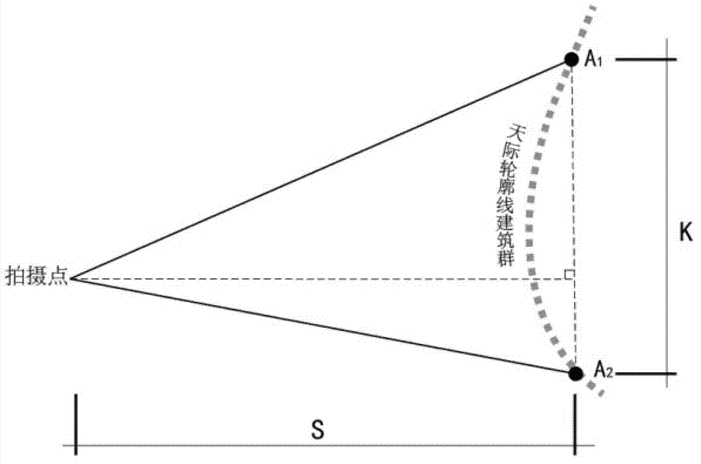
[0038] The present invention aims at the image distortion and data measurement error caused by the perspective of the traditional city skyline elevation image map acquisition method, and proposes a method for fast acquisition and measurement of the city skyline elevation orthophoto image map, which consists of the following steps Composition: First, use a camera with a coordinate acquisition device to take partial images of the city skyline facade segment by segment and r...


PUM


Abstract

The invention discloses a method for quickly obtaining and measuring an orthophotoquad of a city skyline contour line facede. The method comprises the following steps of: shooting a local image of the city skyline contour line facede hop by hop by a camera with a coordinate obtaining device, and recording the coordinate direction and the lens orientation of the camera at each shooting time; obtaining the horizontal distance between each shooting point and an object to be shot; building a geometric mapping relationship between each shooting point and the object to be shot to generate the orthophotoquad of the city skyline contour line facede; and outputting measurement data of the orthophotoquad of the city skyline contour line facede in combination with the city skyline contour line facede and the orthophotoquad of the city skyline contour line facede. After the method is used, the image distortion error caused by the conventional technology can be reduced, and the measurement precision can be improved.

Description

technical field [0001] The invention relates to the field of image processing, in particular to a method for quickly acquiring and measuring an orthophoto map of a city skyline and facade. Background technique [0002] The city skyline, also known as the city skyline, is the overall image composed of high-rise buildings in the city, or a partial image composed of high-rise buildings. The urban skyline directly depends on the development and layout of urban land construction, and it is an intuitive reflection of the results of urban planning and construction. Therefore, the urban skyline is an important content of urban planning and construction departments for urban construction and adjustment. [0003] Obtaining the elevation orthophoto map of the current city skyline is the primary and important technical link for the urban planning and construction department to carry out skyline construction and spatial adjustment. However, the distribution of urban buildings that make ...

Claims


Application Information

Patent Timeline
Patent Type & Authority Applications(China)
IPC IPC(8): G01C11/00
Inventor 杨俊宴史宜
Owner ARCHITECTURAL DESIGN & RES INST OF SOUTHEAST UNIV CO LTD
Why Eureka
Try Eureka