Line recommendation system and method based on Beidou satellite/GPS (global positioning system) data

A GPS data and recommendation system technology, applied in the field of navigation, can solve the problems of reducing the utilization rate of freight vehicles and the empty rate, the selection of freight recommended routes, and not considering real-time road condition information, so as to save energy consumption of transportation resources and reduce urban pollution. Index, the effect of solving real-time problems

Active Publication Date: 2013-09-04
深圳市北斗智能科技有限公司
View PDF1 Cites 37 Cited by
  • Summary
  • Abstract
  • Description
  • Claims
  • Application Information

AI Technical Summary

Problems solved by technology

[0005] The present invention provides a route recommendation system and method based on Beidou / GPS data, aiming to solve the problem that the existing freight route recommendation method does not consider real-time road condition information to reduce the utilization rate and empty load rate of freight vehicles, and the freight recommended route only has A technical problem that cannot be selected according to actual needs

Method used


Image

  • Line recommendation system and method based on Beidou satellite/GPS (global positioning system) data
  • Line recommendation system and method based on Beidou satellite/GPS (global positioning system) data
  • Line recommendation system and method based on Beidou satellite/GPS (global positioning system) data

Examples


Embodiment Construction

[0024] In order to make the object, technical solution and advantages of the present invention clearer, the present invention will be further described in detail below in conjunction with the accompanying drawings and embodiments. It should be understood that the specific embodiments described here are only used to explain the present invention, not to limit the present invention.

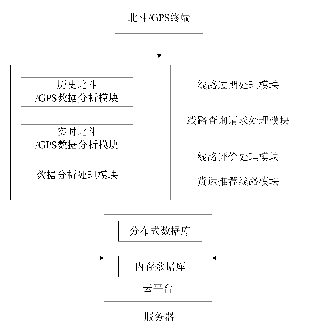
[0025] see figure 1, is a schematic structural diagram of a route recommendation system based on Beidou / GPS data according to an embodiment of the present invention. The route recommendation system based on Beidou / GPS data in the embodiment of the present invention includes a Beidou / GPS terminal and a server. The Beidou / GPS terminal is used to locate and send vehicle Beidou / GPS information in real time. Characteristic information such as the time when the information was sent, the current latitude and longitude, and / or the current mileage. In the embodiment of the present invention, the unique id...


PUM


Abstract

The invention relates to a line recommendation system and method based on Beidou satellite/GPS (global positioning system) data. The line recommendation system based on Beidou satellite /GPS (global positioning system) data comprises a Beidou/GPS terminal and a server, wherein the Beidou/GPS terminal is used for positioning and sending the Beidou/GPS information of a vehicle; the server is used for receiving the Beidou/GPS information of the vehicle; according to the unique identification of the vehicle, the track data of each vehicle is grouped; according to a truncation rule, the track data record of each vehicle is truncated to generate a plurality of paths; and after the paths are subjected to clustering analysis, a recommendation line is output according to different attributes. When the invention is implemented, the problem of insufficient instantaneity of the freight recommendation line can be solved, a proper freight line can be conveniently selected for a driver according to the practical situation, and the logistics industry efficiency and the use ratio of a freight vehicle can be improved.

Description

technical field [0001] The invention belongs to the technical field of navigation, and in particular relates to a route recommendation system and method based on Beidou / GPS data. Background technique [0002] In recent years, with the widespread use of civilian Beidou / GPS equipment in the logistics industry and the popularity of location-based services, a large number of Beidou / GPS equipment sends the current location to the management center at a certain frequency. The large-scale data generated pose great challenges for complex real-time retrieval and monitoring. According to relevant data, the total amount of social logistics in China reached 158 trillion yuan in 2012, and the total cost of logistics accounted for about 18.4% of GDP. , is still more than double the total amount of social logistics, which also means that China's overall logistics cost is still at a high level, and the logistics industry has huge room for development. In this context, the logistics route ...

Claims


Application Information

Patent Timeline
Patent Type & Authority Applications(China)
IPC IPC(8): G01S19/39
Inventor 张帆甘波白雪赵娟娟李晔邹瑜斌须成忠
Owner 深圳市北斗智能科技有限公司
Why Eureka
Try Eureka