Sea fog all-time all-weather inversion method based on multispectral weather satellite information

A meteorological satellite and multi-spectral technology, which is used in the analysis of suspensions and porous materials, measurement devices, instruments, etc., can solve the problems of difficult application, sparse distribution of actual measurement stations on the sea surface, and inability to monitor sea fog, etc., so as to improve the inversion accuracy. Effect

Inactive Publication Date: 2013-09-11
NANJING UNIV
View PDF2 Cites 32 Cited by
  • Summary
  • Abstract
  • Description
  • Claims
  • Application Information

AI Technical Summary

Problems solved by technology

However, compared with the land, the distribution of actual measurement sites on the sea surface is scarce, which is far from meeting the needs of monitoring sea fog, so the application of this method in the sea is still a problem

Method used


Image

  • Sea fog all-time all-weather inversion method based on multispectral weather satellite information
  • Sea fog all-time all-weather inversion method based on multispectral weather satellite information
  • Sea fog all-time all-weather inversion method based on multispectral weather satellite information

Examples


Embodiment Construction

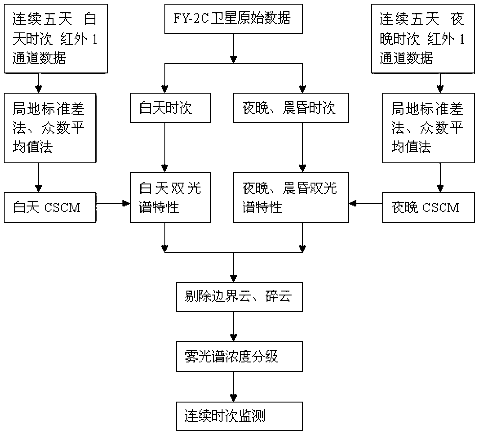
[0030] The technical solutions of the present invention will be described in detail below in conjunction with the accompanying drawings.

[0031] Overview of FY-2C Meteorological Satellite Features

[0032] FY2C is my country's first operational meteorological satellite in geostationary orbit. It was launched by the Long March 3A carrier rocket at 9:20 on October 19, 2004, and is positioned over the equator at 105° east longitude. Table 1 shows the parameters of all five channels of FY2C visible light channel, water vapor channel, split window infrared channel and mid-infrared channel. It is worth mentioning that FY2C has added a mid-infrared band (3.5μm-4.0μm), which can be applied to the observation of forest fires, grassland fires, sea fog, land fog, sandstorms, etc.

[0033] Table 1 FY-2C visible light and infrared spin scanning radiometer characteristics

[0034]

[0035] FY2C has two observation modes: "Flood Season Observation" and "Non-Flood Season Observation". ...


PUM


Abstract

The invention discloses a sea fog all-time all-weather inversion method based on multispectral weather satellite information. According to the method, the influence of the diurnal change of sea surface temperature on the fog region identification is considered, a sea surface brightness temperature ambient field (clear sky composite map) (CSCM) is established aiming at the daytime and night respectively and independently according to the diurnal variation characteristic of the sea surface temperature, and a foundation is laid for accurate inversion of dissipation and concentration change in a satellite monitoring sea surface fog region; furthermore, the method aims at typical spectral characteristics of sea fog satellite monitoring at three different time intervals of daytime, night and morning and night, the optimized spectral combination and corresponding algorithm flow are respectively selected, and the all-time accurate identification of a sea surface fog region, a clear sky region and a cloud region is reliably realized.

Description

technical field [0001] The invention relates to an all-weather and all-weather inversion method for sea fog based on multispectral meteorological satellite information, belonging to the field of sea fog research. Background technique [0002] Sea fog, especially the sea fog with a wide range, high concentration and long duration, has had a huge impact on ship navigation, fishery production, the environment of coastal cities, and even the military. In areas where sea fog occurs, the visibility on the sea surface is low, which has caused serious safety hazards to port operations and ships sailing. According to the incomplete statistics of Qingdao Maritime Safety Administration, about 50% of the ship collision or grounding accidents at sea from 2000 to 2003 were related to sea fog. When sea fog matures, it usually extends to land, which also poses a threat to coastal transportation and socio-economic activities. The difference between sea fog and land fog is that some of the ...

Claims


Application Information

Patent Timeline
Patent Type & Authority Applications(China)
IPC IPC(8): G01N15/06G01W1/00
Inventor 郁凡朱庆陆菁
Owner NANJING UNIV
Why Eureka
Try Eureka