
Ultrahigh-resolution spaceborne SAR imaging processing method and device

An ultra-high-resolution, imaging processing technology, applied in measurement devices, radio wave reflection/re-radiation, utilization of re-radiation, etc. Problems such as limited model accuracy

Active Publication Date: 2013-09-25
INST OF ELECTRONICS CHINESE ACAD OF SCI
View PDF4 Cites 13 Cited by
  • Summary
  • Abstract
  • Description
  • Claims
  • Application Information

AI Technical Summary

Problems solved by technology

The traditional spaceborne SAR equivalent slant range model uses a straight line trajectory to simulate the orbit, while the orbital curvature of the spaceborne platform is only described by the second-order spaceborne SAR Doppler parameter, which leads to the traditional spaceborne SAR slant range The accuracy of the model is limited, and it cannot meet the requirements of the oblique range model for spaceborne SAR imaging processing at ultra-high resolution, which restricts the development of high-resolution spaceborne SAR technology
[0004] High-precision imaging processing methods are the basis for obtaining high-quality radar images. Most of the current imaging processing methods, such as the range-Doppler algorithm, frequency modulation scaling algorithm, and wavenumber domain algorithm, are based on the traditional equivalent slope range model, and most of them do not consider Or only partially consider the imaging processing of the spaceborne SAR curved orbit, so that the data cannot be well focused, and the image quality will drop sharply, thus failing to meet the requirements of high-resolution applications

Method used


Image

  • Ultrahigh-resolution spaceborne SAR imaging processing method and device
  • Ultrahigh-resolution spaceborne SAR imaging processing method and device
  • Ultrahigh-resolution spaceborne SAR imaging processing method and device

Examples


Embodiment Construction

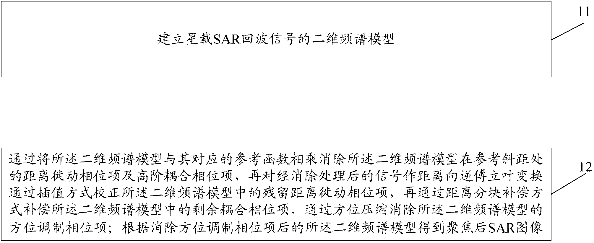
[0088] The present invention describes a super-high resolution space-borne SAR imaging processing method, such as figure 1 As shown, the method includes:

[0089] Step 11: Establish a two-dimensional spectrum model of the spaceborne SAR echo signal;

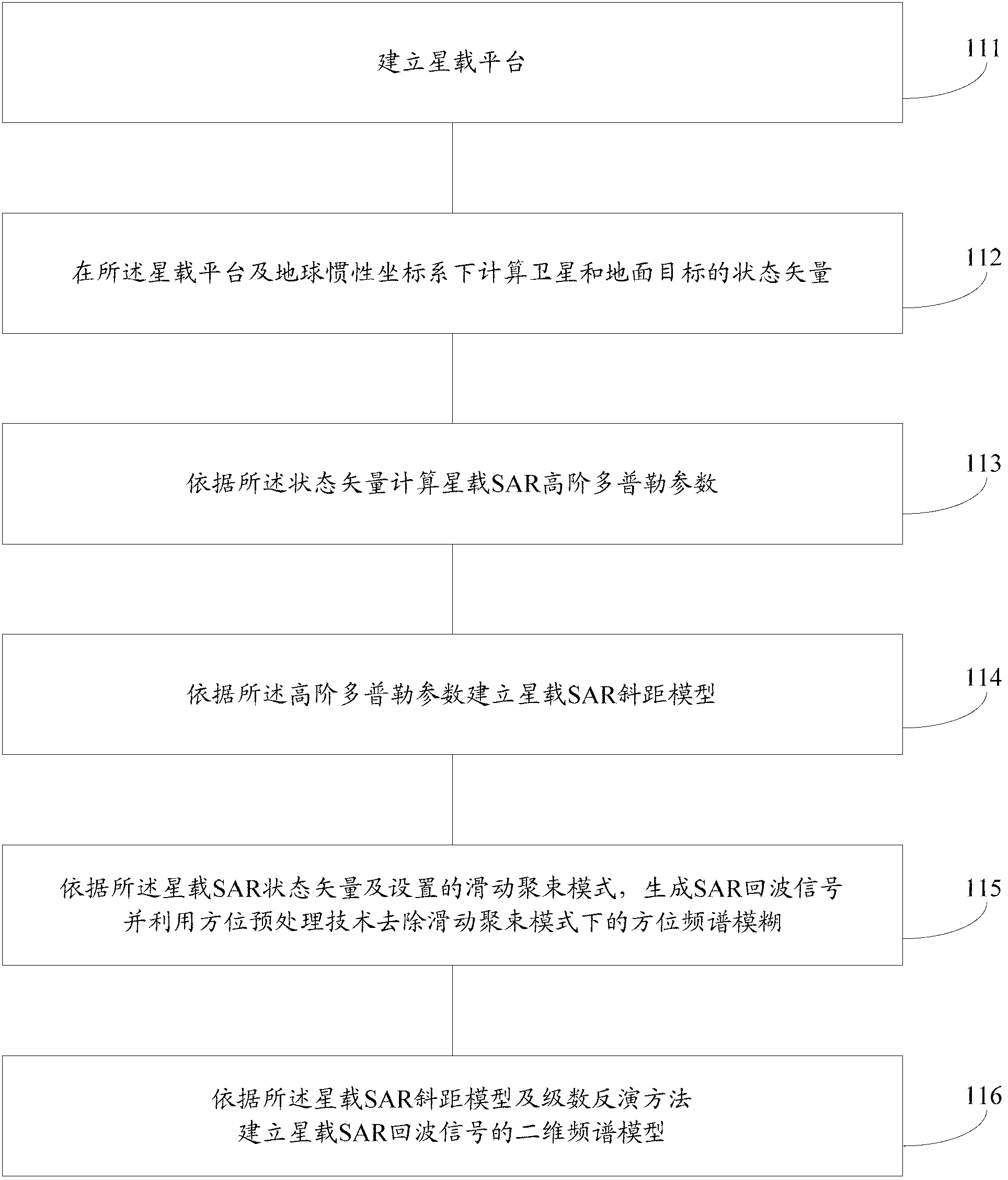
[0090] Here, the step 11 is completed by a computer, figure 2 It is a schematic diagram of a specific embodiment of step 11, such as figure 2 As shown, the step 11 includes:

[0091] Step 111: Establishing an on-board platform;

[0092] Specifically, establish the orbital data of the spaceborne platform and the ground imaging scene;

[0093] Step 112: Calculate the state vectors of satellites and ground targets under the spaceborne platform and the earth's inertial coordinate system; the state vectors include: the distance vector r of the satellite s , velocity vector v s , acceleration vector A s , the first-order acceleration vector A s ′ and the second-order acceleration vector A s "; the distance vector r of the gr...


PUM


Abstract

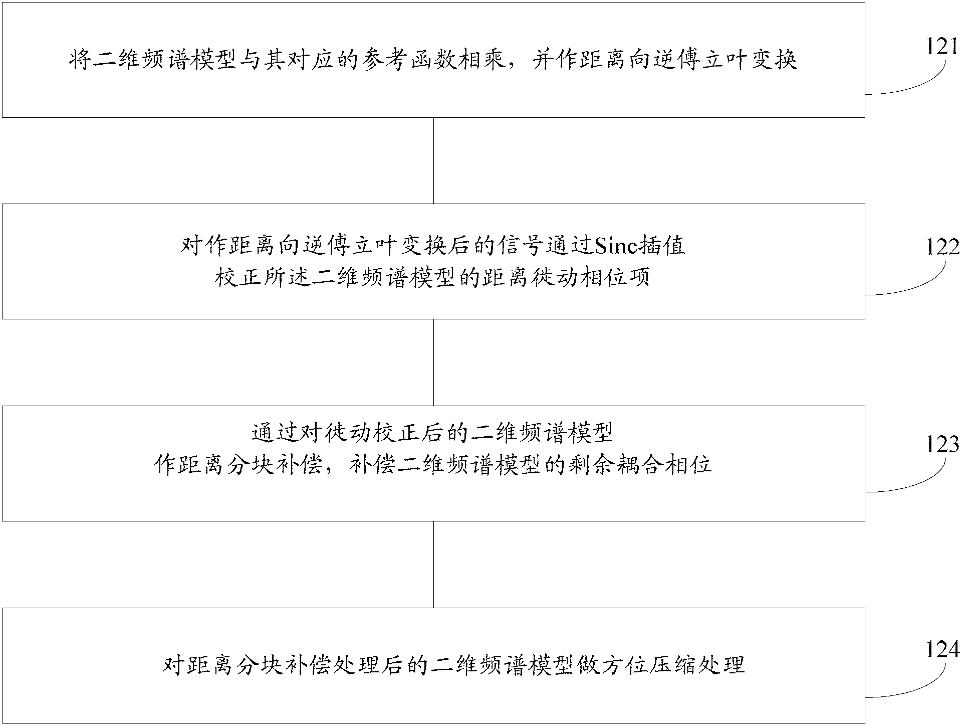
The invention discloses an ultrahigh-resolution spaceborne SAR imaging processing method. The ultrahigh-resolution spaceborne SAR imaging processing method comprises the following steps of establishing a two-dimension frequency spectrum model of a spaceborne SAR echo signal, eliminating a range-migration phase item and a high-order coupling phase item which are arranged at the position of the reference slope distance of the two-dimension frequency spectrum model through multiplying the two-dimension frequency spectrum model by a reference function which corresponds to the two-dimension frequency spectrum model, conducting distance-direction reverse Fourier transform on the processed signal with the range migration phase item and the high-order coupling phase item are eliminated, correcting the residual distance migration quantity of the two-dimension frequency spectrum model in an interpolation mode, compensating the rest of high-order coupling phase items of the two-dimension frequency spectrum model in a distance blocking compensation mode, eliminating an orientation modulation phase item of the two-dimension frequency spectrum model in an orientation compression mode, and finally obtaining a spaceborne SAR image after focusing. In addition, the invention further discloses an ultrahigh-resolution spaceborne SAR imaging processing device. Through the ultrahigh-resolution spaceborne SAR imaging processing method and device, the high-quality ultrahigh-resolution spaceborne SAR image can be obtained. The high-quality ultrahigh-resolution spaceborne SAR image has a good locating capability and meets the application demand under the condition of high resolution.

Description

technical field [0001] The invention relates to an ultra-high resolution spaceborne synthetic aperture radar (SAR, Synthetic Aperture Radar) imaging processing technology, in particular to an ultrahigh resolution spaceborne SAR imaging processing method and device. Background technique [0002] Spaceborne SAR comprehensively utilizes synthetic aperture technology, pulse compression and data processing technologies, and can obtain higher image resolution with a shorter antenna. It is a high-resolution microwave side-view imaging with all-weather and all-time characteristics. radar. [0003] Based on the rapid development and wide application of spaceborne SAR technology, high-resolution low-orbit spaceborne SAR has put forward more stringent requirements for imaging processing methods. The traditional spaceborne SAR equivalent slant range model uses a straight line trajectory to simulate the orbit, while the orbital curvature of the spaceborne platform is only described by t...

Claims


Application Information

Patent Timeline
Patent Type & Authority Applications(China)
IPC IPC(8): G01S7/41G01S13/90
Inventor 罗运华赵秉吉韩晓磊王宇
Owner INST OF ELECTRONICS CHINESE ACAD OF SCI
Learn More