Method and system for automatically tracking medium earth orbit navigational satellite through servo antenna

An automatic tracking and navigation satellite technology, which is applied in satellite radio beacon positioning system, radio wave measurement system, measurement device, etc., can solve the problem of unsuitable navigation satellite tracking, inability to directly use memory tracking, and lagging dynamic response speed of step tracking And other issues

Active Publication Date: 2013-10-23
SHANGHAI JIAO TONG UNIV
View PDF4 Cites 29 Cited by
  • Summary
  • Abstract
  • Description
  • Claims
  • Application Information

AI Technical Summary

Problems solved by technology

[0004] However, there are obvious defects in the above three modes: manual tracking requires manual participation, cumbersome operation, and not flexible enough; the premise that memory tracking is feasible is that the system saves the past historical information of the target satellite to be tracked, and the major global satellite navigation systems As far as GPS satellites are concerned, the operating cycle of only GPS satellites is half a sidereal day, which is suitable for memory tracking strategies. Geostationary orbit satellites (GEO) of the Beidou system (BDS) cannot use this method due to large jitter drift. Non-geostationary orbit satellites are the same every day. The observation angles are not the same at all times, and memory tracking cannot be used directly; the dynamic response speed of step tracking is seriously lagging behind, and it is quite passive if it is required to switch the target satellite
[0005] After searching the existing technical documents, it is found that the patent application number 200580011176.6 is named: satellite tracking antenna system and the method used, which adopts the step-tracking method, and there is a certain delay in actual use; the patent application number 201010152646.3 is named: Although the satellite communication self-tracking control system for offshore platforms supports mobile measurement and control platforms, it needs to add beacon receivers, which puts higher requirements on system equipment, and is not suitable for tracking navigation satellites that do not emit beacons.

Method used


Image

  • Method and system for automatically tracking medium earth orbit navigational satellite through servo antenna
  • Method and system for automatically tracking medium earth orbit navigational satellite through servo antenna
  • Method and system for automatically tracking medium earth orbit navigational satellite through servo antenna

Examples


Embodiment 1

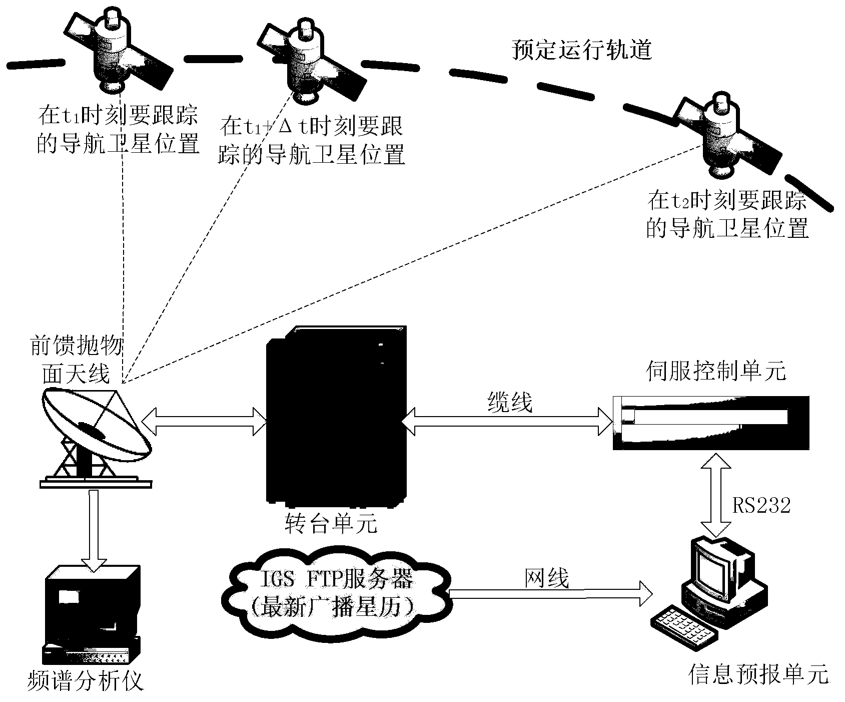
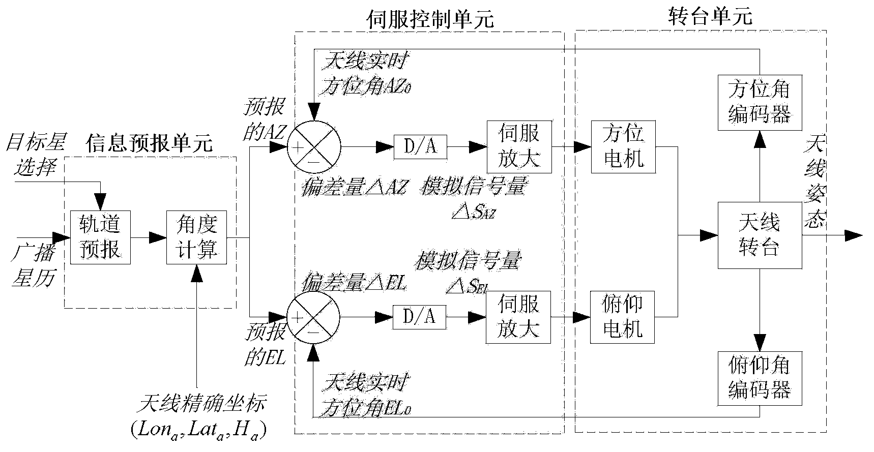
[0038] The application environment of this embodiment includes: an information forecasting unit for orbit forecasting and angle calculation operations, a servo control unit for adjusting the attitude of the antenna in a closed-loop feedback mode, and a turntable for driving the antenna turntable to rotate in the two axes of azimuth and pitch unit, a feed-forward large-aperture parabolic antenna for receiving target satellite signals, and a spectrum analyzer for observing the quality of received signals, wherein: the information prediction unit communicates with the servo control unit through the RS232 serial port.

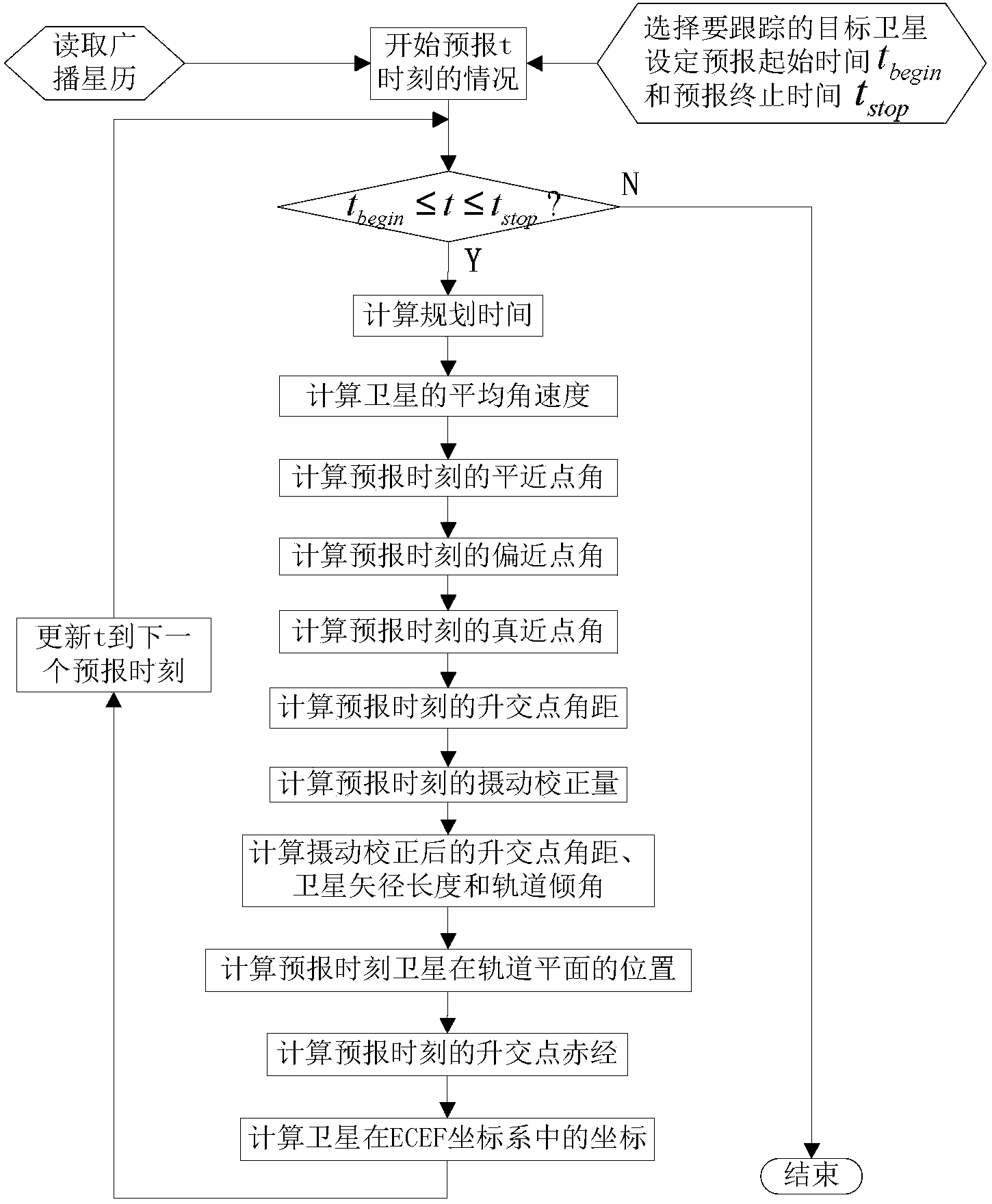
[0039] The present embodiment takes the tracking of GPS satellite PRN-19 as an example, and the specific implementation steps are as follows:

[0040] Step 1: Select GPS from the global satellite navigation system (GPS / Galileo / BDS) in the display and control interface, and the information forecast unit reads the corresponding broadcast ephemeris. The parameters incl...


PUM


Abstract

The invention relates to a method and system for automatically tracking a medium earth orbit navigational satellite through a servo antenna, and belongs to the technical field of satellite navigation signal quality monitoring. The system comprises an information prediction unit, a servo control unit, a rotary table unit, the feed-forward large-diameter parabolic antenna and a spectrum analyzer. The information prediction unit is used for the operation of orbit prediction and angle calculation, the servo control unit is used for adjusting antenna postures in a closed loop feedback mode, the rotary table unit is used for driving an antenna rotary table to rotate in the azimuth axial direction and in the pitch axial direction, the feed-forward large-diameter parabolic antenna is used for receiving target satellite signals, and the spectrum analyzer is used for observing quality of received signals. The method and system for automatically tracking the medium earth orbit navigational satellite can achieve an ideal tracking effect in the state of being divorced from manual monitoring.

Description

technical field [0001] The invention relates to an antenna tracking system and a servo tracking method in the technical field of satellite navigation signal quality monitoring, in particular to an automatic tracking of a large-diameter parabolic antenna guided by the broadcast ephemeris of the global satellite navigation system (GNSS) combined with the principle of orbit prediction Systems and methods for observing a particular mid-orbit navigation satellite within a visible arc. Background technique [0002] The radio navigation service (RNSS) with GNSS as the core has penetrated into various fields of national economy and social development, making our requirements for the accuracy and reliability of satellite navigation signals increasingly higher. However, the current GNSS actual design method cannot be completely immune to all vulnerable factors. Some satellites may fail or fail at certain moments, resulting in the degradation of service performance such as positioning,...

Claims


Application Information

Patent Timeline
IPC IPC(8): G01S19/28
Inventor 战兴群荆帅苏先礼陈懋霖
Owner SHANGHAI JIAO TONG UNIV
Why Eureka
Try Eureka