Geographical environmental characteristic map construction and navigation method based on data mining

A geographical environment and map construction technology, applied to road network navigators, maps/plans/charts, instruments, etc., can solve problems such as complex calculations, large calculations, and large calculations, and achieve accurate data association and reduced complexity , the effect of improving the accuracy

Inactive Publication Date: 2013-11-13
BEIJING INSTITUTE OF TECHNOLOGYGY
View PDF4 Cites 53 Cited by
  • Summary
  • Abstract
  • Description
  • Claims
  • Application Information

AI Technical Summary

Problems solved by technology

When using the SLAM method for positioning, it is necessary to add artificial landmarks. At the same time, when the position is moved, the calculation is complex and the amount of calculation is large
[0007] Based on the above-mentioned exis

Method used


Image

  • Geographical environmental characteristic map construction and navigation method based on data mining
  • Geographical environmental characteristic map construction and navigation method based on data mining

Examples


Embodiment Construction

[0030] The present invention will be described in detail below with reference to the accompanying drawings and embodiments.

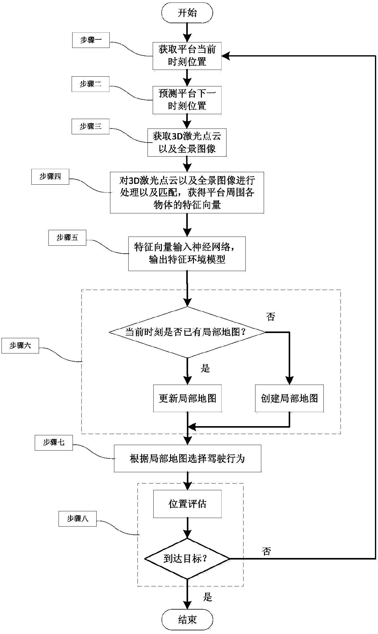
[0031] The present invention provides a method for constructing and navigating a geographic environment map based on data mining. The process of the method is as follows: figure 1 shown:

[0032] Step 1: Obtain the 3D laser point cloud and panoramic image of the surrounding environment of the ground unmanned mobile platform at the current moment, in which the vehicle 3D laser radar can be used to obtain the 3D laser point cloud, and the panoramic camera can be used to obtain the panoramic image.

[0033] The above-mentioned 3D laser point cloud is the feature point set of the surrounding environment of the platform, including the three-dimensional coordinate value and reflectivity of each feature point.

[0034] The panoramic camera in this embodiment includes five direction cameras, collects and obtains five images, and obtains a 360-degree panoramic ...


PUM


Abstract

The invention discloses a geographical environmental characteristic map construction and navigation method based on data mining, and belongs to the field of automatic control. The method comprises the following flow: firstly performing processing and matching on a current 3D laser-point cloud of the surrounding environment of a platform and a panoramic picture, to acquire characteristic vectors of each object in the platform surrounding environment; secondly inputting the characteristic vectors of each object into a neural network which classifies the characteristic vectors and outputs a characteristic environmental model; thirdly according to the characteristic environmental model, establishing a current local map or updating an original local map; and finally based on a current position of the platform and a predicted next-moment position, selecting a routine for driving according to the local map. If the platform does not reach a final goal, the flow is repeated; and if the platform reaches the final goal, the flow is finished and the final local map is a global map. The method is applicable to geographical environment map construction and navigation of a ground unmanned mobile platform.

Description

technical field [0001] The invention belongs to the field of automatic control, and in particular relates to a method for constructing and navigating a geographic environment map of a ground unmanned mobile platform. Background technique [0002] The ground unmanned mobile platform is a comprehensive system that integrates various functions such as environmental perception, dynamic decision-making and planning, behavior control and execution. The mobility and intelligence of the ground unmanned mobile platform depends on its autonomous navigation capability, and the accurate and fast autonomous navigation function is based on the precise geographic environment map information. Therefore, the study of advanced geographic environment map construction and navigation methods can enhance the intelligence of the ground unmanned mobile platform and open up a situation for its modern application. [0003] The existing geographic environment map construction and navigation methods b...

Claims


Application Information

Patent Timeline
IPC IPC(8): G01C21/34G09B29/00
Inventor 彭佳王美玲杨毅张毅杨强荣
Owner BEIJING INSTITUTE OF TECHNOLOGYGY
Why Eureka
Try Eureka