Forest fire positioning method and device based on two-dimensional images

A two-dimensional image, positioning method technology, applied in the direction of fire alarms, fire alarms, character and pattern recognition that rely on radiation, can solve the problem of inability to accurately calibrate the location of the fire source, and improve the efficiency of ignition , the effect of reducing construction costs

Active Publication Date: 2013-11-20
GUANGDONG ACAD OF FORESTRY +1
View PDF8 Cites 10 Cited by
  • Summary
  • Abstract
  • Description
  • Claims
  • Application Information

AI Technical Summary

Problems solved by technology

[0006] One purpose of the present invention is to solve the problem of inability to accurately calibrate the location of the fire s

Method used


Image

  • Forest fire positioning method and device based on two-dimensional images
  • Forest fire positioning method and device based on two-dimensional images
  • Forest fire positioning method and device based on two-dimensional images

Examples


Embodiment Construction

[0047] The technical solutions of the present invention will be further described below in conjunction with the accompanying drawings and embodiments.

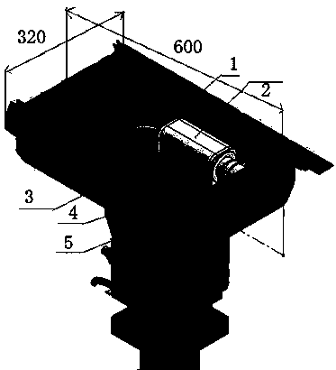
[0048] figure 1 Among them, 1-housing, 2-fog penetrating camera, 3-infrared thermal imager, 4-lens, 5-NC platform.

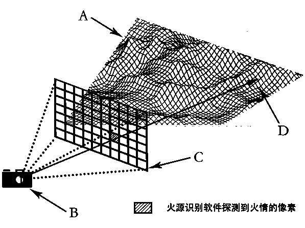
[0049] image 3 Among them, A-Digital Elevation Model (DEM), B-The position of the infrared thermal imager equipment in the digital elevation model, C-Two-dimensional infrared heat map field of view, D-By simulating reverse projection and hitting the mountain body fire point position.

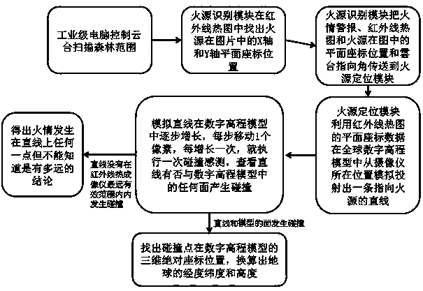
[0050] Such as figure 2 As shown, a forest fire location method based on two-dimensional images includes the following steps:

[0051] Establish a global digital elevation model and put the global digital elevation model in the back-end processor: according to the height data of the earth's surface, a spherical point cloud is formed, and every three adjacent points form a triangular surface, which is combined into a global ...


PUM


Abstract

The invention relates to the fields of forest fireproof monitoring and field environment monitoring technology, in particular to a forest fire positioning method and a forest fire positioning device based on two-dimensional images. The positioning method comprises that an image collector acquires position information, a fire source identification module identifies fire behavior information from the position information and transmits the fire behavior information to a rear-end processor, and a fire behavior positioning module in the rear-end processor locates the position of the fire source. The method and device of the invention can accurately locate a forest fire hazard with the error no more than +/-50m in the range of 5km, thereby providing accurate and timely information for forest fireproof management staff, and improving fire-fighting efficiency. Compared with a parallax positioning method requiring two infrared thermal imagers, the method and device of the invention can carry out accurate positioning with only one infrared thermal imager, thereby greatly reducing construction cost of a forest fire hazard monitoring system. The positioning method runs automatically, and can accurately position a forest fire within seconds needless of human assistance.

Description

[0001] technical field [0002] The present invention relates to the technical field of forest fire monitoring and field environment monitoring, and more specifically, to a method and device for locating forest fires based on two-dimensional images. Background technique [0003] Forest is the subject of terrestrial ecology, has very important ecological value and economic value, and is a very precious resource for human beings. However, in recent years, forest resources have decreased sharply. In addition to human-induced destruction, forest fires are the main reason for the reduction of forest resources. Therefore, the research on forest fire prevention measures has been paid attention to all over the world. [0004] my country's forest fire prevention has also gone through many different stages. The initial forest fire prevention work was mainly realized by setting up special staff to patrol the forest. Obviously, the real-time performance of this manual patrol is not hi...

Claims


Application Information

Patent Timeline
IPC IPC(8): G08B17/00G08B17/12G06K9/00
CPCY02A40/28
Inventor 李小川李兴伟王振师周宇飞岑棓琛陈嘉浩曾宇
Owner GUANGDONG ACAD OF FORESTRY
Why Eureka
Try Eureka