
Device and method for transmitting remote data of water temperature of ground water level

A technology of remote data transmission and groundwater level, which is applied in the field of devices for real-time remote transmission of groundwater level and temperature data. The application of batteries and the effect of ensuring normal power supply

Active Publication Date: 2014-01-01
CENT FOR HYDROGEOLOGY & ENVIRONMENTAL GEOLOGY CGS
View PDF10 Cites 11 Cited by
  • Summary
  • Abstract
  • Description
  • Claims
  • Application Information

AI Technical Summary

Problems solved by technology

Most of the existing monitoring points are still based on manual measurement, the degree of automation is low, and the monitoring accuracy is poor, which is far from meeting the requirements of monitoring the development and utilization of groundwater and the dynamic evaluation of groundwater
Although automatic monitors are installed in a few areas, they generally work in the way of regular on-site extraction. Real-time monitoring of the operating status of the monitoring instruments (working status, battery status, data storage, etc.) cannot be carried out. If there is a fault, it can only be discovered and eliminated when professional monitoring personnel take data, which will cause the loss of monitoring data and seriously affect the integrity and quality of groundwater monitoring
In addition, when the monitoring frequency needs to be adjusted in time due to emergencies, the existing equipment requires staff to go to the field to make adjustments, and the emergency response capability is poor.
There is a gap between the existing domestic monitoring instruments and foreign developed countries, mainly in the long-term stability of the instruments and high power consumption; the production process is not standardized, and the quality is difficult to control in mass production

Method used


Image

  • Device and method for transmitting remote data of water temperature of ground water level
  • Device and method for transmitting remote data of water temperature of ground water level
  • Device and method for transmitting remote data of water temperature of ground water level

Examples


Embodiment Construction

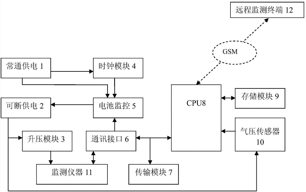
[0048] refer to figure 1 As shown, the groundwater level and water temperature remote data transmission device of the present invention includes: a group of water level and temperature monitors 11, an air pressure sensor 10 for monitoring the atmospheric pressure of the on-site environment, a communication interface module 6, and a microcomputer for receiving data collected by the on-site monitoring equipment. A processor 8, a storage module 9 for storing collected data, a transmission module 7, a clock module 4, and a power supply unit for supplying power to the above-mentioned working units.

[0049] The power supply unit includes a power supply ( figure 1 not specifically shown in), a normally-on power supply module 1, a breakable power supply module 2 and a battery monitoring module unit 5; the power supply supplies power to the transmission module, and the power supply is connected to the For the normally-on power supply module and the interruptible power supply module, ...


PUM


Abstract

The invention provides a device and method for transmitting remote data of the water temperature of a ground water level. The device comprises field monitoring equipment, a communication interface module, a microprocessor, a transmission module, a clock module and a power unit, wherein the clock module is used for providing a clock benchmark for the device, and the power unit is used for providing power for all the working units. The power unit comprises a power supply, a normally-opened power module, an interruptable power module and a battery monitoring module unit. The power supply directly provides power for the transmission module and is connected to the normally-opened power module and the interruptable power module respectively after two times of voltage stabilization. The normally-opened power supply provides working voltage for a microcontroller, a real-time clock, a communication interface and a battery monitoring unit. The interruptable power module provides working voltage for a water level monitor, a water temperature monitor and an air pressure sensor. The battery monitoring module unit is used for monitoring the working state of the interruptable power module. The device not only can carry out real-time monitoring and remote control on the running conditions of the monitoring instrument, but also can ensure that the power supply is switched off in a non-work state to reduce power consumption to the largest degree.

Description

technical field [0001] The invention belongs to the technical field of geological environment parameter monitoring, and in particular designs a device and method capable of real-time and remote transmission of groundwater level and temperature data. Background technique [0002] Groundwater is an important part of water resources. Groundwater plays an extremely important role in ensuring the safety of drinking water for the people, promoting economic and social development, and maintaining ecological balance. Geological disasters and ecological environmental problems such as groundwater level decline, land subsidence, karst subsidence, seawater intrusion, and land degradation have become important constraints to comprehensive, coordinated, and sustainable economic and social development. Most of the existing monitoring points are still based on manual measurement, with a low degree of automation and poor monitoring accuracy, which is far from meeting the requirements of moni...

Claims


Application Information

Patent Timeline
Patent Type & Authority Applications(China)
IPC IPC(8): G01D21/02G08C17/02
Inventor 史云冯建华张磊袁爱军
Owner CENT FOR HYDROGEOLOGY & ENVIRONMENTAL GEOLOGY CGS
Learn More