Map building method based on thermal infrared camera and laser range finder

A technology for laser range finder and map construction, applied in maps/plans/charts, instruments, measuring devices, etc., can solve problems such as low visibility, achieve the effects of eliminating noise interference, fast calculation speed, and narrowing the solution space

Active Publication Date: 2014-01-15
WUHAN UNIV OF SCI & TECH
View PDF6 Cites 44 Cited by
  • Summary
  • Abstract
  • Description
  • Claims
  • Application Information

AI Technical Summary

Problems solved by technology

[0005] The technical problem to be solved by the present invention is to provide a method and device for constructing a map based on a thermal infrared camera and a laser range finder, so as to solve the problem of constructing a map when the visibility is very low and there are occluders

Method used


Image

  • Map building method based on thermal infrared camera and laser range finder
  • Map building method based on thermal infrared camera and laser range finder
  • Map building method based on thermal infrared camera and laser range finder

Examples


Embodiment Construction

[0026] In order to make the technical solutions and advantages of the present invention clearer, the present invention will be further described in detail with reference to the accompanying drawings, not to limit its protection scope.

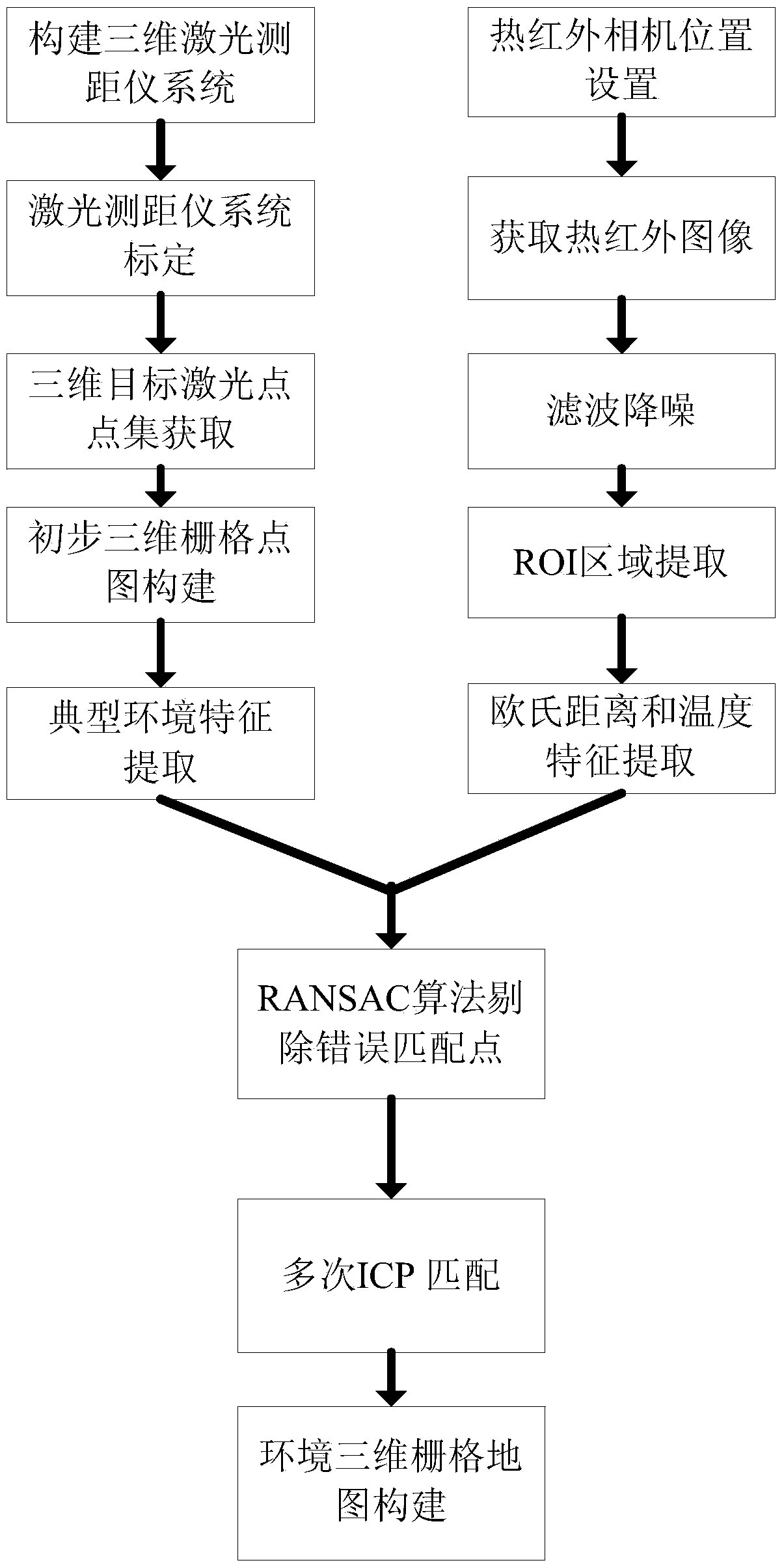
[0027] figure 1 An implementation flowchart of the system of the present invention is given. Such as figure 1 Shown, generally speaking, method of the present invention comprises the steps:

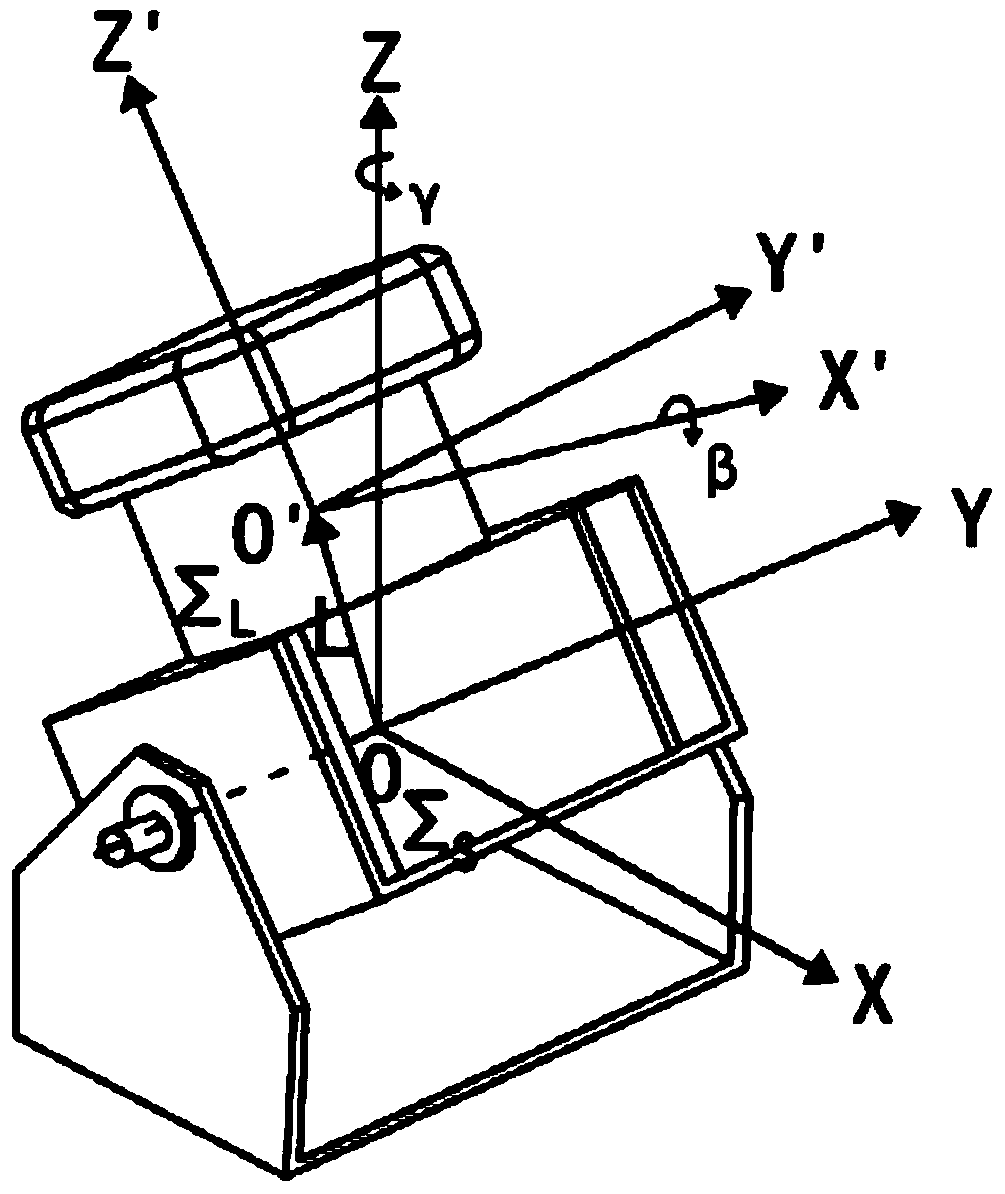
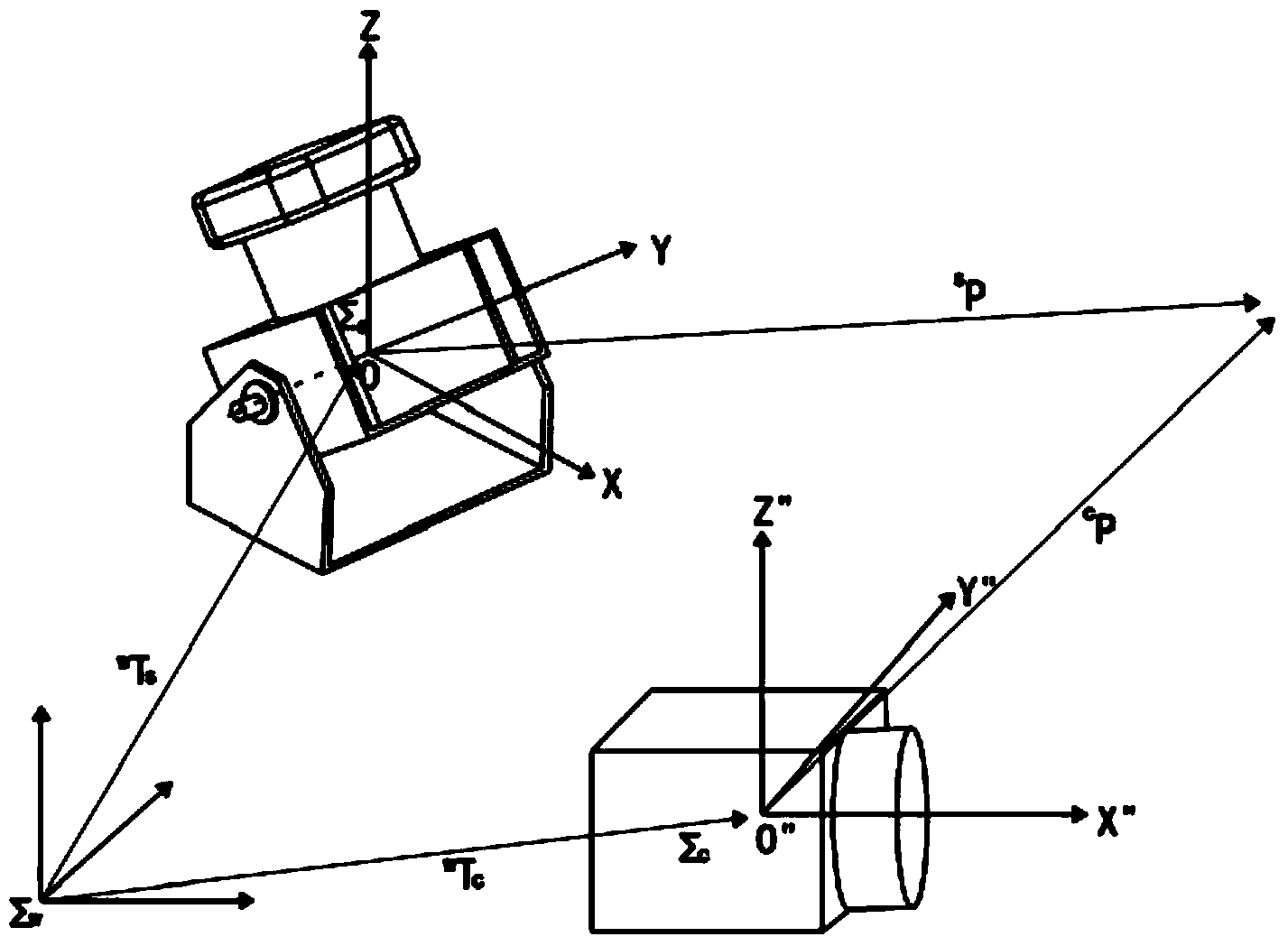
[0028] Step 1. Use the LMS200 laser rangefinder from SICK in Germany to cooperate with the free-rotating motor to build a 3D laser scanner, and use the laser rangefinder to scan the 3D scene. The 3D laser ranging system is composed of a small pan / tilt with a built-in motor and a LMS200 laser rangefinder. It is installed obliquely, and the built-in motor of the pan / tilt drives the laser. The present invention employs a rotating electrical connector contacted by mercury so that the rangefinder can rotate freely without twisting the cable. The three-dimen...


PUM


Abstract

The invention relates to a map building method based on a thermal infrared camera and a laser range finder. The method is characterized in that the problem that in the prior art, a map cannot be correctly built under the conditions of poor light condition and existence of a shielding object is effectively solved by acquiring a thermal infrared image of a target instead of acquiring the visible image of the target, and a rectangular frame containing the target is obtained by taking a variance weighted information entropy for interest area extracting, so as to reduce the learning space and remove huge noise jamming. According to the invention, the matched corresponding points of Euclidean distance and temperature are high in reliability, an RANSAC (random sample consensus) algorithm filters the corresponding points, so that the reliability of the corresponding points is improved to the greatest extent, and the matching calculation speed based on an ICP (iterative closest point) algorithm is high.

Description

technical field [0001] The invention relates to the field of real-time positioning and map construction of a mobile robot, in particular to the map construction of a mobile robot under conditions of low visibility and occluders. It can be used for a mobile robot to start from any position in an unknown area, estimate the pose of the robot and build an environmental map based on the perception data of the laser rangefinder and thermal infrared camera. Background technique [0002] With the development of robot technology, intelligent mobile robots with mobile walking function, environmental perception ability and trajectory planning ability have been paid more and more attention by researchers from all over the world. Realizing instant positioning and map construction (SimultaneousLocalization and Mapping, SLAM) is one of the most basic functions of intelligent robots, and it is also an important prerequisite for it to complete many tasks. [0003] Currently, in the applicat...

Claims


Application Information

Patent Timeline
Patent Type & Authority Applications(China)
IPC IPC(8): G01C21/32
CPCG01C21/005G09B29/005
Inventor 吴怀宇周致富
Owner WUHAN UNIV OF SCI & TECH
Why Eureka
Try Eureka