Ship-based image-stabilizing method based on sea-sky boundary detecting

A demarcation line, sea-sky technology, applied in image enhancement, image analysis, image communication and other directions, can solve the problem of not being able to be used as a reference for electronic image stabilization matching, and achieve the effect of reducing computational burden and improving computational efficiency

Active Publication Date: 2014-01-15
BEIJING INST OF ENVIRONMENTAL FEATURES
View PDF3 Cites 8 Cited by
  • Summary
  • Abstract
  • Description
  • Claims
  • Application Information

AI Technical Summary

Problems solved by technology

For the sea-based system, neither the clouds in the sky nor the large number of waves on the sea can be used as the matching reference

Method used


Image

  • Ship-based image-stabilizing method based on sea-sky boundary detecting
  • Ship-based image-stabilizing method based on sea-sky boundary detecting
  • Ship-based image-stabilizing method based on sea-sky boundary detecting

Examples


Example Embodiment

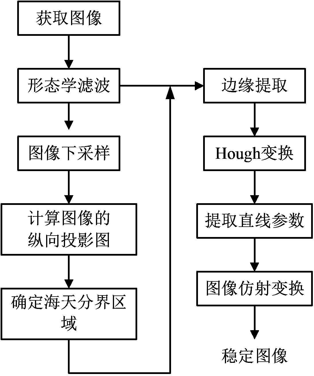
[0035] The shipborne image stabilization method based on the sea-sky boundary line detection of the present invention will be described in detail below with reference to the accompanying drawings and embodiments.

[0036] The shipborne image stabilization method based on sea-to-sky boundary detection of the present invention includes the following steps:

[0037] step 1

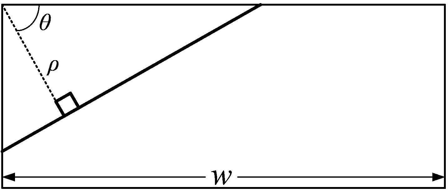
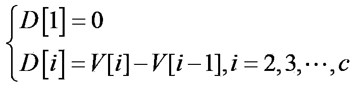
[0038] Set the reference position of the Haitian dividing line in the image, and set the reference position as required. In this embodiment, the reference position is set as the longitudinal center of the image, which is parallel to the horizontal direction of the image. The width of the image is w pixels and the height is h pixels, that is, the reference position is set to h / 2 in this embodiment.

[0039] Step 2

[0040] Obtain the surveillance video image frame with the boundary line between the sea and the sky through the shipboard camera. The current frame image is marked as I, and I is the gray-scale image.

[00...


PUM


Abstract

The invention belongs to the field of image processing and photoelectricity and particularly relates to a ship-based image-stabilizing method based on sea-sky boundary detecting. The method comprises the following steps that denoising and down-sampling processing are carried out on surveillance video image frames; longitudinal projection vectors of down-sampling images are established, the changing rate vectors of the longitudinal projection vectors are obtained, the changing rate highest point is extracted as a sea-sky boundary reference position; a zone comprising the sea-sky boundary reference position is intercepted at a certain height in an initial image; edge extracting and Hough converting are carried out on the zone in sequence, the maximum value in a Hough zone is a straight line parameter of the sea-sky boundary; the initial image is subjected to horizontal moving and rotating converting according to the straight line parameter of the sea-sky boundary, and converting results are used as an image-stabilizing result image to be output. According to the method, influence caused by noise of a sea surface and sky can be effectively removed, the position of the sea-sky boundary in the image can be accurately acquired, and an image-stabilizing function is achieved.

Description

technical field [0001] The invention belongs to the field of image processing and optoelectronic technology, and in particular relates to a shipborne image stabilization method based on sea-sky boundary detection. Background technique [0002] The shipboard photoelectric detection system is placed on a moving platform at sea. The platform itself will shake and shake to a certain extent under the influence of waves, which will cause image instability when the shipboard photoelectric detection system is imaging, which will affect the observer's detection of sea surface conditions. [0003] Sea-based electronic image stabilization systems are significantly different from road-based electronic image stabilization systems. There are a large number of rigid targets on land, which can be used as the benchmark of the electronic image stabilization system, and the method of image block matching is used to complete the global motion estimation of the image. For sea-based systems, nei...

Claims


Application Information

Patent Timeline
IPC IPC(8): G06T5/00H04N7/18G06T7/00H04N5/21
Inventor 柴智李亚鹏李香祯杨文佳
Owner BEIJING INST OF ENVIRONMENTAL FEATURES
Why Eureka
Try Eureka