Method for building mountainous area surface temperature base line and application

A surface temperature and baseline technology, applied in special data processing applications, instruments, electrical digital data processing, etc., can solve problems such as difficulties in exploring temperature laws in mountainous areas and poor representativeness of meteorological stations

A surface temperature and baseline technology, applied in special data processing applications, instruments, electrical digital data processing, etc., can solve problems such as difficulties in exploring temperature laws in mountainous areas and poor representativeness of meteorological stations

CN103530499AInactive Publication Date: 2014-01-22SOUTHWEST FORESTRY UNIVERSITY

Image

  • Method for building mountainous area surface temperature base line and application
  • Method for building mountainous area surface temperature base line and application
  • Method for building mountainous area surface temperature base line and application

Examples


Embodiment Construction

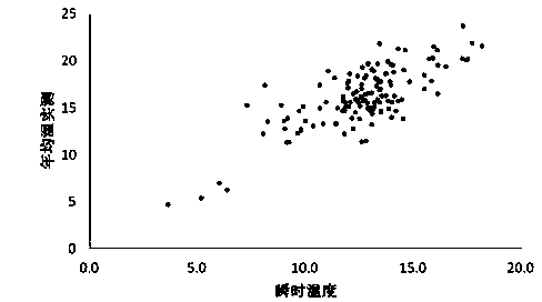
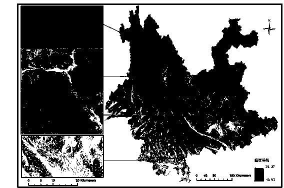
[0032] (1) Acquisition of ground surface temperature baseline

[0033] (1) Remote sensing image preprocessing

[0034] The remote sensing instantaneous temperature field was retrieved using MODIS images of Yunnan Province acquired by AMSTAR TERRA at 12:11 on November 12, 2005. MODIS image preprocessing includes stripe noise removal, data overlap phenomenon removal, radiation product calculation, solar zenith angle correction, and geometric correction. The breakdown is as follows:

[0035] Stripe noise elimination: the neighborhood difference method is used, that is, the average value of the gray value of the 6 non-noise pixels around the noise pixel is used to replace the gray value of the noise pixel. Assuming a noise pixel, subtract it from the average value of 6 adjacent non-noise pixels, and divide by the average value. If the value is greater than the set threshold T, it is noise. The judgment formula for noise:

[0036]

[0037] Where For the first Line Column pixel gray v...


PUM


Abstract

The invention discloses a method for building a mountainous area surface temperature base line and application, and relates to the measurement and application of mountainous area surface temperature base lines. A transient temperature field distributed continuously in MODIS thermal infrared remote sensing image inversion spaces is combined with longitude and latitude raster data to build the annual average temperature linear estimation model of a weather station as the calibration model of the transient surface temperature field. The model corrects the transient temperature field to obtain the mountainous area surface temperature base line. In YunnanProvince with the mountain landform as the main landform, the temperature base line with a 90m*90m grid as a unit is built, the temperature distribution characteristics and rules of the area are reflected, and the average temperature base line value of a 90m*90m land parcel can be found out in a quantitative mode. The temperature base line is used as basic data to be combined with an expert scoring method to respectively build a Yunnan Province pine wilt disease occurrence risk pre-warning model and a Yunnan Province forest fire danger long-term forecast model.

Description

Technical field [0001] The invention belongs to the measurement of geographic temperature characteristic values, especially the measurement and application of ground surface temperature baselines. Background technique [0002] Surface temperature is a key factor in many ecological environmental processes, and its changing law is the basic content of the establishment and practical application of theories in meteorology, hydrology, ecology, forestry and other fields. The traditional method is based on the meteorological station observation data as sample data, using interpolation method, temperature lapse rate correction method, multiple regression method and other methods of geographic information system to carry out temperature rasterization research. Essentially, it is made by applying statistical methods. The model lacks the realistic meaning of physical temperature simulation. Even if there is a correction model based on environmental gradient factors such as altitude and la...

Claims


Application Information

Patent Timeline
22 Jan 2014
Publication
CN103530499A
IPC
G06F19/00
Inventors
ηŽ‹θ‰³ιœž; 周汝良