Absolute navigation filtering method capable of estimating drifting of accelerometer

An accelerometer and acceleration technology, which is applied in navigation, surveying and navigation, integrated navigator, etc., can solve the problems of large amount of calculation and difficulty in entering the engineering application stage, and achieve the effect of improving accuracy and reducing the amount of calculation on the planet

Active Publication Date: 2014-01-29
SHANGHAI AEROSPACE CONTROL TECH INST
View PDF4 Cites 10 Cited by
  • Summary
  • Abstract
  • Description
  • Claims
  • Application Information

AI Technical Summary

Problems solved by technology

[0003] At present, there are many theoretical researches on the integrated navigation technology based on iner

Method used


Image

  • Absolute navigation filtering method capable of estimating drifting of accelerometer
  • Absolute navigation filtering method capable of estimating drifting of accelerometer
  • Absolute navigation filtering method capable of estimating drifting of accelerometer

Examples


Embodiment Construction

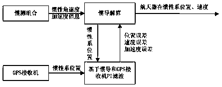
[0049] based on the following figure 1 Preferred embodiments of the present invention will be described in detail.

[0050] Such as figure 1 As shown, the present invention provides a kind of absolute navigation filtering method of estimating accelerometer drift, and this method comprises the following steps:

[0051] Step 1. According to the angular velocity and acceleration output by the inertial measurement combination (including accelerometer and gyroscope), perform inertial navigation calculation, output the position and velocity information of the spacecraft in the inertial coordinate system, and use Xsins to represent the spacecraft in the inertial coordinate system position and velocity information of

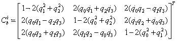
[0052] Step 1.1, obtain the attitude quaternion of the body coordinate system relative to the inertial coordinate system:

[0053] The origin of the body coordinate system is at the center of mass of the spacecraft, the X-axis points to the flight direction of the sp...


PUM


Abstract

The invention relates to an absolute navigation filtering method capable of estimating drifting of an accelerometer. A GPS (Global position system) receiver is adopted to output position information, the PI type filtering technology is adopted to estimate the position error, the speed error and the acceleration error, Kalman filtering calculation is omitted, the satellite calculation amount is greatly simplified and the acceleration error is estimated, and therefore, the absolute navigation filtering method has the beneficial effects that the inertial navigation recurrence precision can be improved, the autonomous navigation precision is remarkably improved, the engineering practicability is improved, the new thought for autonomous navigation is acquired, the application to deep space exploration soft landing can be expanded and the like.

Description

technical field [0001] The invention relates to an absolute navigation technology based on inertial navigation and GPS receivers, in particular to an absolute navigation filtering method for estimating accelerometer drift. Background technique [0002] Carrying out research on autonomous navigation technology of spacecraft can reduce the workload of ground stations and alleviate the difficulty of ground measurement and control station layout caused by geographical restrictions; secondly, since autonomous navigation can determine the position of satellites in time, it can improve the utilization rate of satellite observation data, Its practical significance is particularly obvious by enhancing the flexibility and accuracy of satellites when performing missions, improving the survivability of satellites, and maintaining the continuity of missions even when the ground tracking measurement is interrupted. [0003] At present, there are many theoretical researches on the integrat...

Claims


Application Information

Patent Timeline
IPC IPC(8): G01C21/20
CPCG01C21/165G01C21/20G01C21/24G01C25/005
Inventor 王献忠张丽敏施常勇
Owner SHANGHAI AEROSPACE CONTROL TECH INST
Why Eureka
Try Eureka