Three-dimensional multi-UAV coordinated path planning method based on sparse A-star search (SAS)

A track planning and track technology, which is applied in three-dimensional position/track control, navigation calculation tools, special data processing applications, etc., and can solve problems such as time-consuming

Inactive Publication Date: 2014-02-05
HARBIN ENG UNIV
View PDF3 Cites 58 Cited by
  • Summary
  • Abstract
  • Description
  • Claims
  • Application Information

AI Technical Summary

Problems solved by technology

Since the SAS algorithm is a global planning method, its planning time increases with the increase of the planning area. When the planning area is large an...

Method used


Image

  • Three-dimensional multi-UAV coordinated path planning method based on sparse A-star search (SAS)
  • Three-dimensional multi-UAV coordinated path planning method based on sparse A-star search (SAS)
  • Three-dimensional multi-UAV coordinated path planning method based on sparse A-star search (SAS)

Examples


Embodiment 1

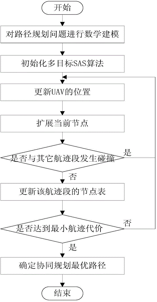
[0052] A three-dimensional multi-UAV cooperative trajectory planning method based on sparse A* search, which specifically includes the following steps.

[0053] Step 1: Mathematical modeling of the path planning environment

[0054] Threat space modeling, as one of the key technologies of trajectory planning, is the data recording space for terrain, landform and ground threat distribution, and is the information source and calculation basis for trajectory planning. Digital maps use digital technology to store information such as terrain and landforms in the form of data, so that they can be called by various electronic devices of the aircraft.

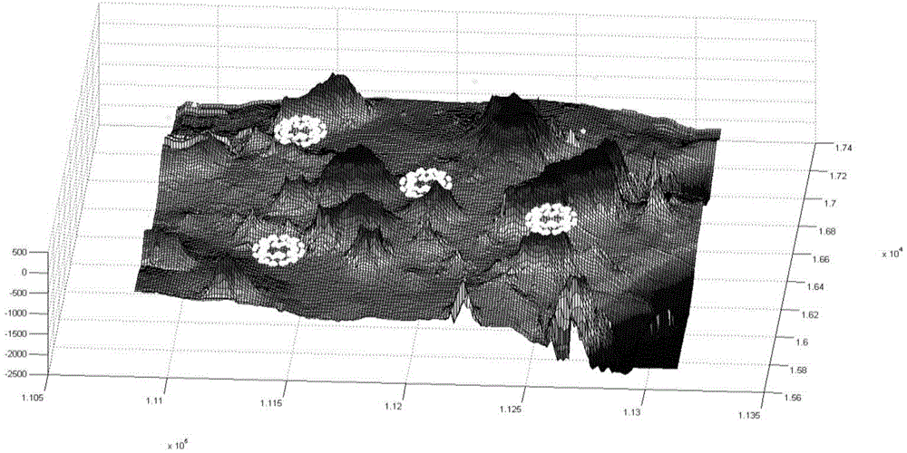
[0055] What is used in this patent is a 200*200 pixel digital elevation map generated from real terrain in the range of 500km*500km, and the real terrain distance between adjacent pixels is 2.5km. (See figure 2 )

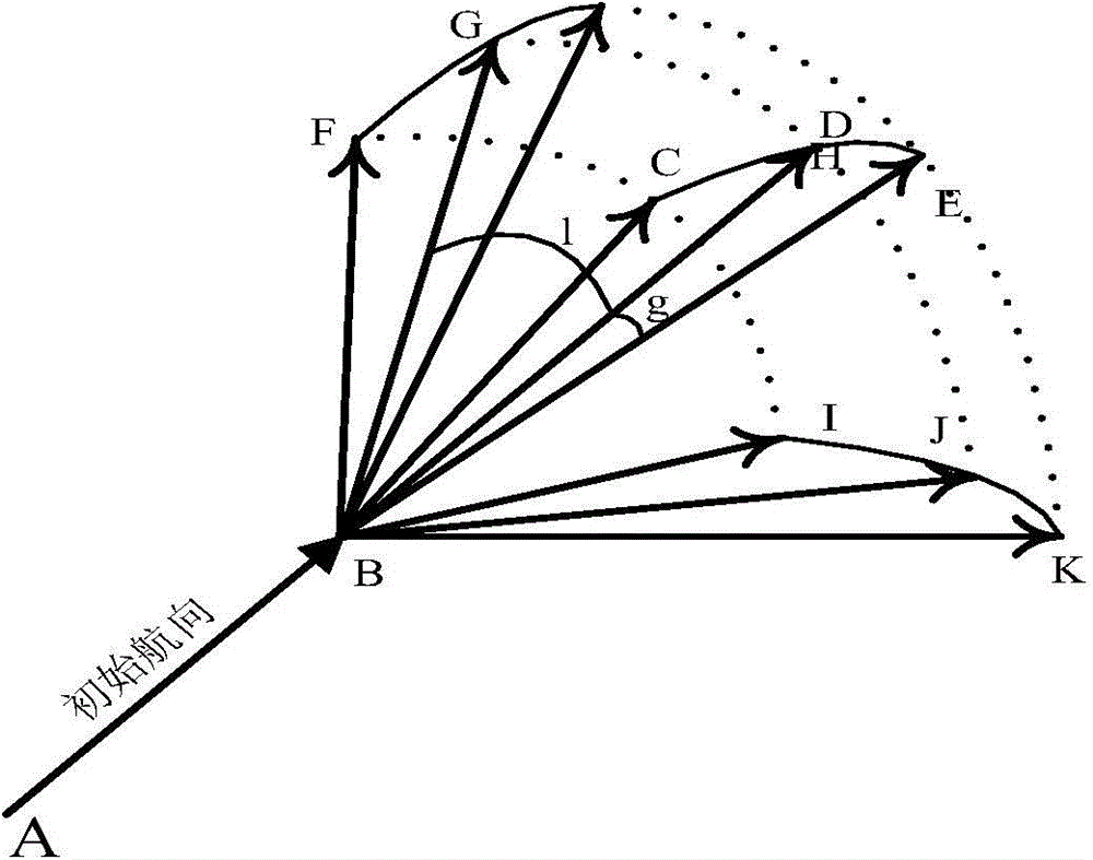
[0056] Path planning is carried out in three-dimensional space, S is the starting point of the UAV, G is the end point...

Embodiment 2

[0107] The present invention proposes a multi-UAV collaborative track planning method based on sparse A* search, such as figure 1 As shown, it specifically includes the following steps.

[0108]Step 1: Mathematical modeling of the path planning environment

[0109] Threat space modeling, as one of the key technologies of trajectory planning, is the data recording space for terrain, landform and ground threat distribution, and is the information source and calculation basis for trajectory planning. Digital maps use digital technology to store information such as terrain and landforms in the form of data, so that they can be called by various electronic devices of the aircraft.

[0110] What is used in this patent is a 200*200 pixel digital elevation map generated from real terrain in the range of 500km*500km, and the real terrain distance between adjacent pixels is 2.5km. (See figure 2 )

[0111] Path planning is carried out in three-dimensional space, S is the starting po...

Embodiment 3

[0159] Aiming at the problems existing in the prior art, the present invention improves the basic A* algorithm, and proposes a multi-UAV cooperative track planning method based on the SAS algorithm. The method provided by the invention is distinguished from the existing methods by the following notable features: firstly, the SAS method is extended to three-dimensional space, and a three-dimensional track planning algorithm is provided. The algorithm makes full use of the three-dimensional information of the planning environment, and can effectively avoid terrain and threats. Experiments prove that the algorithm is fast and effective, and the planned track has the ability to automatically avoid terrain and threats, which is better than two-dimensional track. Second, the present invention aims at the problem of multi-objective path planning, and considers multiple path performance indexes in the planning at the same time, so that a set of optimal solution sets can be obtained in...


PUM


Abstract

The invention belongs to the field of path planning technology and specifically relates to a three-dimensional multi-UAV coordinated path planning method based on SAS. The method comprises the following steps: carrying out modeling on a path planning environment; initializing multi-target SAS calculation parameters consisting of the length of a minimum path section, a maximum turning angle, a maximum angle of climb/glide, a minimum safe distance of UAVs and a minimum flight altitude of UAVs; initializing the positions of the UAVs, wherein each UAV represents a path; updating the positions of the UAVs; expanding a current node; determining whether a path section collides with other path sections; updating a node table of the path section; executing a step (8) if minimum path cost set in the step (2) is met, and otherwise, executing the step (3); determining a cooperated planned optimal path so as to complete path planning. The method overcomes multi-objective optimization problems, has versatility, provides a reasonable optimal solution for a decision maker and better accords with practical needs.

Description

technical field [0001] The invention belongs to the technical field of path planning, and in particular relates to a multi-UAV cooperative track planning method based on sparse A* search. Background technique [0002] As one of the cores of the mission planning system, trajectory planning is a high-tech developed with modern information technology. It searches for a flight trajectory from the initial position to the target position under certain constraints and meets certain performance indicators. UAV trajectory planning is a key technology to realize the autonomous navigation of aircraft. It is of great significance both in theory and in practical application. It is one of the important research directions in the field of artificial intelligence and navigation and guidance. Aircraft safety penetration technology has experienced from terrain following technology, terrain following / terrain avoidance integrated technology to the current trajectory planning technology. The te...

Claims


Application Information

Patent Timeline
IPC IPC(8): G01C21/20G05D1/10G06F17/50
CPCG05D1/101
Inventor 刘利强顾海超杨裕杰戴运桃李宁齐昭汪相国张凯赵明孟欣冉
Owner HARBIN ENG UNIV
Why Eureka
Try Eureka