High-performance star-map matching autonomous navigation positioning system

An autonomous navigation and star map technology, applied in the field of navigation systems, can solve problems such as unreasonable resource allocation, incomplete supporting technology, disconnection between theoretical research and engineering implementation, and achieve the effect of improving accuracy and adaptability

Inactive Publication Date: 2014-02-12
PLA DALIAN NAVAL ACADEMY
View PDF8 Cites 17 Cited by
  • Summary
  • Abstract
  • Description
  • Claims
  • Application Information

AI Technical Summary

Problems solved by technology

[0013] Due to the lag in support theory, existing equipment can only use the sun to find direction during the day, and the positioning of a single celestial body requires the sun's azimuth to change by more than 30 degrees, and a positioning takes two to three hours, so it is difficult to ensure the timeliness of positioning. It is more difficult to achieve continuous positioning, so that the superior navigation method of celestial navigation can only be used as a correction device for inertial navigation
[0014] 5) The supporting technology is not perfect enough
[0017] Theoretical research is out of touch with engineering realization, and resource allocation is not reasonable, which seriously affects the development of celestial navigation technology

Method used


Image

  • High-performance star-map matching autonomous navigation positioning system
  • High-performance star-map matching autonomous navigation positioning system

Examples


Embodiment Construction

[0041] Below in conjunction with accompanying drawing, further elaborate the present invention. It should be understood that these examples are only used to illustrate the present invention and are not intended to limit the scope of the present invention. In addition, it should be understood that after reading the teachings of the present invention, those skilled in the art can make various changes or modifications to the present invention, and these equivalent forms also fall within the scope defined by the appended claims of the present application.

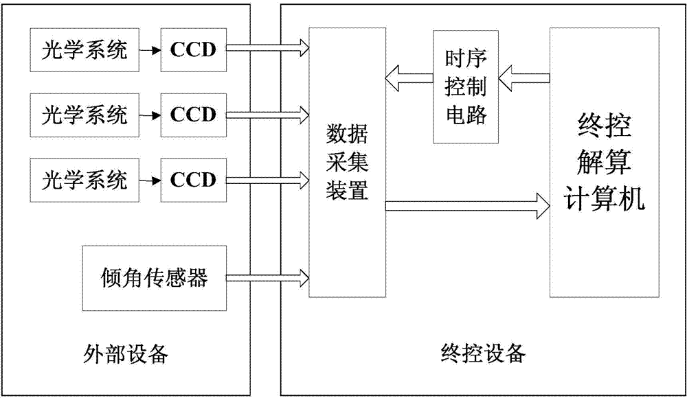
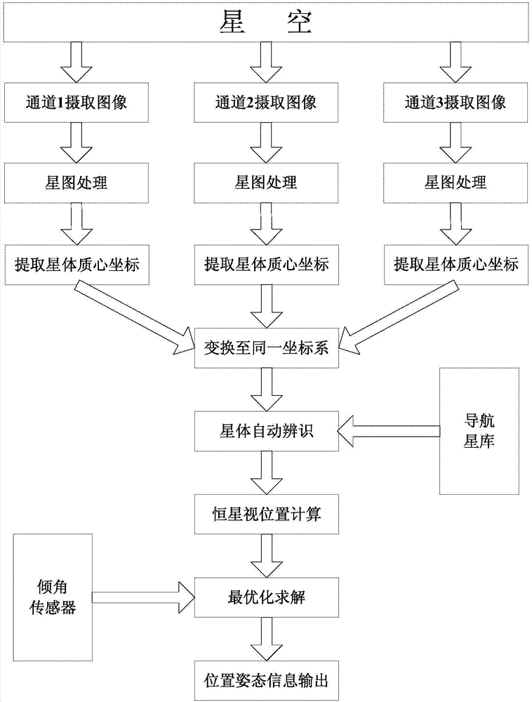
[0042] Such as figure 1As shown, each measurement channel of the star sensor is composed of mutually independent optical telescopic lens and CCD camera. Each channel is raised at a certain angle above the base plane of the equipment, and the projection lines on the base plane differ from each other by 120°. The field of view is relatively small, while the angular resolution is relatively high. For the three sets of discrete m...


PUM


Abstract

The invention discloses a star-map matching autonomous navigation positioning system which comprises a star sensor, a tilt angle sensor, a data acquisition device and a terminal computer, wherein the star sensor is used for obtaining a star map; the tilt angle sensor is used for obtaining tilt angle information of the x axis and the y axis of a platform; the data acquisition device is used for acquiring data detected by the star sensor and the tilt angle sensor and sending the data to the terminal computer; a time sequence control circuit is used for controlling acquisition frequency and synchronization; the terminal computer is in charge of sending an instruction and making a final calculation, and comprises a star map image processing and barycentric coordinate extracting module, an image space coordinate conversion module, a star body identification module, an apparent position calculation module and an optimal calculation module.

Description

technical field [0001] The invention relates to a navigation system, in particular to a ship autonomous navigation system. Background technique [0002] Satellite navigation technology, including global satellite navigation and regional satellite navigation, is the main mode of modern navigation. The common feature is that specific beacons broadcast navigation messages in specific formats at specific frequencies, and the navigation signals are extremely weak. The technical characteristics of "three certainties and one weakness" determine that the satellite navigation system is vulnerable to attack and manipulation. Ground-based radio navigation systems have limited range, service blind spots, low long-range navigation accuracy, and are vulnerable to attacks, so their application and development are limited. As an autonomous navigation method, inertial navigation has broad development and application space, but it is difficult to use as an independent high-precision navigati...

Claims


Application Information

Patent Timeline
Patent Type & Authority Applications(China)
IPC IPC(8): G01C21/02
CPCG01C21/02G01C21/06G01C21/203
Inventor 王安国
Owner PLA DALIAN NAVAL ACADEMY
Why Eureka
Try Eureka