Regional Wireless Positioning and Positioning Method of Micro Strapdown Inertial Navigation System

A wireless positioning system and wireless positioning technology, used in navigation, mapping and navigation, measurement devices, etc., can solve the problems of limited precise positioning, lack of communication ability, affecting accuracy, etc., to improve regional positioning accuracy and anti-interference. ability, make up for the slow data update rate, and suppress the effect of signal jumps

Active Publication Date: 2016-06-29
NAVAL UNIV OF ENG PLA
View PDF2 Cites 0 Cited by
  • Summary
  • Abstract
  • Description
  • Claims
  • Application Information

AI Technical Summary

Problems solved by technology

(1) Infrared rays have relatively high indoor positioning accuracy, but require no occlusion between positioning objects. In addition, infrared rays are only suitable for short-distance transmission, and are easily interfered by fluorescent lamps or lights in the room, which has limitations in precise positioning; (2) The overall positioning accuracy of ultrasonic positioning is high and the structure is simple, but it also requires no obstruction between the measured objects. Ultrasonic waves are greatly affected by multipath effects and non-line-of-sight propagation. At the same time, a large amount of investment in underlying hardware facilities is required, and the cost Too high; (3) The biggest advantage of Bluetooth indoor positioning technology is the small size of the equipment, but the price of Bluetooth devices and equipment is relatively expensive, and for complex space environments, a single unit of the Bluetooth system has a short range, poor stability, and interference by noise signals Big
(4) Radio frequency identification technology uses radio frequency to carry out non-contact two-way communication and exchange data to achieve the purpose of identification and positioning. Information with centimeter-level positioning accuracy can be obtained within a few milliseconds. The cost is also low, but the action distance is short and does not have (5) Wi-Fi technology is widely used in small-scale indoor positioning, and the cost is low, but whether it is used for indoor or outdoor positioning, Wi-Fi transceivers are only It can cover an area within a radius of 90 meters, and is easily interfered by other signals, thereby affecting its accuracy, and the energy consumption of the locator is also high

Method used


Image

  • Regional Wireless Positioning and Positioning Method of Micro Strapdown Inertial Navigation System
  • Regional Wireless Positioning and Positioning Method of Micro Strapdown Inertial Navigation System

Examples


Embodiment Construction

[0032] Below in conjunction with accompanying drawing and specific embodiment the present invention is described in further detail:

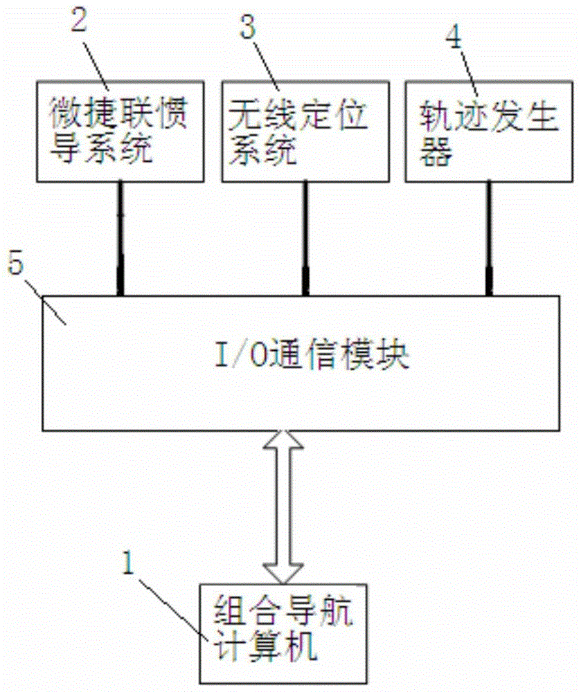
[0033] The regional wireless positioning and micro-strapdown inertial navigation combined system shown in Figure 1 includes a combined navigation computer 1, a micro-strapdown inertial navigation system 2, a wireless positioning system 3 and a trajectory generator 4, wherein the micro-strapdown inertial navigation The communication terminals of the system 2 , the wireless positioning system 3 and the track generator 4 are respectively connected with the communication terminal of the integrated navigation computer 1 .

[0034] In the above technical solution, the strapdown inertial navigation system 2 , the wireless positioning system 3 and the trajectory generator 4 are respectively connected to the integrated navigation computer 1 through the I / O communication module 5 .

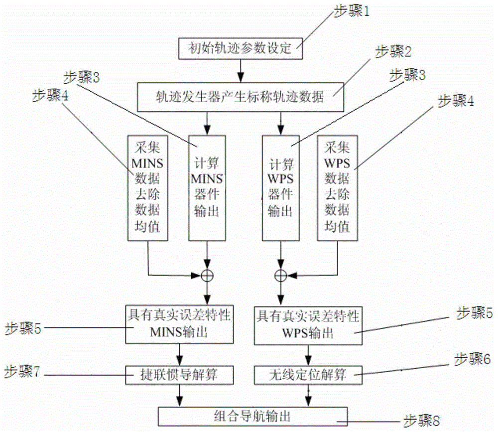
[0035] A positioning method utilizing the above-mentioned regional wirel...


PUM


Abstract

The invention discloses a regional wireless positioning and micro-serial inertial navigation integrated system and a positioning method thereof. The system comprises an integrated navigation computer, a micro-serial inertial navigation system, a wireless positioning system and a track generator, wherein communication terminals of the micro-serial inertial navigation system, the wireless positioning system and the track generator are respectively connected with a communication terminal of the integrated navigation computer. According to the regional wireless positioning and micro-serial inertial navigation integrated system, the advantages of each of the micro-serial inertial navigation system and the wireless positioning system can be exerted and the defects of the other system can be made up, so that the regional positioning accuracy and anti-jamming capability of the whole system are improved.

Description

technical field [0001] The invention relates to the technical field of positioning and navigation methods, in particular to an area wireless positioning and micro-strapdown inertial navigation combined system and its positioning method. technical background [0002] In recent years, there has been an increasing demand for indoor positioning. Indoor positioning is becoming more and more important for public life. For example, in supermarkets, by obtaining the personal location information of consumers and the location information of target products, route guidance can be carried out to realize intelligent shopping guide; in sudden disasters, indoor positioning can be used to guide rescuers Rescue trapped people in the building as quickly as possible; in hospitals, monitor patients and manage medical equipment. Realizing low-cost, high-precision indoor positioning has very important practical significance. [0003] The GPS (Global Positioning System, Global Positioning Syste...

Claims


Application Information

Patent Timeline
Patent Type & Authority Patents(China)
IPC IPC(8): G01C21/00
CPCG01C21/165G01C21/206
Inventor 傅军朱涛张亚宁
Owner NAVAL UNIV OF ENG PLA
Why Eureka
Try Eureka