
Positioning system based on cloud computing technology and positioning method

A positioning method and positioning system technology, applied in the field of navigation and positioning, can solve problems such as the inability to assemble calculators, and achieve the effects of easy industrial development, reduced cost and power consumption, and reduced power consumption

Active Publication Date: 2014-06-11
TECHTOTOP MICROELECTRONICS
View PDF5 Cites 33 Cited by
  • Summary
  • Abstract
  • Description
  • Claims
  • Application Information

AI Technical Summary

Problems solved by technology

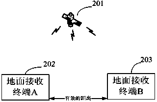
[0008] In the above existing architectures and modes, the user terminal usually directly calculates the position information locally according to the received navigation satellite signals, and the local calculation puts forward higher requirements on the computing power, power consumption and cost of the user terminal. Especially with the extensive development of location-based service applications and higher and higher requirements for positioning accuracy, more and more algorithms will be used and the data information required for calculation will increase. High-precision positioning in some fields requires long-term observation. With the help of the high-speed computing capability of the receiver processor, high-precision results can be obtained by post-processing, but the post-processing calculation method cannot meet the current requirements for positioning timeliness. Therefore, stand-alone local positioning or post-processing positioning, whether it is The computing power, power consumption, cost and timeliness are all facing more stringent requirements. However, the reality is that user terminals are often limited by their size and cost, and cannot be equipped with computing devices with too high a configuration. In order to improve their battery life, Also limit power loss

Method used


Image

  • Positioning system based on cloud computing technology and positioning method
  • Positioning system based on cloud computing technology and positioning method
  • Positioning system based on cloud computing technology and positioning method

Examples


Embodiment Construction

[0031] In order to make the object, technical solution and advantages of the present invention clearer, the present invention will be further described in detail below in conjunction with the accompanying drawings and embodiments. It should be understood that the specific embodiments described here are only used to explain the present invention, not to limit the present invention.

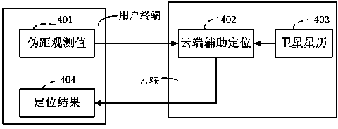
[0032] The present invention proposes a positioning system based on cloud computing. The system includes a user terminal 301, a cloud 303, and a communication data link 302 between the user terminal and the cloud, such as image 3As shown: when the user terminal 301 has a positioning requirement, the user terminal 301 sends positioning reference data to the cloud 303 through the communication data link 302, and the cloud 303 collects the information required for positioning from the cloud 303 according to the positioning request, and calculates a high-precision position information, and then retu...


PUM


Abstract

The invention aims at providing a positioning method based on cloud computing. The method comprises steps: 1, a user terminal transmits reference data to the cloud end; 2, the cloud end carried out position computation according to the reference data; and 3, the cloud end returns position information. When the technical scheme of the invention is adopted, the problems that the computing ability of the user terminal is insufficient, the power consumption during the operation is large, the computing time is long, the real-time precision of a single machine is not high and the like in the current high-precision positioning structure and mode can be solved. The user only needs to pay for little network service fee and quick, high-precision and real-time positioning results can be acquired. The user terminal can be freed from heavy positioning computation, thereby reducing the power consumption of the user terminal and improving the continuous navigation ability. Once the cloud end is built successfully, the system can be used for a long time. Flexible use modes are provided. For the user terminal, especially the terminal user of Beidou, the cost and the power consumption can be greatly reduced, and industrialization development of Beidou is facilitated.

Description

technical field [0001] The invention relates to a positioning system and a positioning method based on cloud computing technology, which are suitable for various GNSS global satellite navigation system receivers to realize navigation and positioning based on cloud computing. Background technique [0002] GNSS (Global Navigation Satellite System) is a general term for all navigation satellite systems worldwide, including GPS (Global Positioning System, US Global Positioning System), GLONASS (Russian Glonass Navigation Satellite System), Galileo (European Galileo navigation satellite system), Compass (China Beidou navigation satellite system), etc., all of the above navigation satellite systems are designed to provide users with satellite navigation and positioning services around the clock. The existing GNSS positioning system architecture and modes include the following: [0003] The user terminal receives the satellite signal broadcast by the navigation satellite, demodula...

Claims


Application Information

Patent Timeline
Patent Type & Authority Applications(China)
IPC IPC(8): G01S19/42
CPCG01S19/34G01S19/42
Inventor 刘丽宁吕海霞吴亚喆林木龙
Owner TECHTOTOP MICROELECTRONICS
Learn More