Assessment method for GNSS interoperability

A technology of interoperability and performance, applied in the field of satellite navigation systems, which can solve the problem of not forming an interoperability evaluation method.

Inactive Publication Date: 2014-07-02
HARBIN ENG UNIV
View PDF2 Cites 12 Cited by
  • Summary
  • Abstract
  • Description
  • Claims
  • Application Information

AI Technical Summary

Problems solved by technology

In terms of evaluation methods for GNSS interoperability performance, judging from the current international form, it is

Method used


Image

  • Assessment method for GNSS interoperability
  • Assessment method for GNSS interoperability
  • Assessment method for GNSS interoperability

Examples


Embodiment Construction

[0086] The present invention will be further described below in conjunction with the accompanying drawings.

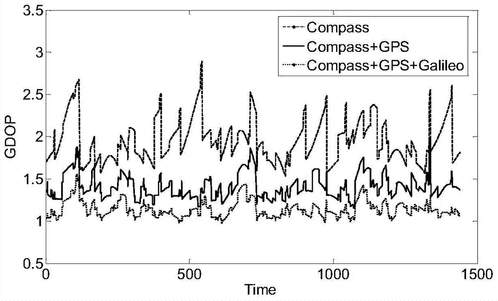
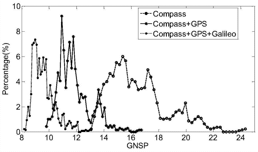
[0087] The present invention proposes a system-level GNSS interoperability performance evaluation method in order to evaluate the improvement degree of system service performance in a multi-satellite navigation system operation mode compared with a single system operation mode. Based on the proposed three system service performance evaluations of Geometric Factor of Precision, Geometric Positioning Accuracy, and Integrity, in order to unify GNSS performance, the availability and continuity of evaluation parameters are used to quantify them. In order to reflect the effect of the availability and continuity of different parameters on the performance evaluation of GNSS, the weighted method is used to obtain the weighted GNSS performance evaluation index. In order to achieve the above objectives, a system-level GNSS interoperability performance evaluation method is propose...


PUM


Abstract

The invention relates to an assessment method for GNSS interoperability, and belongs to the field of satellite navigation systems. The assessment method includes the steps that the position of a GNSS satellite is calculated according to an orbital element, the geometric dilution of precision (GDOP) of the GNSS satellite is calculated, geometric positioning of precision (GNSSP) of a GNSS is calculated, the integrity output parameter horizontal protection level (HPL) is calculated, usability of GNSS performance assessment parameters and continuity of the GNSS performance assessment parameters are calculated, weighted GNSS performance assessment indexes are calculated, single-point assessment interoperability is selected, and global-point assessment interoperability is selected. Along with the increase of the number of systems, the value of GNSSP probability density distribution central point is smaller, and distribution is more centralized.

Description

technical field [0001] The invention relates to a GNSS interoperability performance evaluation method, which belongs to the field of satellite navigation systems. Background technique [0002] GNSS (Global Navigation Satellite System, Global Navigation Satellite System) is the general term for all satellite navigation systems working in orbit, mainly including GPS in the United States, GLONASS in Russia, Compass system in my country and Galileo system in the European Union. In addition, it also includes enhanced systems, such as WAAS in the United States, EGNOS in Europe, and QZSS in Japan. There are mutual interference between multiple GNSS systems that can weaken each other's performance, and at the same time, there are opportunities to enhance performance through collaborative sharing mechanisms, that is, the interoperability of satellite navigation systems. [0003] The U.S. official first gave the authoritative definition of the interoperability of GPS and other satell...

Claims


Application Information

Patent Timeline
IPC IPC(8): G01S19/23
CPCG01S19/01
Inventor 王伟吕成财王志华李欣
Owner HARBIN ENG UNIV
Why Eureka
Try Eureka