

Water area, mud flat and bank slope geospatial information measuring platform based on double-ship mode
A geospatial information and measurement platform technology, which is applied in the field of geospatial information measurement platforms for waters, tidal flats and slopes, can solve the problems of low accuracy and low efficiency of measuring geospatial information, and achieve the effect of high accuracy and resolution
- Summary
- Abstract
- Description
- Claims
- Application Information
AI Technical Summary
Problems solved by technology
Method used
Image


Examples
Embodiment Construction
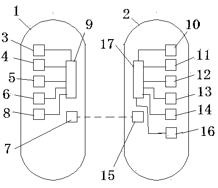
[0013] Such as figure 1 , figure 2 As shown, the present invention is realized in that the mother ship 1 equipped with some measuring equipment wirelessly connects the unmanned automatic surveying ship 2 equipped with some measuring equipment to form a double-vessel mode and simultaneously measure the geographical space of water areas, tidal flats and bank slopes. The measuring equipment of the mother ship 1 includes a three-dimensional laser scanner 3, an area array camera 4, a multi-beam echo sounder (1) 5, a single-beam echo sounder (1) 6, a radio station (1) 7, and a data storage device (1) 8 and the control circuit board (a) 9, the control circuit board (a) 9 is respectively connected to the rest of the above devices. The unmanned automatic survey ship 2 includes an unmanned ship automatic driving terminal 10, a navigator 11, an inertial navigation system 12, a multi-beam echo sounder (two) 13, a single-beam echo sounder (two) 14, a radio station (two) ) 15, data memor...
PUM
 Abstract
Description
Claims
Application Information