Vision-aided satellite navigation and positioning method, and positioning machine

A technology of satellite navigation and positioning method, applied in the field of navigation and positioning, can solve problems such as limited application, and achieve the effect of simplifying complexity, precise positioning, and improving positioning accuracy

Active Publication Date: 2014-09-10
ACAD OF OPTO ELECTRONICS CHINESE ACAD OF SCI
View PDF6 Cites 21 Cited by
  • Summary
  • Abstract
  • Description
  • Claims
  • Application Information

AI Technical Summary

Problems solved by technology

This method is relatively limited in actual use. On the one hand, it requires a large amount of information collection in advance. On the other hand, due to changes in the environment, the database needs to be continuously updated.

Method used


Image

  • Vision-aided satellite navigation and positioning method, and positioning machine
  • Vision-aided satellite navigation and positioning method, and positioning machine
  • Vision-aided satellite navigation and positioning method, and positioning machine

Examples


Embodiment Construction

[0042] The present invention will be described in detail below with reference to the accompanying drawings and examples.

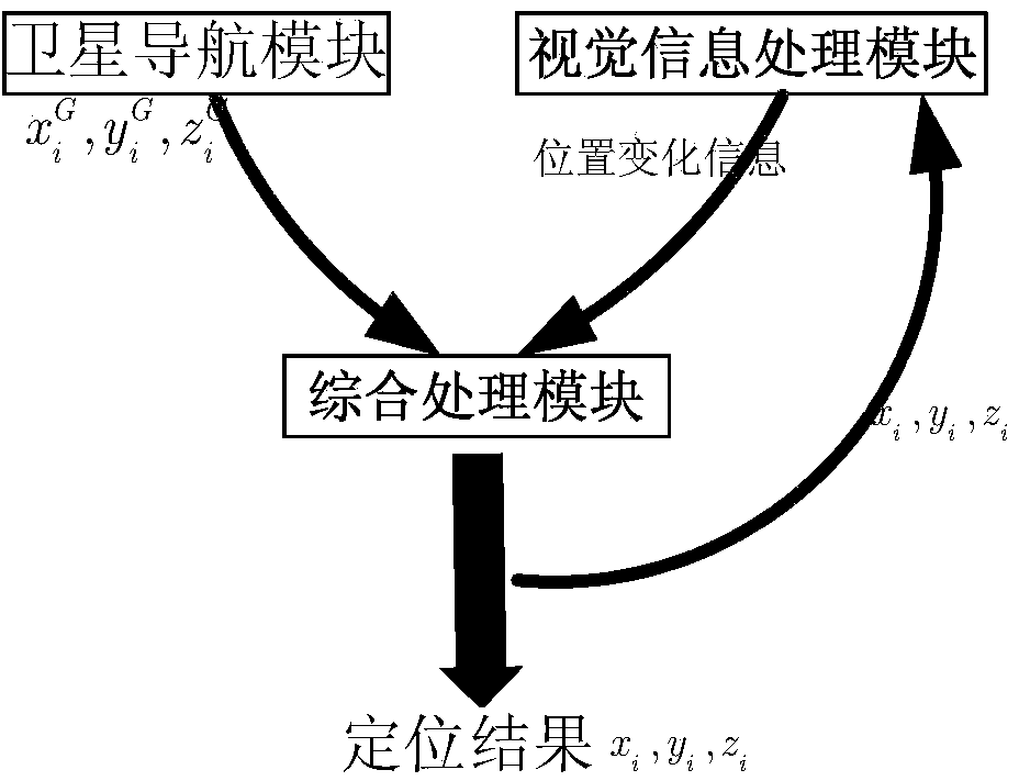
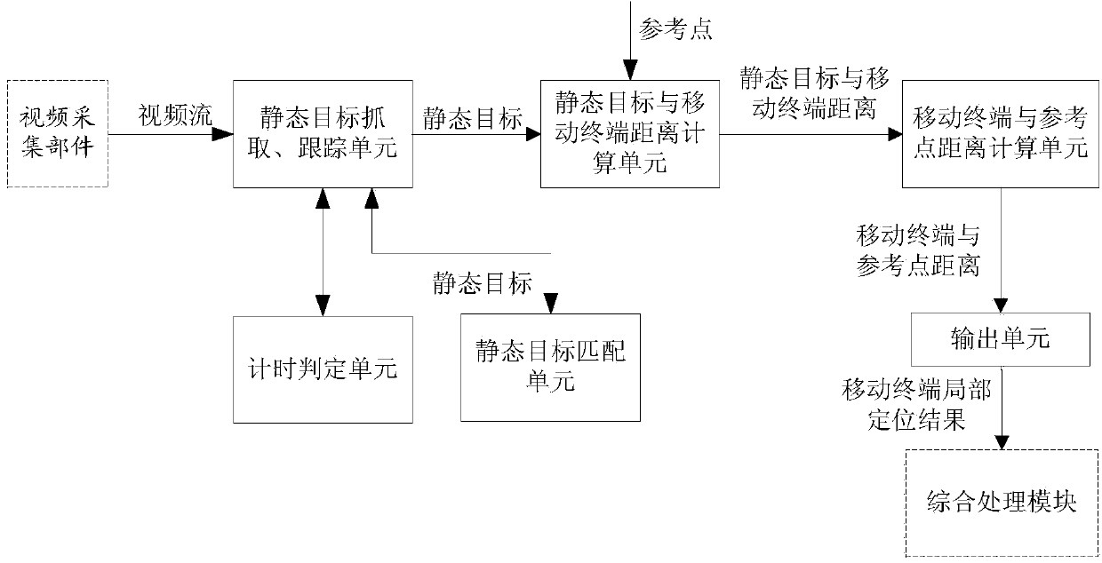
[0043] The present invention provides a visually assisted satellite navigation and positioning method, which uses video acquisition equipment to collect image information around the mobile terminal, analyzes and processes the video stream to extract the position change information of the mobile terminal relative to a reference point, and assists in correction The global positioning information measured by the satellite navigation receiver finally obtains high-precision positioning results.

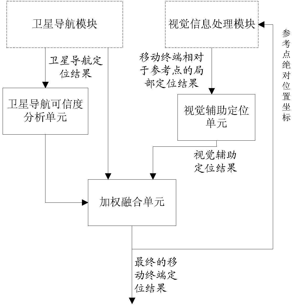
[0044] The positioning method of the present invention is based on a visually assisted satellite navigation positioning machine, and the positioning machine includes a satellite navigation module, a visual information processing module and a comprehensive processing module, such as figure 1 shown.

[0045] Among them, the satellite navigation module is a general-purpo...


PUM


Abstract

The invention discloses a vision-aided satellite navigation and positioning method. By using the vision-aided satellite navigation and positioning method disclosed by the invention, online positioning can be only depended without the need of carrying out data acquisition in advance, and a great effect is achieved on positioning under indoor, underground, dense-building environments and the like. According to the vision-aided satellite navigation and positioning method disclosed by the invention, image information around a mobile terminal is acquired by virtue of video acquisition terminal, analysis and processing are carried out on a video streaming to extract the position change information of the mobile terminal relative to a reference point, so as to auxiliarily correct the global positioning information measured by a satellite navigation receiver, and finally a high-accuracy positioning result is obtained; compared with the traditional mode, in-advance data acquisition is not needed, and only an online positioning process is needed, thus greatly simplifying the complexity of popularization; meanwhile, according to the vision-aided satellite navigation and positioning method disclosed by the invention, the positioning accuracy of satellite navigation and positioning is improved, and capable of achieving sub-meter scale; moreover, accurate positioning can be realized for cases with serious shielding or indoor conditions and the like.

Description

technical field [0001] The invention relates to the technical field of navigation and positioning, in particular to a vision-assisted satellite navigation and positioning method and a positioning machine. Background technique [0002] In recent years, location-based services (LBS, Location Based Services) are widely considered to be an important trend in the development of the information industry. System, GNSS), GNSS has the advantages of high positioning accuracy, 24-hour global availability, and not easily affected by weather and other factors, but the satellite navigation system itself has the inherent disadvantages of weak signal and easy to be blocked, which makes the application scenarios of GNSS greatly Restricted, for example, in areas such as urban streets and under viaducts, its positioning performance will be severely limited, and it will almost completely fail in indoor and underground areas. Therefore, the application of positioning methods based on cellular m...

Claims


Application Information

Patent Timeline
Patent Type & Authority Applications(China)
IPC IPC(8): G01S19/48
CPCG01S19/07G01S19/48
Inventor 魏东岩李祥红袁洪徐颖来奇峰公续平
Owner ACAD OF OPTO ELECTRONICS CHINESE ACAD OF SCI
Why Eureka
Try Eureka